Tag:highway=emergency_bay
 |
| Description |
|---|
| An area beside a highway where you can safely stop your car in case of breakdown or emergency. |
| Group: highways |
| Used on these elements |
| See also |
| Status: de facto |
| Tools for this tag |
The tag highway=emergency_bay is used for mapping an emergency bay - an area beside a highway (usually motorway or trunk road) where you can safely stop your car in case of breakdown or emergency. Emergency Bays are also known as Emergency Refuge Areas in the United Kingdom and as Accident Investigation Sites or Crash Investigation Sites in the United States.
It is usually sign posted with the following traffic signs:
-
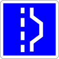
 German traffic sign 328
 -
 French traffic sign C8
 -
 Dutch traffic sign L14
 -
 Dutch traffic sign BB06
 -
 Belgian traffic sign F98
 -
 Belgian traffic sign IF2 (being phased out)
 -
 British traffic sign
 -
 Japanese traffic sign 116-6
 -
 Swedish traffic sign E27
 -
 South Korean traffic sign 427-4


.svg)


How to map
If there is no physical separation, add a ![]() node into a road way where the emergency bay is. Set
node into a road way where the emergency bay is. Set highway=emergency_bay on the node. For bidirectional roads, also set direction=forward or direction=backward to indicate which travel direction the emergency bay is for.
In case of physical separation between the emergency bay and the main road, draw the emergency bay as a short separate road segment ![]() way connected to the main road. Set the tag
way connected to the main road. Set the tag highway=emergency_bay on the new way representing the emergency bay.
See also
highway=passing_place- A passing place on a single track road.parking=layby- facility, often rural, alongside a major road where motorists can take a break en-route to their destinationhighway=rest_areafor rest areas that don't sell fuel. Also known as a 'turnout' (US).bus_bay=*- A bay outside the main carriageway for boarding/alighting.emergency=phone- emergency telephoneshoulder=*- shoulders, also known as breakdown lanes, often serves as an emergency stopping lanes