Tag:natural=strait
| Description |
|---|
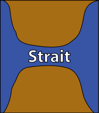
| A narrow area of water surrounded by land on two sides and by water on two other sides. |
| Rendering in OSM Carto |

|
| Group: natural |
| Used on these elements |
| Useful combination |
|
| Status: de facto |
| Tools for this tag |
|
A strait is a narrow area of water surrounded by land on two sides and by water on two other sides forming a connection between those bodies of water. Typical cases include passages between islands or connections of bays and gulfs to the open ocean. Straits are significant and often named features as either sea travel routes, for water exchange or as fish migration routes.
Straits exist in the ocean but also in larger lakes. They are not necessarily named strait, they are frequently also called channel, passage, sound or similar.
How to map
Straits can be mapped with either nodes, ways or as areas. Since the ends of a strait are often poorly defined like in case of a passage between two islands of convex shape it is often difficult to map them in a verifiable way as a way or an area.
- when mapping as a node this node should usually best be placed approximately in the middle between the coasts of the strait at the narrowest point - like formerly in case of the Drake Passage (which has meanwhile been changed to be represented with a non-verifiable polygon).
- when a strait is long, narrow and curved or has side channels or an otherwise complex and ambiguous coastline form it often makes sense to map it as a linear way. This should roughly follow the centerline of the water channel like in case of the Matochkin Strait.
- in cases where the ends of the strait are well defined you can also map the strait as a closed way or a multipolygon relation enclosing the area generally understood to constitute the strait. In this case the sides of the strait towards land should coincide with the coastline.
As of March 2018 there are about 760 straits mapped with nodes, 540 with linear ways and 290 with either multipolygons or closed ways. About 90 percent of the strait polygons are mapped in Scandinavia.
See also
- natural=bay + bay=fjord
- natural=peninsula
- natural=cape
- natural=isthmus
- seamark:type=sea_area + seamark:sea_area:category=narrows
External links
- Strait on Wikipedia
