Tag:seamark:light:1:category=upper
Jump to navigation
Jump to search
 |
| Description |
|---|
| Upper leading light. |
| Group: marine navigation |
| Used on these elements |
| Requires |
| Status: de facto |
| Tools for this tag |
|
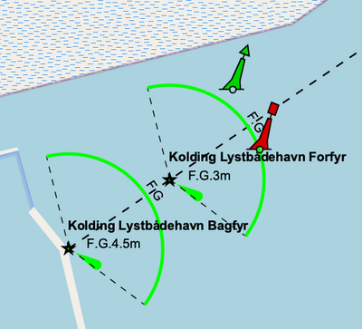
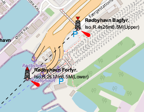
Leading lights are a pair of light beacons used in navigation to indicate a safe passage for vessels entering a shallow or dangerous channel. At night, the lights are a form of leading line that can be used for safe navigation. The beacons consist of two lights that are separated in distance and elevation, so that when they are aligned, with one above the other, they provide a bearing. Range lights are often illuminated day and night.
How to map
seamark:type=light_minorseamark:light:1:category=upperseamark:light:1:character=*seamark:light:1:colour=*seamark:light:1:sequence=*seamark:light:1:group=*seamark:light:1:range=*seamark:light:1:height=*seamark:light:1:sector_start=*seamark:light:1:sector_end=*seamark:light:1:orientation=*- direction in degreesseamark:name=*
Note that lights must bear a sector number (# = 1, 2, 3, ...) even if there is only one sector.
Tags to use in combination
seamark:type=beacon_special_purpose- cannot be used simultaneously withseamark:type=light_minorseamark:beacon_special_purpose:category=leadingseamark:beacon_special_purpose:colour=*seamark:beacon_special_purpose:shape=*seamark:beacon_special_purpose:height=*seamark:topmark:shape=*seamark:topmark:colour=*seamark:topmark:colour_pattern=*
Example in OpenSeaMap
Click to open the map
Click to open the map
See also
seamark:light:1:category=lower- It's the other light of the pair.seamark:light:1:category=rear- it is the same- Leading lights on Wikipedia