Tag:seamark:type=navigation_line
| Description |
|---|
| A straight line extending towards an area of navigational interest and generally generated by two navigational aids or one navigational aid and a bearing. |
| Group: marine navigation |
| Used on these elements |
| Status: de facto |
| Tools for this tag |
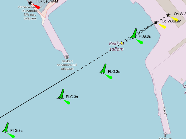
A navigation line is a straight line extending towards an area of navigational interest and generally generated by two navigational aids or one navigational aid and a bearing.
Navigation lines and recommended tracks are mapped as ways (usually just two nodes) laying along the path where the objects are to be displayed. The way should carry the tags for correct rendering. Nodes belonging to other objects, such as leading lights, may be used. The following illustration shows two navigation lines and two recommended tracks. The latter carry seamark:recommended_track:orientation=... tags in order for the bearing to be displayed. The values are decimal numbers, representing the bearing in degrees true.

Click to enlarge
How to map
Draw a way ![]() at the navigation line and add
at the navigation line and add
seamark:type=navigation_lineseamark:navigation_line:category=*seamark:navigation_line:category=clearing- A straight line that marks the boundary between a safe and a dangerous area or that passes clear of a navigational danger.seamark:navigation_line:category=transit- A line passing through one or more fixed marks.seamark:navigation_line:category=leading- A line passing through one or more clearly defined objects, along the path of which a vessel can approach safely up to a certain distance off.
Example in OpenSeaMap
Click to open the map
See also
seamark:type=recommended_track- the solid line in the diagram aboveseamark:type=fairway- A navigable area in a lake or sea, often marked by buoys or beacons.- Seamarks/Leading_Lines