Tag:seamark:type=recommended_track
Jump to navigation
Jump to search
| Description |
|---|
| That portion of a 'navigation line' that a ship should use for navigation. |
| Group: marine navigation |
| Used on these elements |
| Status: de facto |
| Tools for this tag |
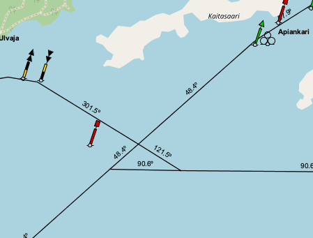
Navigation lines and recommended tracks are mapped as ways (usually just two nodes) laying along the path where the objects are to be displayed. The way should carry the tags for correct rendering. Nodes belonging to other objects, such as leading lights, may be used. The following illustration shows two navigation lines and two recommended tracks. The latter carry seamark:recommended_track:orientation=... tags in order for the bearing to be displayed. The values are decimal numbers, representing the bearing in degrees true.

Click to enlarge
How to map
Draw a way ![]() at the navigation line and add
at the navigation line and add
seamark:type=recommended_trackseamark:recommended_track:category=*seamark:recommended_track:category=fixed_marksseamark:recommended_track:category=no_fixed_marks
seamark:recommended_track:minimum_depth=*- minimum depth in meterseamark:recommended_track:orientation=*- bearing in degrees true
Example in OpenSeaMap
Click to open the map
See also
seamark:type=navigation_line- the dashed line in the diagram aboveseamark:type=fairway- A navigable area in a lake or sea, often marked by buoys or beacons.- Seamarks/Leading_Lines