Tag:sport=tetherball

From OpenStreetMap Wiki
Jump to navigation Jump to search
Public-images-osm logo.svg sport = tetherball
Tetherball flickr.jpg
Description
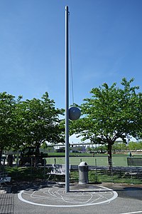
Tetherball is a game where two players use their hands to strike a volleyball which is suspended from stationary metal pole by a rope or tether. Show/edit corresponding data item.
Group: sports
Used on these elements
may be used on nodesshould not be used on waysmay be used on areas (and multipolygon relations)should not be used on relations (except multipolygon relations)
Useful combination
Status: in use

How to map

Add this tag to any place where there is a tetherball court.

The tag sport=tetherball (all lowercase) should be combined with a physical tag:

Additional tags

Example images

Hunters Point South Pk td (2019-05-11) 012 - Tetherball Monument.jpg

Smoker Family Park (2).jpg

Alternative tagging

As of January 2022, a significant number of tetherball poles mapped as a node are tagged as playground=tetherball

Possible tagging errors

If you know places with this tag, verify if it could be tagged with another tag.
Automated edits are strongly discouraged unless you really know what you are doing!
If you know places with this tag, verify if it could be tagged with another tag.
Automated edits are strongly discouraged unless you really know what you are doing!
If you know places with this tag, verify if it could be tagged with another tag.
Automated edits are strongly discouraged unless you really know what you are doing!

External links

https://en.wikipedia.org/wiki/Tetherball