Talk:Key:winter road
Why should this be limited to "northern regions"?
The definition currently reads: "Seasonal roads in northern regions that are functioning during winter, usually impassable in summer.". I don't see any reason to not use this in the South as well. If nobody objects I will remove the "northern regions" part. --Dieterdreist (talk) 11:18, 17 February 2016 (UTC)
- Because only in the northern hemisphere we got large territories that are frozen in winter and not frozen in summer, and have population. In the southern hemisphere we have mostly ocean at the corresponding latitudes, further to the south is Antarctic, which doesn't have roads and population. To my knowledge, winter roads exist only in Russia, Canada and probably Alaska. If you know about any winter roads in Antarctic, you are welcome to remove "northern" Glebius (talk) 18:00, 17 February 2016 (UTC)
Highway tag should be present
I don't agree with the recent changes to Key:winter_road, which changed "The highway=* should also be present" to "may".
The highway tag SHOULD be present, as long as the road isn't historical. Indeed it may be missing on segments that weren't used in last years, but your change doesn't explain that. There is enough explanation in "Mapping sections that differ from year to year". With initial mapping the highway tag must be present, it can be removed later in favor of a newer segment. But drawing a new winter road without putting the tag doesn't make any sense for the map. -- Glebius, 27 December 2019
- I generally try to avoid the word "should" in Tag and Key description pages, since it sounds like a command rather than a description. In this case it's not clear if
highway=*is required, because later it is mentioned that this tag can be used for old routes of winter roads which are no longer used. But can see how the new phrasing is less clear. How about we change it to "highway= is also used... with a value that reflects..."? --Jeisenbe (talk) 05:22, 28 December 2019 (UTC)
- I strongly believe that description of tags/keys in the database is a protocol, thus description must be precise and do not allow misinterpretations. When using word "should" I follow the RFC principles on how a protocol is defined. See https://tools.ietf.org/html/rfc2119. Check out definition of SHOULD there. IMHO, it perfectly matches how highway= should be applied to winter roads. Glebius (talk) 31 December 2019
Official status of winter roads
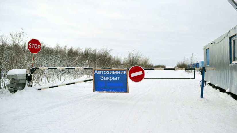
Second, dropping note about official status is also unnecessary. It is a very good clue for those who aren't familiar with arctic. In most cases if local authorities declare road a winter road, then it should be mapped so, otherwise not. -- Glebius, 27 December 2019
- We can add that back, but how should mappers determine if a winter road has official status? Are there road signs? Why shouldn't we map winter roads which do not have official status? --Jeisenbe (talk) 06:24, 28 December 2019 (UTC)
- Yes, official winter roads always have signs and information boards on entrance, telling either it is now officially opened or officially closed. Here is example from Internet: https://newdaynews.ru/pict/arts1/67/89/678968_b.png.jpg Mappers who map winter roads are expected to know what they are doing :) It is impossible to map a winter road via satellite imagery. It is possible only to use a GPS trace. However, blindly tracing a GPS trace of unknown origin in the arctic is a mistake. This could be a trace of a snowmobile. So, a mapper should be aware of what exactly he is drawing right now. Glebius (talk) 31 December 2019
Non winter roads?
In Switzerland we have mountain roads which are closed during winter. Some infrastructure gets removed by the government during that time. Additionally, a barrier is added. So it's basically the inverse of a winter road.
Example website that contains most Swiss ones https://www.alpen-paesse.ch/de/