Talk:Relief maps
Discuss Relief maps page here:
Transparent overlay mashup - where?
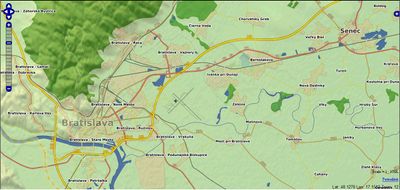
I thought I saw a mashup, maybe one of User:Ojw's, with OSM map tiles looking semitransparent overlaid on shaded relief maps.
And how was this image created? Looks like a screenshot of that mashup, but where it is running? :
-- Harry Wood 16:43, 26 October 2007 (BST)
- Most likely http://freemap.sk: http://www.freemap.sk/?zoom=11&lat=48.07168937154909&lon=17.231355744529836&layers=BTTTTT --Colin Marquardt 17:51, 26 October 2007 (BST)
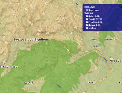
- now we have also topo (contour lines) layer; gyus at http://www.gps-maps.info has done conversion from SRTM and other DEM souces to vectorized contour lines in polish format compiled to IMG suiatable for garmin devices. TOPO20SK was converted from polish format to osm, then splitted into tiles z12-sized tiles and rendered individualy tile-by-tile az zoom level 12 using sligthly modified t@h in xy mode (http://www.freemap.sk/?lon=17.55368829135909&lat=48.64778730813385&zoom=12&layers=BTTTTF) --Dido 14:46, 27 October 2007 (BST)
Discussion about relief colour scale
(moved from article) Gravitystorm 17:29, 8 December 2008 (UTC)
a proposal
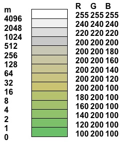
Altitude-coded colour bands are more useful than shading or contours, giving information about (approximate) absolute elevation (which colour) and, more importantly, steepness of terrain (rate that colours change). A possible approach would be to colour bands at increasing (geometric as oppose to arithmetic) heights above sea level with the band width doubling for each band. This shows small but significant terrain changes at lower altitudes without the need for large numbers of bands in mountainous areas. The colour scheme here (easily implemented as an algorithm) uses greens for low altitudes shading through tan colours for hilly areas to greys for mountains, with all very high mountain areas in the >4095m shown white. (This should be discussed. Djam 10:53, 20 July 2008 (UTC))
Rather creating shape files for contours or bands, they could be processed as bitmap relief image tiles used as backgrounds to transparent tiles showing roads and other features. The elevations could be taken from the 3-arc-second SRTM data set and the relief tiles would only need to be produced once as (barring volcanoes and earthquakes) the terrain does not change rapidly. --Elvinibbotson 09:22, 20 March 2008 (UTC)
Hello !
I am really amazed by the work done by many people to improve the map, for example taking altitude into account. That's great. Altitude-coded colour bands are a good solution for the description of very large maps. However, I'm in trouble with the scale that has been chosen : If I understand it well, there are as many colours to describe altitudes between 0 and 64 m high as from 64 m (not so high to my mind) up to the Everest Mount ? This sounds crazy !
In many countries, 4096 m is considered as a very high altitude, but that is not the case everywhere : the mean altitude of Tibet is higher than 4000 m, and it's capital, Lhasa is about 3650 m high. I would be pained if the only altitude distinction there was a line showing if places are below or higher than 4096 meter. It is the same in South America, for example in Bolivia's capital, La Paz, where the Airport and a large part of the city is above 4000 m.
That was concerning the scale. Concerning the altitude-coded colour bands, these are not kind to use anymore at high zoom level, for detailed study of a place, or when you are climbing into the mountains for example, so that is good if contours are available at high zoom levels.
Djam 10:47, 20 July 2008 (UTC)
P.S: As it is hard to explain things in a foreign language, please be sure I only try to be positive, and that I have great consideration to the work that has been done.
maps-for-free and cleanup
The above named website has an incompatible license with osm (GNU FDL), and we've got plenty of non-encumbered examples nowadays. Also, I reckon this page is better if generalised to discussions of relief maps in an OSM context, rather than discussing outdated plans that didn't make it off the drawing board. Gravitystorm 17:04, 8 December 2008 (UTC)


