Talk:Tag:barrier=entrance
Jump to navigation
Jump to search
We need this kind of barrier defined --http://chris-researchblog.blogspot.com/ 09:41, 2 February 2010 (UTC)
Implies?
What does "access=yes is understood" mean? Is access=yes implied like in the german version of the page?
- yes, from my understanding it is implied by default but as always might be overruled by explicit access tags. —Dieterdreist (talk) 20:47, 1 September 2018 (UTC)
- Not at all! Imagine a residential property, there is a garden that starts next to the house and continues on the back. There is a barrier at the front with a gap as a passage. Certainly this passage does not implicitly suggest that the access is authorized, it is obvious that it is a private propriety by its residential nature. Remember that access is primarily a legal description even though some specific values like access=no have a physical interpretation as well, suggesting that it is physically impossible to use (example: collapsed passage of a high and wide wall).
- This is an occasion to add that we should avoid features with definitions that go too much against the general consensus, even though i guess some situations can be specific by law depending of the feature but these are usually expressed on the tag with a specific value or prefix/suffix country code either on the key or value. OSM is an international project meant for everyone to use, therefore to understand. It would be illogical to have a Map legend for each country. --SHARCRASH (talk) 12:02, 16 October 2023 (UTC)
Do we really need this?
I know there is a fair amount of use of this tag and it has been used since 2009, but is it really necessary to have this tag?
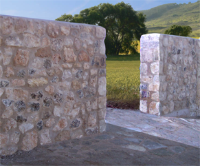
Using the example wiki image:

Instead of making a single way representing the wall and a barrier=entrance at the intersection of the street:

Why not simply represent the object as it really is without using a continuous wall/barrier/way?

--naoliv (talk) 17:43, 31 July 2019 (UTC)
- In situations like this I would also map the gap in geometry, but there is also the situation of a hole inside a fence or wall.—Dieterdreist (talk) 20:56, 31 July 2019 (UTC)
- While there's something to be said for the simplicity of just leaving a gap in the linear barrier, one benefit of using a barrier=entrance node is the ability to add tags like access or maxwidth to it. --Tordanik 15:52, 1 August 2019 (UTC)
- I agree with your logic... but, as others have suggested, this feature does have other uses: keep in mind that some editors like iD, meant primarily for beginners, are really tedious for elaborated plotting. When a contributor plotted a big area which has a barrier of a single type around the complete perimeter, it would just need to add the according tag "barrier=*" to the area already plotted. If a highway passes that area, therefore crosses the barrier, there is no need to replot it separately. Just intersect the highway with the area/barrier and add the barrier=entrance on the intersection.--SHARCRASH (talk) 11:35, 16 October 2023 (UTC)