Talk:Tag:landuse=farmyard
Classifying Types of Farm
* Subsequently resolved - see below. *
'Morning, fellow mappers...
I am currently passing some spare time filling in a largely blank area of the map in my home vicinity and am going for maximum detail. There are a lot of farms in the area - a lot. In tracing the farmyards I've been minded that it might be useful to hold in the database information on the type of farm. To which end I've been adding the experimental tag "farmyard:type=" to the farmyard polygons, having not found anything similar or suitable already listed in OSM Wiki.
Values used so far are:-
dairy - for farms engaged primarily in milk production
livestock - for farms engaged primarily in animal husbandry for meat/breeding
mixed - for farms engaged in a mixture of animal husbandry and the growing of crops
arable - for farms engaged primarily in the growing of crops
poultry - for farms engaged primarily in the rearing of chickens/turkeys
These seem to be the principal classifications for farms, in the UK at least. There may be others globally but I can't think of them at this time ("subsistence" for remote, undeveloped regions perhaps?). There could also be scope for expansion into tags indicating the breed of the herd or whether the nature of arable farming is primarily cereals or vegetables, fruit, etc I would imagine.
There doesn't seem much scope for this to affect rendering, unless a consensus is arrived at that rendering by classification is desirable (common base colour with different coloured hatching for each classification, perhaps?). However, it does occur that a more useful use would be to tag the entire holding - i.e. the farmyard and all fields owned or leased by that farm. Whether this would best be by an enclosing polygon or by a relation I'm not sure. It would also require the mapper to know which land parcels belong to or are used by a given farm. In this instance perhaps "farm:type=" would be a better tag?
Which puts me in mind to think that "farm:type=" might be better than "farmyard:type=" even when applied solely to the farmyard polygon.
Whilst I may now be a reasonably dab hand at editing the map I'm new to editing OSM Wiki and so have not added anything to the main page for this tag. Also, I've no idea how one goes about generating an "official" tag or key that would render on the map or who indeed is even in charge of configuring the rendering for openstreetmap.org! At the moment I'm merely seeking the views of more seasoned Wiki-ers as to viability, utility, etc.
--John Grubb (talk) 07:06, 11 September 2018 (UTC)
- Hi there. I like your idea. Although, there is already a crop type classification for farmland, I don't think there is one for farmyard types. Id like to see one for chickens. As there are a bunch of chicken coup areas where I live and it would be cool to separate them from plain farmyards. I think it is best to go with farmyard:type and not farm:type. As both amenity=farm and landuse=farm are currently in the "possible tagging mistakes" section. As far as how to get the tags widely accepted. There seems to be two ways at this point, 1. Use the tag a lot until more people use it. Then once it gets widely it accepted it will be considered "in use" and can be added to the main farmyard page. 2. Write a proposal for it and hope you get enough votes. Out of those options, one seems to be the easiest. Although it takes more time for wider adoption. You can also combine them to. Use the key for a couple of years and then write the proposal after it gets refined enough. A lot of it has to do with testing. There's a lot of keys laying around in the key junkyard that were road tested, still have some uses, but never went beyond that stage. That doesn't mean they aren't good tags or not worth using though. It really depends. Park:type is a good example. There's a lot of uses of it, it never got voted on or anything, but it just doesn't fit right for some reason and although it is being used it will never be "mainstream" or rendered on the main map. That doesn't mean other maps might not use it though. A lot of things are to different by culture to tie down. Farmyard might be one. You should still use it if you feel like though. It also might be worth doing research on tag info for similar tags, junk ones, or one offs that can be integrated into it. Its a good way to brain storm things. As far as rendering goes on the main map goes, it wont be for a long time and after you go through the other steps for it to happen. Although rendering or not shouldn't factor into how or what you map. Otherwise, your mapping for the render. This overall a database of geographical information. The map is just a way to show that off, but its not the main purpose of OpenStreetMap. --Adamant1 (talk) 22:06, 12 September 2018 (UTC)
- Oh yeah, btw I was just looking at other keys and noticed some other sub-types like shop=clothes is just clothes=* so I looked it up for farmyard and there is 785 instances of farmyard=* on Taginfo, which covers all the types you have mentioned and more. So creating your own farmyard:type is pretty pointless since its essentially already being done and used a lot. If I were you, I would research its origins, uses, etc more. Then go with that and add it to the landuse=farmyard main page. Instead of creating an off branching key unnecessarily. I might actually do it myself eventually if I have the time. --Adamant1 (talk) 22:23, 12 September 2018 (UTC)
- Oh yeah, btw I was just looking at other keys and noticed some other sub-types like shop=clothes is just clothes=* so I looked it up for farmyard and there is 785 instances of farmyard=* on Taginfo, which covers all the types you have mentioned and more. So creating your own farmyard:type is pretty pointless since its essentially already being done and used a lot. If I were you, I would research its origins, uses, etc more. Then go with that and add it to the landuse=farmyard main page. Instead of creating an off branching key unnecessarily. I might actually do it myself eventually if I have the time. --Adamant1 (talk) 22:23, 12 September 2018 (UTC)
- Another good spot! Link for others' reference: https://taginfo.openstreetmap.org/keys/farmyard#values. I can see farmyard=livery being quite useful in my neck of the woods, too - there's gazillions of commercial and private stables around here. Farmyard=* it is, then. Job's a good'un. --John Grubb (talk) 15:38, 15 September 2018 (UTC)
- Another good spot! Link for others' reference: https://taginfo.openstreetmap.org/keys/farmyard#values. I can see farmyard=livery being quite useful in my neck of the woods, too - there's gazillions of commercial and private stables around here. Farmyard=* it is, then. Job's a good'un. --John Grubb (talk) 15:38, 15 September 2018 (UTC)
- Good spot! I have amended my original text as I completely forgot about poultry farms - two of which I have already tagged in the area I am currently detail-mapping. I think that there might be scope for a tag to cover "hobby" farms, too. For example, there is a small holding in my area of which the present owners have used to develop a "glamping" business but whom also rear "odd" species such as alpacas, not for market but almost as pets. They also run a small flock of sheep and have a sty, the organically-reared lamb and pork products so yielded being sold to their glampers through their farm shop. Clearly this farm is not really a farm in the commercial sense but is still a farm in terms of landuse and stewardship. Perhaps faryard:type=hobby or farmyard:type=small_holding to classify those sort of farms??
- Good spot! I have amended my original text as I completely forgot about poultry farms - two of which I have already tagged in the area I am currently detail-mapping. I think that there might be scope for a tag to cover "hobby" farms, too. For example, there is a small holding in my area of which the present owners have used to develop a "glamping" business but whom also rear "odd" species such as alpacas, not for market but almost as pets. They also run a small flock of sheep and have a sty, the organically-reared lamb and pork products so yielded being sold to their glampers through their farm shop. Clearly this farm is not really a farm in the commercial sense but is still a farm in terms of landuse and stewardship. Perhaps faryard:type=hobby or farmyard:type=small_holding to classify those sort of farms??
I'm way off creating a proposal, least of all because I've no idea how to go about it. I'd like more views from other experienced Wiki'ers first, though. With this tag I'm aiming more at adding information to the database than having pretty colours appear on the map one day so that I can feel smug and go, "I did that!" :)
--John Grubb (talk) 07:41, 13 September 2018 (UTC)
- I think your tagging what the farm produces? In which case the tag
produce=*already covers it? Warin61 (talk) 00:17, 6 December 2021 (UTC)
landuse=farmland section
I happen to notice that the part in the landuse=farmland section where it says farmland is for "Wide open space for grazing animals" was added before the creation of the landuse=meadow tag. It would be good if that part was removed so there isn't any confusion as to the usage of landuse=farmland as exclusively for crop tillage. It's pretty clear on the landuse=farmland page that places for animal grazing should be tagged as landuse=meadow. This page should reflect it. The pictures on both pages should be modified to be clearer about it also. --Adamant1 (talk) 08:25, 16 May 2019 (UTC)
- How does this work with mixed farms where arable and grazing fields are rotated to avoid soil damage and allow natural fertilising from cattle faeces? A lot of farms in my area are mixed and, for example, a given field will be used for wheat in one year, rapeseed the next, left fallow and cut for hay in the third and then grazed in the fourth with the farms beef herd or sheep. https://en.wikipedia.org/wiki/Crop_rotation I struggle to keep on top of all the housing development around here let alone have time to monitor a considerable square mileage of farmland to see which field is being used for what purpose from year to the next to keep the map current!! --John Grubb (talk) 19:10, 5 June 2019 (UTC)
- added before the creation of the landuse=meadow . I don't think that's the whole story because
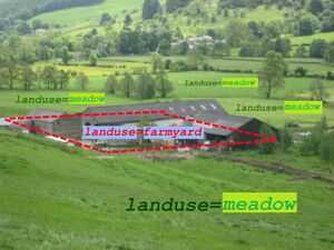
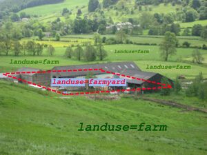
landuse=farmwas used similarly to, and then superceded bylanduse=farmland. It wasn't always written very clearly, but I think I liked the idea of having a highly generic tag which can apply to any kind of farm field (cattle grazing or arable). Handy for mappers who don't know (e.g. can't tell from aerial imagery) as well as for the case John is describing, where the landuse fluctuates. I thinklanduse=farmlandis still good for that. But I suppose it was always the idea that mappers would use a more specific landuse tag if they could/wanted. - So the picture currently is modified to show landuse=meadow instead of landuse=farmland now (and before that it used to show landuse=farm)


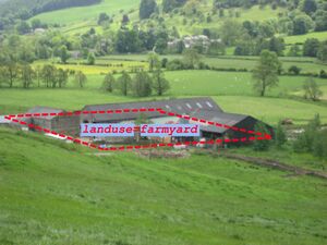
Now, I've uploaded this image with stays out of that discussion by just showing landuse=farmyard...
- ...which I had in mind to swap in on this page. But maybe that would miss the point that I was originally trying to explain here. The point is farmyard is just for the area with the farm buildings, and beyond that ... other tags ... for the fields.
- -- Harry Wood (talk) 01:30, 20 December 2021 (UTC)
- added before the creation of the landuse=meadow . I don't think that's the whole story because
- So I'm now going to swap the image on this page to File:Landuse=farmyard and landuse=meadow.jpg from the current File:Landuse=farmland.jpg. These images are currently showing the same thing, so this is no change at all...
- The interesting (debatable?) change took place here File:Landuse=farmland.jpg#filehistory by User:GoodClover June 2021 to begin showing landuse=meadow tag in the image. Done without discussion at the time, but there is this: File talk:Landuse=farmland.jpg.
- -- Harry Wood (talk) 15:49, 22 March 2022 (UTC)
agro industry
How do we tag agroindustry and could that be claryfied here? E.g. sugar production facility within large sugar cane fields or large poultry farmes in my view are landuse=industrial !?
- Large animal husbandry areas are sometimes tagged as
landuse=farmyardinstead, for example poultry farms used to produce eggs. If there is an industrial factory or works where farm products are processed, such as a dairy, sugar processing factory, or food canning plant, or a large are of warehouses, these can indeed be mapped withlanduse=industrial. Also seeman_made=worksfor industrial factories (works). --Jeisenbe (talk) 21:46, 6 July 2020 (UTC)
Residential area?
Usually part of the farm is given over to residential use - where the house/home/ranch house/homestead is located. Sometimes these areas incorporate other residential features such as decorative garden, swimming pool, tennis court etc.These areas would be best mapped as landuse=residential rather than landuse=farmland. Warin61 (talk) 00:22, 6 December 2021 (UTC)
Clarification
There seems to be a loss of way in parts here. Gentle reminder that this is the discussion for the Wiki page for the tag landuse=farmYARD and not the page for landuse=farmLAND. They are two distinct things, one being the centralised precinct of farmhouse, barns, tractor sheds, animal sheds, etc. and the other being open fields. --John Grubb (talk) 00:58, 6 December 2021 (UTC)