UK 24 hour mapathons
About
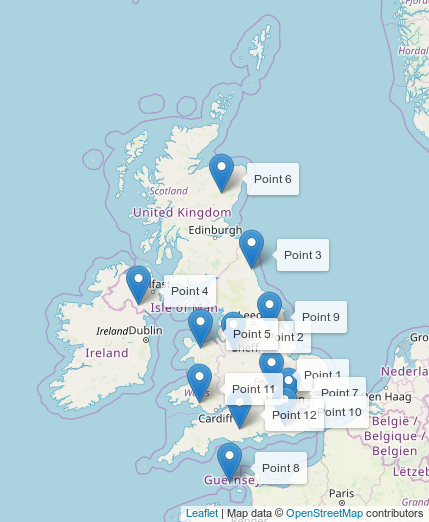
Inspired by Tshedy's April 2019 24-hour mapathon, we have created our own list of regions for the UK OpenStreetMap community. We've picked one area per month and the day is selected randomly to give as many people a chance to get involved as possible. Instead of one mapper working for 24 hours we welcome everyone to help map the specified region at time that suites them within the 24hour window.
Regions are picked to be very roughly equal in population, and include the Isle of Man and the Channel Islands alongside the UK. All are welcome - from absolute beginners to experienced mappers. There is no need to live near the region but if you are contributing from afar, please see A Note of Warning below.
Guidance
New to OpenStreetMap?
Welcome to the worlds most collaborative map! We're building a map of things that matter to people like me and you. No big organisation controlling what you see on the map, no preference to advertisers and no fees.
To get started head to openstreetmap.org and click Edit. If you don't already have an account please register. Once done you can start editing using the iD in-browser editor. There is a built in walkthrough to teach you the basics. Once complete you can start contributing to the mapathon - perhaps start with something simple like adding building outlines.
What to map
You are free to map what you like. Short of ideas? Look at the Wiki pages of previous 24hr mapathons to see what's been done in the past. If a wiki page doesn't exist yet, create it and put a link in the table above. If it does exist, edit it to include your name and show interest or add bits/info that you think could be helpful.
A Note of Warning
OpenStreetMap is at its best when local people help map their local areas. It easy to go out and look at something in person before adding it to the map. Our mapathons might not be close enough for you to visit in person. On the plus side this encourages us to map away from our normal places, helping to fill gaps where their might not be local mappers and allowing us to see how other places are mapped (to review consistency). On the down side it increases risk of getting something wrong as we're reliant on aerial imagery, street imagery and other open data without being able to check in person. As a rule of thumb, if in doubt about something add an OSM Note instead of editing.
The mapathon list
Locations and times of our 24 hour mapathons:
| Date | Region |
| Wed, 12 Jun 2019 | Milton Keynes South (Wiki page)(map) |
| Tue, 09 Jul 2019 | Crewe and Nantwich (Wiki page)(map) |
| Sun, 11 Aug 2019 | Wansbeck: Ashington, Bedlington, Newbiggin-by-the-sea (Wiki page)(map) |
| Fri, 13 Sep 2019 | Newry and Armagh (map) |
| Wed, 09 Oct 2019 | Aberconwy (boundary map) |
| Tue, 12 Nov 2019 | West Aberdeenshire and Kincardine (boundary map) |
| Fri, 13 Dec 2019 | West Ham, London (boundary map) |
| Thu, 09 Jan 2020 | Bailiwick of Guernsey (map) |
| Mon, 10 Feb 2020 | Brigg and Goole (boundary map) |
| Sat, 14 Mar 2020 | Mid Sussex (boundary map) |
| Thu, 09 Apr 2020 | Swansea East (boundary map) |
| Mon, 11 May 2020 | North Dorset (boundary map) |
This gives a good geographic split of regions:
