User:BubbleGuppies
To-Do Projects
1. Cleanup marker tags
- change ref:US:hmdb to ref:hmdb
- change heritage:website to memorial:website
Helpful How-To's
- Relations in JOSM
- Pedestrian areas area:highway=footway or area:highway=steps
Pedestrian Tags
Crossing with flashing light (not at streetlight)
button_operated=yes
crossing:island=no
crossing:markings=zebra/zebra:skewed/etc.
crossing:signals=no **Note this is not a vehicle stoplight
crossing=marked
flashing_lights=button
footway=crossing
highway=footway
surface=asphalt
crossing lanes with signals and stripes
https://wiki.openstreetmap.org/wiki/Tag:footway%3Dcrossing
highway=footway
footway=crossing
crossing=marked/unmarked
button_operated=no/yes
traffic_signals:sound=yes/no
crossing:island=no/yes
crossing:markings=zebra/zebra:skewed/etc.
crossing:signals=no/yes
pedestrian access aisle in parking lot
highway=footway
footway=access_aisle
wheelchair=yes
access_aisle=disabled
crossing without paint but different surface
crossing:markings=surface
surface=paving_stones
My Common Tags
artwork
artist:wikidata=Q5311822
artist:wikipedia=en:Dudley C. Carter
artist_name=Dudley Carter
artwork_type=sculpture
material=red cedar
name=Seagull On A Post
start_date=1960
tourism=artwork
wikimedia_commons=File:Seagull On A Post, by Dudley Carter.jpg
Swimming Pools with concrete pad
Tag the entire relation (i.e. inner and outer)
bicycle=no
foot=designated
highway=pedestrian
horse=no
lit=no
motor_vehicle=no
surface=concrete
type=multipolygon
Then you can tag the inner (pool)
access=private
leisure=swimming_pool
lit=no
location=outdoor
sport=swimming
swimming_pool=inground
Fire Stations
Example
addr:city=Denton
addr:housenumber=2230
addr:postcode=76207
addr:state=TX
addr:street=West Windsor Drive
building=fire_station (for the actual building)
amenity=fire_station (for the grounds)
contact:facebook=https://www.facebook.com/dentonfire
contact:instagram=https://www.instagram.com/dentonfiredepartment/
contact:phone=+1-940-349-8105
contact:twitter=https://twitter.com/dentonfiredept
contact:website=https://www.cityofdenton.com/en-us/government/departments/denton-fire-rescue
description=STATION 5 HOUSES\n- Quint 5\n- Medic 5\n- Brush 5\n- Hazmat 5
fire_station=generic
fire_station:team=professional
wikidata=110360677
name=Station #5
note=Fire Station #5 is dedicated to Chief Jack Gentry for his many years of service with Denton.
operator=City of Denton
operator:type=public
operator:wikidata=Q128306
operator:wikipedia=en:Denton, Texas
start_date=1990
ref=5
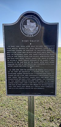
Texas Historical Markers
- name=Fort Travis
- historic=memorial
- memorial=plaque
- material=aluminium
- support=pole
- operator=Texas Historical Commission
- operator:wikidata=Q2397965
- thc:designation= Historical Marker/ Recorded Texas Historic Landmark
- thc:inscription=
- ref:US-TX:thc=7452
- ref:hmdb=83304
- ref:nrhp=
- memorial:website=https://www.hmdb.org/m.asp?m=83304
- website=https://atlas.thc.state.tx.us/Details/5167007452
- wikimedia_commons=File:Texas historical marker for fort Travis.jpg
- start_date=1993
- flickr=https://www.flickr.com/photos/23718360@N06/54060347231/in/pool-texashistoricalmarkers/
- subject:wikipedia=https://ceb.wikipedia.org/wiki/Fort_Travis_Seashore_Park
- subject:wikidata=Q49490784
Poop Bags
amenity=vending_machine
vending=excrement_bags
fee=no
bin=*
operator=City of Denton
operator:wikidata=Q128306
State Parks
- https://en.wikipedia.org/wiki/List_of_Texas_state_parks
- United States/Public lands#State Public Lands
Possible tags, still in progress
name=
alt_name = <maybe a shorter name than the official one>
operator = Texas Parks and Wildlife Department
operator:wikidata =
ownership = state
boundary=protected_area (required with protection_title)
protection_title = State Park
protect_class = 2 (is this park unique or all state parks?)
wikidata =
wikipedia =
gnis:state_id
gnis:county_id
gnis:feature_id
gnis:created
ele
fee
phone = [[1]]
start_date = <check out wiki page>
website = https://tpwd.texas.gov/state-parks/xxxxxx
boundary = protected_area (is this park unique?)
camping = yes/no
area:size
City Parks
Example
addr:city=Denton
addr:housenumber=1001
addr:postcode=76205
addr:state=TX
addr:street=Parvin Street
camping=no
contact:email=parksnrec@cityofdenton.com
contact:phone=+1-940-349-7275
contact:website=https://www.cityofdenton.com/en-us/all-departments/quality-of-life/parks-recreation-(1)/nature-initiatives/parks-and-playgrounds/denia-playground-and-pavilion
description=23-acre, community park, sports complex, and recreation center located at 1001 Parvin St.\n\nTrail (0.63 miles, concrete)\n\nAmenities include:\nPavilion; capacity 36 people\n1,090 square feet\nSix picnic tables (not movable)\nGrill available\nPlaygrounds\nBasketba
drinking_water=yes
fee=no
gnis:county_id=121
gnis:created=02/11/2004
gnis:feature_id=2028491
gnis:feature_type=park
gnis:reviewed=yes
gnis:state_id=48
image=https://commons.wikimedia.org/wiki/File:DeniaParkDentonTexas.jpg
leisure=park
name=Denia Park
notes=Land was gifted by historical Denton figure Newton Rayzor, per https://dentoncountyhistoryandculture.wordpress.com/2019/11/15/whos-who-in-denton-county-newton-rayzor/
opening_hours=Mo-Su 06:00-22:00
operator=City of Denton
picnic_table=yes
wikidata=Q107643777
operator:type=public
operator:wikidata=Q128306
operator:wikipedia=en:Denton, Texas
Schools
Example
addr:city=Denton
addr:housenumber=1212
addr:postcode=76210
addr:state=TX
addr:street=Hickory Creek Road
amenity=school
contact:facebook=https://www.facebook.com/McNairElementarySchool
contact:phone=+1-940-369-3600
contact:twitter=https://twitter.com/McNair_DISD
grades=K-5
kindergarten=yes
mascot=Commanders
name=McNair Elementary School
operator=Denton ISD
operator:type=public
operator:wikidata=Q5259616
operator:wikipedia=https://en.wikipedia.org/wiki/Denton_Independent_School_District
religion=none
school=elementary
start_date=1987
website=http://www.dentonisd.org/mcnaires
Street Cred
- My Mapillary Profile - Ugh! So much drama here that I'm taking a break from mapillary.
- How Did I Contribute to OSM?
- My OSM-related Blog Posts
