User:LA2/Diary for Q1 2006
LA2's OpenStreetMap Diary for the 1st Quarter of 2006
March 29, 2006: The March 2006 issue of the U.K. Society of Cartographers (SoC) newsletter mentions Open Street Map and its upcoming workshop on the Isle of Wight. The editorial goes on to say:
- What this data gathering effort, and the masses of mashups being produced, leads me to think is that we need to broaden our definition of what cartography and cartographers actually ARE these days. Shouldn’t we, as a Society, be trying to work out ways of making ourselves more inclusive and encourage these neocartographers? Should we be providing for them, advising them, joining with them even? Do we want to enter the debates at a political level? Can we offer ways of helping community cartography (for want of a better description) become better cartography?
March 10-20, 2006: Lots of new changes in the OSM API (version 0.3) and tracklog upload. Streets are introduced, as collections of line segments.
March 8, 2006: Bird flu spreads to Karlskrona (not mapped) and Oxelösund (mapped), two more cities on the Swedish east coast.
March 7, 2006: Random drop-outs are here again. Sometimes at zoom=11 only the background satellite images are shown, without any white roads. It worked last week, now it's broken. Last time this happened was ticket 134 , which was caused by a non-caught exception, and fixed by Mikel.
- No it wasn't! User:Steve
- What was not what? Was 134 fixed by you, Steve? Or was 134 not fixed? Can you ever elaborate what you mean in more than three words? The drop-out problem seems to be gone now, but it was here yesterday and this morning. But no changes are logged in trac today. --LA2 21:23, 7 Mar 2006 (UTC)
- Yes, as Mikel himself said on the mailing list I fixed the bug then he fixed it independently and clashed with my subversion checkin. He also said that I check it in but didn't update the code. I respectfully disagree :-) The some-tiles-dont-have-streets thing you notice today is totally independent - that is server load not a bug stopping all tiles. User:Steve
- What was not what? Was 134 fixed by you, Steve? Or was 134 not fixed? Can you ever elaborate what you mean in more than three words? The drop-out problem seems to be gone now, but it was here yesterday and this morning. But no changes are logged in trac today. --LA2 21:23, 7 Mar 2006 (UTC)
- Ticket 134 didn't stop all tiles either, so the behaviour is almost the same. If it is a server load issue, we need a better way to deal with it. Is there a programmed timeout, or how does it work? Just dropping the streets, and then caching the faulty tile, is not a "graceful degradation". There should be a smarter way to handle the overload. Of course you need more and faster servers, but even if you get that, you could get more users and the new servers would be overloaded too. Do we know how much of the current load that comes from the tile server and how much comes from other API users? --LA2 13:36, 8 Mar 2006 (UTC)
March 3, 2006: The national Swedish Road Administration, Vägverket, provides a Nationell Vägdatabas (NVDB), which of course is copyrighted and sold for a fee. However, the specification of the data format is available free of charge, NVDB - Specifikation av innehåll - vägnät (PDF), version 4.1.0, April 2004. On 38 pages it describes how roads in the database are represented as "points" (punkter) connected by straight line segments. The points are given in 3 dimensions in the Swedish system RT90, which is based on WGS84. The terminology used is a little special. "Nodes" (noder) are points that mark the end or intersection of longer runs of line segments, called "reference links" (referenslänkar). Reference links have a starting (startnod) and ending node (slutnod), which implies they have a direction. Driving can be allowed in one direction, but not in the other. This is indicated by "attributes" (attribut), associated with reference links. Nodes can also have attributes, such as "possibility to turn around" (at the end of a road). All nodes and reference links have a start (fråndatum) and end date (tilldatum). New roads have an end date of 9999-12-31 (so there will be a Y10K problem). The document describes the various attributes, and quality requirements for the values and the geometry. The description could be used to write a verifier for OSM data. See for example illustration 8 on page 23 that indicates that line segments should be longer than 5 meters.
March 2, 2006: New roads in Södermanland: Riksväg 51, 52, 53, 56, including Kumla, Vingåker, Oxelösund, Malmköping, Eskilstuna, Kungsör.
March 1, 2006: The ten most active map editors in February 2006 were:
| Edits | User |
| 85442 | FrankM |
| 21004 | LA2 |
| 8843 | Blackadder |
| 5164 | Wawet76 |
| 4735 | lewispusey at earthlink |
| 4063 | 80n |
| 3511 | GabrielEbner |
| 2190 | Colin Angus Mackay |
| 2083 | simon at zymurgy |
| 1983 | dave at earth |
February 28, 2006: The bird flu comes to Sweden as the first dead birds with H5N1 are found near the nuclear power plant at Simpevarv outside Oskarshamn, a city on the east coast that I mapped a week ago.

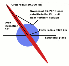
February 27, 2006: There are 24 GPS satellites, orbiting the Earth in 6 planes, each tilted 55 degrees from the equatorial plane. This means they can never reach zenith beyond a latitude of 55 degrees (Copenhagen, Cape Horn, Edmonton). When satellites are seen in the north in Sweden, they are just climbing above the horizon from the northern-most point of their orbits on the other side of the Pole, nowhere near zenith. The farther north you come in Sweden, the higher above the horizon these satellites from the "Asian/Pacific" orbits will reach. This would mean really bad reception when driving northbound and having the GPS receiver on the dashboard. One should rather put in in the rear window, or use an external antenna on the roof. Will this change in the European Galileo system?
February 26, 2006: Back to drawing the road to Murmansk again. Editing is smoother than ever, even at prime time in the early evening, but sometimes the tile server just dies, such as now 19:35 UTC. Then five minutes later, it's back alive again.
February 25, 2006: On the dev mailing list, Imi Scholz explains that OSM doesn't just support nodes and line segments, but also "ways", which can have attributes. This is really good news! How could I go so long without knowing?
February 24, 2006: The road riksväg 49 is drawn from Askersund over Olshammar, Karlsborg, and Tibro to Skövde, and riksväg 26 to Tidaholm, Mullsjö, and Jönköping. From there, E4 is now redrawn all the way to Linköping (cf. Feb 2), including all exits (except the one towards Gränna from the south).
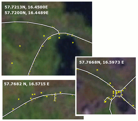
February 20, 2006: Following the success of WikiProject Småland, I launch a similar WikiProject Västergötland. When editing maps around Oskarshamn and Västervik, I find some really bad tracks, see the illustration below, screenshots from the editing applet at zoom=14. Errors show especially during turns. Who contributed these, and how can we improve the quality?
February 18, 2006: I challenge everybody to guess what this strange shape can be and when it was created. A rocket launch pad? A golf course? A royal garden?
- FrankM's guess was close. It's a housing area apparently built in 1973, in the city Alvesta in Sweden. The city planner must have had fun drawing this. About a dozen private homes are built inside a circular road, the same number on the outside, and five such circles. Straight streets form leaves at the bottom of the flower stalk (no tracks collected yet). The stalk and center circle is street Odlingsvägen, the circles are (clockwise) are Fjärilsvägen, Fuxvägen, Droskvägen, Ständvägen, the leaves are Åkarvägen, Ryttarvägen and Kuskvägen.
February 17, 2006: In the morning, Mikel fixes the bug behind ticket 134, making it possible again to view and edit maps, for the first time in two weeks. Before this, Mikel has installed a Squid for caching raw Landsat (NASA) satellite image tiles. The next few days I draw a maps of Kalmar, Nybro, Lenhovda, Blomstermåla, Högsby, Åseda, Alvesta, Ljungby, Värnamo, Lammhult, Vrigstad, Nässjö, Eksjö, Ekenässjön, Vetlanda, Bruzaholm, Ingatorp, Mariannelund, Vimmerby, Hultsfred, Målilla, Oskarshamn, Ankarsrum, Aneby, Tranås, Sommen, Boxholm, Västervik, Gamleby, Överum all part of WikiProject Småland. To my happy surprise, someone else (who?) had already contributed tracks for Blomstermåla and Mönsterås. With 2000 edits on Friday, 3197 on Saturday, and 3471 on Sunday I climb up the list of most active contributors, but there is no way I can threaten FrankM's leading position, as he makes 8000 edits on Sunday alone. - Two books arrive in the mail:
- Tyler Mitchell, Web Mapping Illustrated. Using Open Source GIS Toolkits, O'Reilly, June 2005, ISBN 0-596-00865-1
- Schuyler Erle, Rich Gibson, Jo Walsh, Mapping Hacks. Tips & Tools for Electronic Cartography, O'Reilly, 2005, ISBN 0-596-00703-5
Mitchell is a GIS specialist with a taste for open source software. He gives details on advanced software packages, such as the Minnesota MapServer. His book has the classic O'Reilly cover with a 19th century illustration of an animal. But "GIS" and "open source" is soo Web 1.0. The color cover and the word "hacks" in the title gives the other book a more updated look and feel, even though its contents is not as deep as Mitchell's.
February 13, 2006: Steve adds lists of the most active contributors (per day, week, and month) to the stats report.
February 12, 2006: For a short while on Sunday evening the website is working again, for the first time in ten days, but after midnight it goes back to the same random drop-outs (trac ticket 134 ) as the previous week. While it was possible, I was drawing roads from Kisa to Eksjö, Aneby, Tranås, and Boxholm. The road drawing in view mode has gotten better (trac ticket 133 ).
February 11, 2006: Another dry, cold winter day with nearly perfect road conditions. This Saturday I drove from Linköping, Riksväg 34 to Kisa, Vimmerby, Hultsfred, Målilla, Högsby, Riksväg 23 to Åseda, Växjö, Riksväg 25 to Ljungby, E4 to Värnamo, Riksväg 27 to Alvesta, Växjö, Riksväg 30 to Lammhult, Vrigstad, Jönköping, Riksväg 33 to Nässjö, Eksjö, Riksväg 32 to Aneby, Tranås, Boxholm, Mjölby, and E4 back to Linköping. The GPS receiver batteries went out just before Boxholm, so that's where the track ends. This track will be a great second installment to the WikiProject Småland that I started last week. Let's just hope somebody can fix the broken website, so I can draw the map from these trips.
February 9, 2006: We're creating and editing an ever larger Open Street Map, but is anybody using it? Is OSM just starting to become useful? I think OSM would benefit from feedback from actual users. So who could use it? Here are some suggestions:
- Fritz Ganter's GpsDrive [1] is a free software laptop/PDA Linux navigation system that uses raster maps only.
- Pascal Martin's RoadMap [2] is a free software laptop/PDA Linux navigation system that uses vector maps based on TIGER data for the United States and the (pretty useless, and semi-proprietary?) DCW (Digital Chart of the World, see Wikipedia) for the rest of the world. For Europe DCW contains a network of the major roads, and it shouldn't be long before Open Street Map can provide better data.
- Martin Schaller's and Horwitz' Navit [3] is a free software car navigation system for Linux with a routing engine.
- Stanislaw Kozicki's cGPSmapper [4] is a program that creates (compiles) maps for use on some Garmin GPS receivers. The source data is provided in the "Polish format" as described in the cGPSmapper User Manual (PDF). Users can upload their maps to the cGPSmapper mapcenter.
- For more free software, see Freshmeat's geographical category.
February 7, 2006: Some redesigns makes the OSM website useless for a few days. Tracklog dots are shown only randomly in the edit applet. Response times seem to be faster, but this could also be because most users are scared away.
February 6, 2006: A beautiful and cold winter Sunday, perfect for a trip into the new WikiProject Småland (its northeastern corner), with new tracks to be drawn: From Linköping, Riksväg 35 south to Åtvidaberg, Överum, E22 south to Gamleby, Västervik, Riksväg 33 west to Ankarsrum, Vimmerby, Mariannelund, Eksjö, Riksväg 134 north to Kisa, Riksväg 34 north back to Linköping.
February 2, 2006: The new tracks from Skaraborg-Närke-Västmanland are drawn, and I should continue here with all southbound exits on E4 Jönköping-Linköping.
 |
 |
January 31, 2006: I wrote a first draft of an introduktion på svenska, describing Open Street Map in a secret code language. - I also learned that there is a French project called Un Point C'est Tout, upct.org, founded in March 2004. See for example their road network of western France.
January 30, 2006: A weekend with good road conditions (no new snow) brought many new tracks: Jönköping, Falköping, Skövde, Skara, Götene (long time no see), Mariestad, Laxå, Örebro, Arboga, Kungsör, Hallstahammar, Köping, E4 (all exits southbound from Linköping to Jönköping), E20 (all exits southbound from Örebro to Viby), E18, Rv 36, 205.
January 26, 2006: I learned that Garmin StreetPilot 2650, 2660, and 7500 can do "dead reckoning" to compute their position even when they lose track of the GPS satellites, which can be very useful in inner cities and tunnels. This is based on a connection to the car's speedometer and an internal sensor for turns. Unfortunately, these units are "last year's models" with smaller screens and without the new SiRFStaar III chip. The newer Garmin nüvi 350 doesn't have the dead reckoning capability. Maybe some forthcoming nüvi model will? All TomTom GO models except the 300 have a similar feature called "Assisted Satellite Navigation" (ASN), which doesn't require any connection to the car's speedometer.

January 23, 2006: E4 is redrawn with short, parallel segments from Södertälje to Ödeshög, and covering every single exit from Södertälje to Linköping. For nice-looking maps of motorways with parallel carriageways, it is important that segment endpoints are placed perpendicular to the road, and that segments are short enough not to look edgy as the road bends and turns. To do this accurately, many tracklogs are needed for the same road. E4 was drawn early, before these conditions were met and these lessons learned, and needed to be redrawn. -- I now tend to simplify roundabouts as diamonds/squares. The most spectacular example is Roslagstull, Stockholm. A more typical example is found northwest of Nyköping.

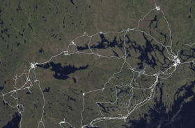
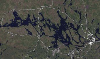
January 19, 2006: The contours of Mälardalen (valley around lake Mälaren, see screenshot) are starting to show with cities (clockwise) Stockholm, Södertälje, Mariefred, Strängnäs, Eskilstuna, Västerås, and Enköping.
January 17, 2006: Many new tracks: E18 Stockholm-Västerås, E20 Eskilstuna-Södertälje, Riksväg 50 "Bergslagsdiagonalen" Ödeshög-Motala, Riksväg 36 Motala-Borensberg, Riksväg 223 Mariefred-Nyköping, and parts of these cities. Maybe continue here.
January 13, 2006: Road to Murmansk is drawn south of 65.6°.
January 8, 2006: Ka-Ka's route is completed. Road to Murmansk is drawn south of 64°.
January 7, 2006: Ka-Ka's route is drawn south of 64.48°. Juve82 from Göteborg and Mikel from Brighton/Skellefteå join in, and we are now six known users in Sweden.
January 5, 2006: The road around lake Ladoga is drawn, and the road past lake Onega towards Murmansk is drawn south of 63°. There is now a WikiProject Sweden and a category:Users in Östergötland. Ka-Ka's inland route in northern Sweden is now drawn south of 63.46°.
January 1, 2006: Browsing through the proceedings of the 22C3 conference, which I didn't attend, I learned about the OpenTom project and registered a user page on their wiki. It turns out TomTom GO GPS receivers are based on Linux and the company was forced to open its source in order not to violate GPL, as Thomas Kleffel and Christian Daniel describe in their paper Hacking into TomTom Go. Reverse-Engineering des Embedded-Linux-Navigationssystems "TomTom Go". These people live near Würzburg, near Frankfurt/Main in southern Germany. See also the slides Reverse-Engineering eines Embedded-Linux-Systems am Beispiel TomTom Go from the November 2004 assembly of Kommunikationsnetz Franken (KNF-Kongress).
