Navit
| Navit | ||||||||||||||||||||||||||||||||||||||||||||||||||||||||||||||||||||||||||||||||||||||||||||||||||||||||
|---|---|---|---|---|---|---|---|---|---|---|---|---|---|---|---|---|---|---|---|---|---|---|---|---|---|---|---|---|---|---|---|---|---|---|---|---|---|---|---|---|---|---|---|---|---|---|---|---|---|---|---|---|---|---|---|---|---|---|---|---|---|---|---|---|---|---|---|---|---|---|---|---|---|---|---|---|---|---|---|---|---|---|---|---|---|---|---|---|---|---|---|---|---|---|---|---|---|---|---|---|---|---|---|---|
| License: | GNU GPL v2 (free of charge) | |||||||||||||||||||||||||||||||||||||||||||||||||||||||||||||||||||||||||||||||||||||||||||||||||||||||
| Platforms: | Windows, Linux, Android, Openmoko Linux, WebOS, n800, and zaurus | |||||||||||||||||||||||||||||||||||||||||||||||||||||||||||||||||||||||||||||||||||||||||||||||||||||||
| Version: | 0.5.7 (2026-02-08) | |||||||||||||||||||||||||||||||||||||||||||||||||||||||||||||||||||||||||||||||||||||||||||||||||||||||
| Language: | multiple languages
| |||||||||||||||||||||||||||||||||||||||||||||||||||||||||||||||||||||||||||||||||||||||||||||||||||||||
| Website: | https://www.navit-project.org/ | |||||||||||||||||||||||||||||||||||||||||||||||||||||||||||||||||||||||||||||||||||||||||||||||||||||||
| Install: | ||||||||||||||||||||||||||||||||||||||||||||||||||||||||||||||||||||||||||||||||||||||||||||||||||||||||
| Source code: | https://github.com/navit-gps/navit | |||||||||||||||||||||||||||||||||||||||||||||||||||||||||||||||||||||||||||||||||||||||||||||||||||||||
| Programming languages: | C and C++ | |||||||||||||||||||||||||||||||||||||||||||||||||||||||||||||||||||||||||||||||||||||||||||||||||||||||
|
Most popular open source car navigation tool; maps (offline-"custom"), vector-rendered | ||||||||||||||||||||||||||||||||||||||||||||||||||||||||||||||||||||||||||||||||||||||||||||||||||||||||
| ||||||||||||||||||||||||||||||||||||||||||||||||||||||||||||||||||||||||||||||||||||||||||||||||||||||||
Navit is open-source car navigation software capable of using (OpenStreetMap) OSM data. This project supports not just Linux desktop, but also a number of mobile devices, including the Nokia N810 Internet tablet.
- Project status
As of April 2023, the official website has no updates since 2021. However there is a low activity in source repo (mostly bugfixing and translating) and the contributors do answer on the GitHub issue tracker.
After a long period, a new stable release 0.5.7 has been published in February 2026.
Description
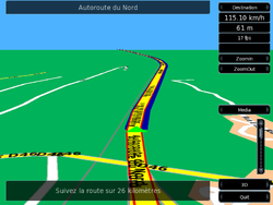
Navit uses a binary file format extracted from OSM map data, which it then renders in realtime. As well as being capable of search, routing and dynamic re-routing, it can also show maps in a three-dimensional bird's-eye view. See the project pages for further details.
How-to articles:
- How to use OSM maps in Navit
- How to use Navit and OSM on Ubuntu
- How to use Navit and OSM on Android
- How to use Navit and OSM on HTC Touch HD - WM 6.1
If you want to get help with Navit or before you file a bug, you should come to the Navit IRC channel. The developers are mostly active between 7 and 12 PM CET. The following mappers are involved in the development:
Screenshots
Features
- Display map (Layout)
- Map is rendered to vector format on the fly using raw data
- The user can define their own display styles using the navit.xml file. Every style can be build from scratch. As example, a user copied the mapnik style
- Navit can contain more than one style, and the user can change them. For example, when you drive a bike you aren't interested in parking places and fuel stations.
- Touting (Vehicleprofile)
- The user can create custom route profiles by giving a weight to each type of highway in OSM. This is sometimes tricky since other names are used in Navit. E.g. a
highway=track+surface=gravelis the type track_gravelled. Navit standard contains car, bicycle, foot and horse routing.- Supports offline routing
- The user can create custom route profiles by giving a weight to each type of highway in OSM. This is sometimes tricky since other names are used in Navit. E.g. a
- On screen display (OSD)
- Navit has a highly configurable OSD. The standard OSD configuration differs in each version of Navit (as can be seen on the screenshots above). The
OSD settings include:
- Compass
- Show current and next street name
- Show next turn and distance to it
- Show current speed, and GPS altitude
- Show distance and time to arrival
- Zoom and volume buttons
- All these options can be put in different areas of the screen with the map as background. The Navit wiki gives a very exhaustive list of things you can use in the OSD and in the menus.
- Search
- Search for country -> city -> street (street number search not working yet and is_in tags need to be provided)
- Get nearest POIs from a given point, the POIs can be viewed in categories.
- Set favourites to avoid search
- GPX trace:
- Navit can be configured to automatically store GPX traces of all your trips
See also
- Gosmore
- wikipedia:Navit
- BBBike.org extract service offers Navit maps for an area of your choosing, updated weekly


