JA:Navit
Jump to navigation
Jump to search
| Navit | |
|---|---|
| ライセンス: | GNU GPL v2 |
| 動作環境: | Windows、 Linux、 iPhone、 Android、 Openmoko Linux、 WebOS、 n800 および zaurus |
| 版数: | 0.2.0 (2013-01-13) |
| 言語: | 43
|
| ウェブサイト: | http://www.navit-project.org |
| ソースコード: | https://navit.svn.sourceforge.net/svnroot/navit |
| プログラミング言語: | C および C++ |
|
Most popular OpenSource Car navigation tool; maps (offline-"custom"), vector-rendered | |
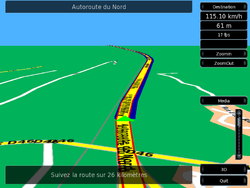
Navitは、OSMデータを使うことが可能なオープンソースのカーナビソフトウェアです。このプロジェクトは、linuxデスクトップだけでなく、Nokia N810インターネットタブレットなどを含むいろいろなモバイルデバイスをサポートします。 このプロジェクトは、OSM地図データから抽出したbinfileフォーマットを使い、リアルタイムに描画されます。探索、ルーティング、動的リルーティングが可能であることに加え、地図を3D鳥瞰図として表示することも可能です。より詳しい情報については、プロジェクトページを参照してください。
- Navit website : http://www.navit-project.org
- Navit wiki http://wiki.navit-project.org/index.php/Main_Page
- How to use OSM maps in Navit [1]
- HowTo Navit and OSM on Ubuntu
- HowTo Navit and OSM on HTC Touch HD - WM 6.1
- HowTo Navit and OSM on Android
Navitについて何か質問がある場合、あるいはバグを報告する際は、まずは次のリンク先をご覧ください: Navit IRC channel 開発メンバーの活動時間は、通常7PM~11PM CET(Central European Time 中央ヨーロッパ時間)です。開発に携わっているマッパーは以下のメンバーです:
Screenshots
features
- display map (Layout)
- map is rendered to vector format on the fly using raw data
- the user can define his own display styles using the navit.xml file. Every style can be build from scratch. As example, a user copied the mapnik style
- The Navi can contain more than one style the user can change them. For example when you drive a Bike you arn't interested in parkingplaces and fuelstations
- routing (Vehicleprofile)
- the user can create custom route profiles by giving a weight to each type of highway in OSM. This is sometimes tricky since other names are used in navit. e.g. a
highway=track+surface=gravelis the type track_gravelled. Navit standard contains car, bicycle, foot and horse routing.- supports offline routing
- the user can create custom route profiles by giving a weight to each type of highway in OSM. This is sometimes tricky since other names are used in navit. e.g. a
- On Screen Display (OSD)
- navit has a highly configurable OSD. The standard OSD configuration differs in each version of navit (as can be seen on the screenshots above). The
OSD settings include:
- compass
- show current and next streetname
- show next turn and distance to it
- show current speed, and gps altitude
- show distance and time to arrival
- zoom and volume buttons
- All these options can be put in different areas of the screen with the map as background. The Navit wiki gives a very exhaustive list of things you can use in the OSD and in the menus.
- search
- search for country -> city -> street (streetnumber search not working yet and is_in tags need to be provided)
- get nearest POIs from a given point, the POIs can be viewed in categories.
- set favourites to avoid search
- GPX trace:
- Navit can be configured to automatically store GPX traces of all your trips
See also
- Gosmore
- wikipedia:Navit
- BBBike.org extract service offers navit maps for an area of your choosing, updated weekly


