Community Updates/2010-10-04
Community Update From 04 October 2010 to 10 October 2010
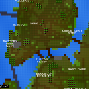
Image Of the Week
An 8bit-game-like map of New York City based on OSM data. http://8bitnyc.com/
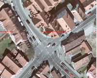
Project of The Week : Crossroad Mapping
How well mapped are the crossroads near you? Have you included sidewalks / pavements, pedestrian crossings, traffic_signals, turn restrictions, accessibility details of the crossings, like tactile pavement and audible beacons? Have you included block addressing or spot addressing for the Points of Interest near the intersection?
News
- New offline map display and routing for iPhone: ForeverMap
- New tag listing/stats website: Taginfo (see below)
- Typographic Map posters made with openstreetmap
Mailing Lists
GreenField / BrownField
landuse=greenfield is described on the wiki as an area scheduled for new development where there have been no buildings before, and landuse=brownfield as land scheduled for new development where old buildings have been demolished and cleared. Differences are not clear for everyone and the use of landuse=greenfield is quite controversial. In fact some people thinks it'd be better to have nothing until the construction start and only then put a tag landuse=construction.
RFC: Traffic Speed
Traffic speed is a new proposed relation to store the average traffic speed on a road. This relation, could use time based values to describe the usual speed. An example would be "motorcar:forward=Mo-Fr 08:30-9:30 8mph"
Comments are welcome on the Talk Page
RFC: Heritage
Some time ago, the new proposal about site or building registered by an official heritage organisation has popped out on the wiki, but was not advertised. Now it's done : Request are welcome on Talk:Proposed features/heritage. This new tag "heritage=*" aims to replace the previously proposed historic=heritage or the historic=unesco_world_heritage.
Overtaking New on Map Features ?
This week someone added, without consensus, a new tag to Map Features. In fact this tag is not a new tag and has been described a year from now. overtaking=* is in fact a way to tag a portion of a road where overtaking is allows or disallowed. Discussions on the lists started again about the utility of this tag and the way it was added to Map Features.
RFC: Winter Road
A new proposal has been made to handle "winter roads". These road are used only during the winter season, and are often completely impassable during warm season. They would be tagged as surface=winter_road.
Comments are welcome on Talk:Proposed features/surface:winter road.
Taginfo a new usefull tool !
TagInfo (taginfo.openstreetmap.de) has been announced on the mailing list. This new tool provide statistics about tag usage across the globe. It's built as another alternative to the older Tagwatch, Tagstat, and OSMdoc tools. How much is X or Y used?, what are different values for tag Z?, which wiki page describe tag W? For these kinds of questions check out TagInfo. It's open source and available on github.
highway=incline Deprecated
highway=incline and highway=incline_steep has been marked as deprecated. Please use incline=* tag instead. highway=incline was previously used to describe a way going uphill or downhill. Now incline=* allows mappers to describe an incline as value (in %) or with a fuzzy attribute (up / down).
Discussions about Land Use and Land coverage
Someone started a discussion about creating a "new" tag landcover=* that will solve problems of landuse=*. In Fact, "landuse" tags sometime describe a "use" (farm,...) of the land, and sometimes a "coverage" (forest,...). Some people want to use surface=* to do that job.
More. See also Land use and areas of natural land for open questions around landuse/natural area mapping
Thanks
Thanks to Stephan75 for news hints on the Draft page.

