Malaysian Roads Tagging
| Sabah and Sarawak mappers? Feedbacks are welcome! |
| Further questions? Discussions? Head to the forum (or the discussion page)! |
This page merely recommends how to tag highway=* in Malaysia (note: strictly the peninsular at the moment). Over time, different mappers will have their own way to interpret a certain tag, but definitely, some key-value pairs will become the standard way to tag things.
The main classification for Malaysian highways are as follows:
- Expressways (Lebuh Raya Ekspres)
- Federal roads (Jalan Persekutuan)
- State roads (Jalan Negeri)
Other types of roads may not fall under any kind of the mentioned categories, but they are able to be systematically tagged in the OSM database according to their primary function and/or importance to local traffic. The ref tags listed on signs do not delineate between ref and ref:to markers. In order to determine how to tag the ref network, mappers should look at the larger road network before tagging.
Attention Organised Editing Teams
Remember local craft mappers are humans too - these people may make mistakes. However, please, please, with cherry on top, analyse for any possible recent edits of their work before straight into making any changes. Check for any history of edits in the JOSM editor (Ctrl or ⌘ Cmd and H). Unless more concrete evidences, especially from KartaView, Mapillary or likewise, are made available; try not to discard any likely recent ground truth observations.
Carriageways demystified
- For more details on this topic, see Dual carriageway.
Should highways be mapped as undivided (single carriageways)? Or otherwise (multiple carriageways)?
Refer to the following diagram on the right.
In short: no physical divider, no need to trace separate highway. This is not a Malaysia-specific policy.[1]
| Case | Divided highway? |
|---|---|
 |
yes |
 |
no |
 |
no: painted barriers are not physical barriers |
 |
no |
 |
yes: traffic delineators are fixed to the ground |
 |
yes: only for the link highway with the give way sign |
 |
yes: don't forget to map the tree, growing in the middle of the divider |
 |
no: painted chevrons are not physical barriers, use lanes=* instead |
 |
yes |
Expressway
The highway system which is the highest class in Malaysia.
| Reference number
Highway shield |
OSM tagging
Typical examples |
Description, comments | Photo | |
|---|---|---|---|---|

One or two digits, beginning with the letter E |
highway=motorway |
Exceptions:
|

| |
|
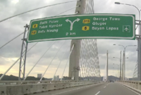
highway=motorway_link
destination=* |
|
 [1] Alternate ref signage sometimes seen. Imagery found on Mapillary. |
 [2] New version of this type of signage. Imagery found on Mapillary. |
| highway=path |
|

|
Further reading
Federal roads
These highways are maintained under the Ministry of Works (MoW or KKR). Features blue road signs.
| Reference number
Highway shield |
OSM tagging
Typical examples |
Description, comments | Photo |
|---|---|---|---|
 
Main Federal Road One or two or three digits |
highway=trunk |
Semi-expressways
|

|
| highway=primary |
Main roads
|

| |
| highway=* |
Other main roads Some roads in certain places (e.g. Langkawi or Selangor) may not be suitable to be tagged with highway=trunk or highway=primary. Use highway=secondary or highway=tertiary to accurately reflect the importance of such roads. |
N/A | |

Institutional Federal Roads Three digits |
highway=* |
|
N/A |

FELDA or FELCRA Federal Road Four digits, beginning with 1000-2999 |
highway=* | N/A | |

Industrial Federal Roads Four digits, beginning with 3000-3799 |
highway=* | N/A |
Note
- Major federal route, for example, Federal Route 1, is usually referred as a federal trunk. However, as it winds through small cities or towns or rural areas (e.g. outside Greater Kuala Lumpur or Johor Bahru), the route may show clear signs not fully meeting the conventional highway=trunk criteria. highway=primary tag (or lower tag classifications) describes better this particular stretch of road. This may apply to the rest of major federal routes (which usually has a single digit reference number). Divided stretch (dual carriageway), or an undivided stretch (single carriageway) does not directly imply whether it should be tagged as highway=trunk or highway=primary – consider access control. To discuss more in depth, the forum is the best place to do so! Important: do not simply tag for the renderer.
- Currently the road reference system can be said quite messy. The last time the road list was updated in 2013, the main federal routes are coded with 1-255 and institutional roads are coded with 250-499. However, recently, some of the formerly state roads were made into roads maintained under the federal level (MoW) and are using codes meant for institutional road.
Major federal routes suitable to be tagged as a highway=trunk
- The Federal Highway, route number 2
- The Pan-Borneo Highway when it's completed
Further reading
- Malaysian Federal Roads System (Wikipedia)
- List and map of the Malaysian Federal Route (official website) - says it was last updated 1 June 2015 but still holds the outdated information.
State roads
Roads connecting towns, districts or villages in a state. Maintained under the state's Public Works Department.
| Reference number
Highway shield |
OSM tagging
Typical examples |
Description, comments | Photo |
|---|---|---|---|

One or two or three digits, beginning with specified letters for each state |
highway=* |
The main function of the road can be considered to decide the class of a state road. For example:
Please note that some residential roads may look the same to these kind of road, however, there is a specific tag for that. In short, universal tag convention gives the best description. |

|
State road codes
|
|
Sarawak uses ![]() Qxxx prefix[2]; while federal routes in Federal Territory Labuan has
Qxxx prefix[2]; while federal routes in Federal Territory Labuan has ![]() Lxxx prefix[3]. Sabah does not use any state prefixes[2].
Lxxx prefix[3]. Sabah does not use any state prefixes[2].
Kuala Lumpur Federal Territory allegedly uses W prefix, however on the ground rules apply. No offical signages, so nothing.
Further reading
Malaysian State Roads system (Wikipedia)
Other roads
| Sample signpost | OSM tagging
Typical examples |
Description, comments | Photo |
|---|---|---|---|

|
highway=* | Maintained by local authorities (majlis bandar raya or majlis perbandaran). This kind of road is typical, for example, in Shah Alam (with BSA code followed by a number). Again, the degree of importance of the road depends on its traffic, etc.
More about its road code over here. |
N/A |

|
highway=unclassified | Roads with no certain classification. These may include:
These kind of road act as feeder roads, which means they mainly carries traffic from villages (or special residential areas) to a major road. |

|

|
highway=residential | Roads in a typical housing estate (taman perumahan). May also be used in villages (or any other kind of residential areas) upon roads that act as feeders to the more important local highway. | 
|

|
highway=service | Provides access to parking spaces, fuel stations, buildings, etc. | 
|

|
highway=track | The bottom class of the road network which is still accessible by cars (or probably four-wheeled drive only). The tag can describe the tracks in agriculture lands or the only way deep in remote areas. | 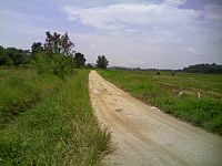
|

Signposted motorcycle lane in expressways

Signposted bicycle lane
|
highway=path | Used for roads totally inaccessible by any four-wheeled vehicles. Motorcycles may or may not be able to use it. | 
|
| N/A | highway=pedestrian | As shown in the picture to the right (Kuala Lumpur Central Market), the road is open for pedestrians only. No vehicles is allowed on the road. | 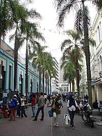
|
| highway=footway | N/A | ||
| highway=living_street | |||
| Example based on 560371536 |
highway=motorway_link |
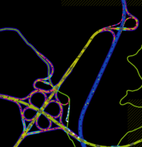
| |
| Example based on 249848185 |
highway=motorway_link destination:ref=* |
Often times there is no clear difference between the destination:ref and destination:ref:to signs for motorways and links. Look at the larger road network to see which refs connect directly to a link. | 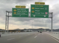
|
Notes
- The road Lebuh AMJ is an abbreviation commonly used on a road running from Simpang Ampat to Malaaca City before going west-east from Malacca City to Muar. The less commonly used expanded form is Lebuhraya Alor Gajah–Melaka Tengah–Jasin.
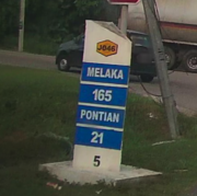
Route reference number
These can be found in direction signs or mile markers: the route reference number is in hexagonal highway shields (![]() )
)
| Sample street furniture | OSM tagging |
| ref=1
N.B. | |
| ref=J7 name=Jalan Gelang Patah - Ulu Choh
| |
| ref=K1 | |
| Painted reference number on road surface
|
See also
- Highway classification in Thailand
- Highway classification in Singapore
- Highway classification in Indonesia
External links
References
- ↑ Mapping and improving map data in Bangkok - case 9
- ↑ 2.0 2.1 KENALI JALAN RAYA SIRI 3 memaparkan contoh kod nombor Jalan Negeri mengikut negeri-negeri di Malaysia. Seperti Perlis (R1), Kedah (K8), Kelantan (D6), Johor (J17).
- ↑ KENALI JALAN SIRI 2 pula memaparkan kod nombor Jalan Persekutuan mengikut negeri-negeri di Malaysia.


