Mountain biking

|
| Description |
| Mountainbiking routes |
| Tags |
The goal of this page is to help create OSM maps from a mountain bikers perspective. This page began as a translation of the German version.
| Key | Comment |
|---|---|
| highway=path/track | if a way is tagged highway=footway and mtbiking is allowed, considering using highway=path + foot=designated + bicycle=yes/designated |
| foot=yes/no/designated/private/permissive/destination/unknown | - |
| bicycle=yes/no/designated/private/permissive/destination/dismount/unknown | Is cycling allowed? This is only a legal question. |
| width=<Meter> | Width of way |
| oneway:bicycle=yes/no | Where signposted as oneway only. If bicycles are the only mode permitted then you could use oneway=yes/no, if other modes are permitted and the oneway only applies to bicycles then use oneway:bicycle=yes/no. |
| surface=ground/sand/stone/gravel/grass/dirt | Material of the trail or road surface |
| smoothness=excellent to impassable | Classification scheme regarding the physical usability of a way for wheeled vehicles. |
| tracktype=grade1 to grade5 | Surface firmness, usually used on highway=track. |
| trail_visibility=excellent/good/intermediate/bad/horrible/no | Trail visibility (not route visibility) and orientation. |
| Key | Comment | Proposal/map feature page | Status/progress |
|---|---|---|---|
| mtb:scale=0-6 | Difficulty grading for mtb use for level and downhill trails, also valid for ways that are no singletrails. Based on the German "Singletrailskala". | key:mtb:scale | Approved |
| mtb:scale:imba=0-4 | Difficulty grading for mtb use for built tracks. Mainly applicable to North America. | key:mtb:scale | Approved |
| mtb:scale:uphill=0-5 | Difficulty grading for mtb uphill use. Use if there is a significant inclination. | key:mtb:scale | Approved |
| incline=<incline in %> or up/down | How steep is a trail. Please use this tag in conjunction with mtb:scale:uphill to specify direction of way (uphill vs downhill). | Key:incline | Approved |
| mtb:type=crosscountry/allmountain/downhill/trial/freeride | Giving further Attributes to a trail from mountain biking perspective. Classify its usage. | Proposed features/mtb:type | See commonly used values taginfo |
| mtb:description=any | Any Additional information related to mtbike use of a way. | Proposed features/mtb:description | Approved |
| mtb:name=any | Sometimes trails have names that are only used by mountainbikers and not official. Use mtb:name to specify them. This is not Key:loc_name | ||
| aerialway:bicycle:=yes/summer/no | Specify if bicycles are transported on aerialways. Use value summer if bicycles/mtbikes are only transported during summer season. Most chairlifts and t-bars don't allow for bicycle transport, but some add hooks for bicycle transport. | Proposed features/Piste_Maps |
Relevant proposals that can accompany mtb tagged trails
| key | comment | needs proposal | Status/Progress |
|---|---|---|---|
| tourism=information information=map |
Information point with map of trails, typically found at the trailhead. | Proposed features/information | Disputed use of access tags to describe object (see talk page), inactive but in use |
| tourism=information information=guidepost |
Information point with direction signs. | Proposed_features/Guidepost | |
| osmc:symbol=* | Notation system for trail symbols | Key:osmc:symbol | |
| trailblazed=yes | A way is marked with trailblazes (way markings) | Proposed features/trailblazed |
The above keys seem to be in use but keep track of eventual changes, they are indicated here to point out details that are very relevant to note while surveying, and a temporary tagging scheme allow us to store it.
Additional tags if a way is part of a MTB route / relation
Note a specific network=* is not defined for mtb routes, however, in several countries the normal bicycle network tags network=lcn, network=rcn and network=ncn are used to distinguish types of routes. Use distance/ascent/descent/roundtrip instead to better classify a route.
| Key | Comment |
|---|---|
| route=mtb | consistency with cycle and hiking routes. |
| ref=R811,... | Reference of the way if any. |
| name=Alpentour Austria,... | name of the route. |
| distance=distance in km | The distance covered by this route, if known. For information of users and automatic evaluation e.g. of completeness. If no unit is given km is assumed (else use e.g. 25miles) |
| ascent=ascent in m | The ascent covered by a route in meters (for other units use e.g. 600feet). If a route has start and end point at different altitude use descent too |
| descent=descent in m | The descent covered by a route in meters(for other units use e.g. 100feet). Use it only if it differs from the ascent (different altitude at start/endpoint of a route). |
| roundtrip=yes/no | Use roundtrip=no to indicate that a route goes from A to B, instead of being circular (roundtrip=yes). |
You can create your own maps including route=mtb for Garmin Units/Mapsource or Qlandkarte GT by following the procedure explained here however: OSM Map On Garmin/mtb map.
How to tag ways appropriate for mtbiking
JOSM now includes mtb:scale in the presets for paths and tracks. For incline and mtb:scale:uphill; mtb:description; mtb:scale:imba or others, you can add the keys and values by clicking on "add". For keys that are not available on a preset you can either add a mtb preset from here: http://josm.openstreetmap.de/wiki/Presets or directly entering the information by clicking on "ADD". Here is a list of presets specifically created for MTB:
- MountainbikeTrails: Additional presets for Mtbikers
- MTB Tagger: MTB-specific tagging of ways
- MtbSingletrack: Comprehensive presets for MTB trails
JOSM Example:

With Potlatch after selecting a way click on the "+" icon:

And then replace key with the respective key, and enter the value into the gray type value here

Rendering of MTB maps

- Technical information about rendering Shaded_relief_maps_using_mapnik
- Orienteering Map Specifications, including MTB-O
Online routing using MTB information
- On OpenRouteService (website) you can route from A to B with preference for mtb trails and routes.
- Brouter (web version) lets you build custom routing profiles that take e.g. mtb:scale into account.
- Komoot uses openstreetmap data, including mtb:scale, to evaluate difficulty of routes (see e.g. this description and this instruction).
Online maps showing MTB information
- UtagawaVTT has a map to display trails and locations where MTB is forbidden or not recommended : MapUtagawa.
- Waymarked Trails has nice rendering for mtb routes, including elevation profiles and sections. Reflects changes to OSM within minutes.
- CyclOSM (website) renders road, path, track surfaces quality, MTB scales, MTB routes, relief shading, etc.
- mtbmap.org: renders trails using mtb:scale and mtb:class on hill shaded background. Covers only Norway, Sweden, Denmark.
- VTTrack implements the MTB features on various underlying maps (OpenStreetMap, GoogleMaps, French Geoportail maps). It also includes other sources of MTB tours and trails, especially other sources whose tour/trail rating scale is mappable onto mtb:scale (UtagawaVTT.com, VTTour.fr, Singletrack.fr, Gulliver.it, cycloalpinismo.com).
- Mtbmap.cz rendering of both MTB features together with specific hiking trail markings (red/green/blue/yellow) in the Czech Republic, with the aim to generate maps comparable to the printed maps generated according to the Czech cartography standards. It also renders MTB features and supports rendering hiking trails using WayMarkedTrails overlay for the rest of Europe (overlay can be enabled via layers menu in the top right corner of the map). In the Czech Republic, the map also supports complex planning and optimization MTB trips (dynamic specification of preferences for various types of trails and roads) with generation of altitude profiles.
- 4UMaps implements MTB as well as hiking features. The map is optimized for outdoor activities with elevation lines, hill shading, accommodation etc. A free download of predefined maps is also available.
- MTB trails with altitude profiles, routing capabilities and GPX export: www.xctrails.org
Rendering of MTB maps on Garmin units
You can download routable mountainbike maps for European countries, Alps, Australia/NewZealand, South America and Africa on Openmtbmap.org The maps support autorouting with preference for mtb trails and cycleways, and give visual display of mtb:scale; mtb:scale:uphill (taking incline into account for "downhill arrows") and route=mtb.
You can also create your own maps using mkgmap.
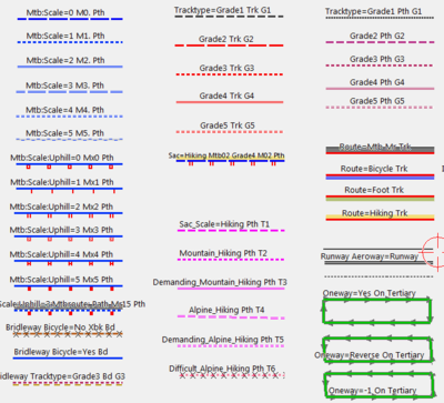
Map Legend in Mapsource
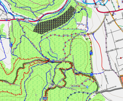
Example Area Anninger Moedling


UtagawaVTT has a free Garmin map available for most of European countries showing tracks and path forbidden or not recommended for MTB : MapUtagawa.
Rendering on Android devices
Openandromaps provides vector maps and themes for MTB, hiking and biking. These can be used with Oruxmaps[1] or Locus[2] and provide information about mtb:scale and mtb:scale:uphill. The maps are in the mapsforge format and can also be used with other applications using implementing this format.
| Map legend | Example |
| Official MTB-Routes color codes for mtb:scale ••••••••• Brown: mtb:scale_0 or no mtb:scale tagged in OSM MTB:SCALE Color codes of highway=path|footway|track MTB:SCALE:UPHILL |

|
- Proposed features/mtb:type provide the general usage class of a trail. I.e. cross country, all mountain, downhill, freeride, north shore, etc.
- Proposed features/mtb:scale approved proposal (provide a classification scale to mountain bike difficulty trails, for going downhill)
- Proposed features/mtb:description approved proposal (provide any additional public information about a mountain bike trail)
- Proposed features/Tag:path=mtb proposal to distinguish paths constructed as or in use as specifically mountain biking paths.
See also
- Portal for listing mountainbiketours on OSM: Mountainbiketours
- Portal for Cycling: Bicycle
- Hiking
- Climbing and Hiking (English): Approved features/Hiking
- Highway=path Examples: Tag:highway=path/Examples
- shop=outdoor
mtb:sales=*, mtb:parts=*, mtb:clothes=*, mtb:shoes=* - mtb=* access tag