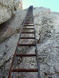
Tag:highway=via_ferrata
| Description |
|---|
| A mountain route equipped with fixed cables, stemples, ladders, and bridges where climber is attached to supporting equipment limiting fall. |
| Group: highways |
| Used on these elements |
| Useful combination |
| Status: in use |
| Tools for this tag |
|
Use highway=via_ferrata to represent a ![]() via ferrata ('steel path'; in German speaking countries: Klettersteig) for traversing a mountainside. Usually very exposed and gear required.
via ferrata ('steel path'; in German speaking countries: Klettersteig) for traversing a mountainside. Usually very exposed and gear required.
See Proposed features/via ferrata for details of mapping.
Although the proposal was heavily disputed, this tag and the related via_ferrata_scale=* is already in use for some years and several renderers such as OpenAndroMaps and OsmAnd support it.
Relations of type route=via_ferrata have been proposed for more complex situations.
There is some overlap between ferratas and highway=path with Safety measures on hiking trails and some elements from both proposals can be mixed.
How to map
Draw a way and tag it with highway=via_ferrata. In rare cases when the ferrata is extremely steep it can be drawn as a single node.
Add via_ferrata_scale=* and details along the way such as
- bridges, usually bridge=yes+bridge:structure=simple-suspension+cable_number=*
- ladder=yes
- rungs=yes
- overhang=yes
highway=via_ferrata implies wheelchair=no and unsuitability for bicycles, horses and vehicles.
If the via ferrata is walkable without special equipment by experienced hikers add a corresponding difficulty level as sac_scale=*. In this case highway=path may also be used as main tag, depending on which use is prevalent.
Details along the way
Those tags have to be added to the main one if used, i.e. they shall not be used alone for themselves. Some are already approved; hence they are part of this proposal as an extension use
| Key | Value | Element | Comment | Example |
|---|---|---|---|---|
| bridge | yes | An unspecified bridge type along the via ferrata route | ||
| bridge:structure | simple-suspension | "Tibetan" or other very simple hanging/swinging bridges including 2 or more rope bridges see bridge:structure=simple-suspension for more details | ||
| cable_number | 2 or more | For cable bridges the total number of cables, in addition to bridge=yes and bridge:structure=simple-suspension | (here a 3 cable bridge) | |
| aerialway | zip_line | A zip line along the via ferrata route see aerialway=zip line | ||
| oneway | yes | If the via ferrata is not allowed both ways | ||
| ladder | yes/length in m | Steel ladder, see ladder=* | ||
| rungs | yes/amount | Rungs, stemples, pins | ||
| tunnel | yes | A tunnel along the via ferrata route | ||
| natural | cave | Via ferrata route through a cave (see proposal natural=cave) | ||
| overhang | yes/no/ length in m | Overhanging sections of significant length |
Seasonal Access
Some ferratas are seasonally closed due to a variety of restrictions (wildlife, snow/ice, etc.). These restrictions are typically posted on physical signs in the vicinity of the respective ferratas.
As used for other ways and relations, access:conditional=* in conjunction with the opening_hours=* syntax can be used to map such restrictions. Placing such a restriction should explicitly mention foot, especially where foot is already in the tags, e.g. foot=yes; foot:conditional=no @ (Nov 1-Apr 30) will help prevent unsuspected surprises.
Alternatives and history
For walkable (without a ferrata set) paths with an additional security rope or other security elements, see the approved proposal Safety measures on hiking trails. The distinction is largely by designation, difficulty and actual usage - do people use ferrata gear there? Paths by default do not imply anything about usability and access for horses, bicycles etc which should be tagged additionally.
Before highway=via_ferrata was proposed, various methods were in use – some of which remain in widespread use until now. sport=via_ferrata was the earliest known proposal (see Proposed features/via ferrata version 1). While sport=via_ferrata is rarely used today, it might have some utility if it would be defined to have a meaning like other contemporary sport tags. After the sport=ferrata proposal was inactive, highway=path in combination with various tags that would declare the path to be a ferrata became the method of choice and as of May 2019 almost half ferratas are still mapped as highway=path+via_ferrata_scale=* (although the numbers should be used with caution as a significant share of objects mapped with either method may be actually hiking paths with additional security features). Historically, there were tags such as ferrata=yes which would make a path into a ferrata. In March 2019 a proposal for this method was launched (see Via Ferrata Simplified) which was abandoned after not receiving support during the RFC.
Proposed features/via ferrata introduced highway=via_ferrata and the issue of using highway=path vs highway=via_ferrata was heavily disputed. Currently, mapping of ways which can be used as either hiking path or a ferrata with highway=path + via_ferrata_scale=* + sac_scale=* seems acceptable (as long as the hiking difficulty fits into the range covered by sac_scale). The combination of highway=via_ferrata + via_ferrata_scale=* + sac_scale=* would be also acceptable for this purpose. On the other hand mapping of ferratas not suitable for hiking as highway=path for the purpose of having them rendered in some of the few renderers not supporting highway=via_ferrata could be considered troll tag and mapping for the renderer.
Renderer support
Offline maps
- OpenAndroMaps and render theme Elevate, e.g. in Locus
- OsmAnd
- Trekarta (formerly MapTrek)
Online maps
See also
- (approved) Proposed features/Safety measures on hiking trails
- climbing=* - mapping of climbing routes
- Hiking
- assisted_trail=* - dangerous or difficult sections of a hiking path are secured by technical means


