Template:Hu:Map Features:cycleway
Jump to navigation
Jump to search
Kerékpárút
A 'cycleway' címke egy kerékpárút vagy -sáv sajátos jellemzőinek leírására szolgál, amikor a kerékpárút osztozik más közúti elemekkel (például járda, úttest, stb.). A highway=* címkével együtt használandó.
| Érték | Alapelem | Magyarázat | Fotó | |||
|---|---|---|---|---|---|---|
Dedicated bicycle lanes | ||||||
| lane | Kerékpársáv: egy olyan útvonal, amely az úttesten halad. | |||||
|
| ||||||
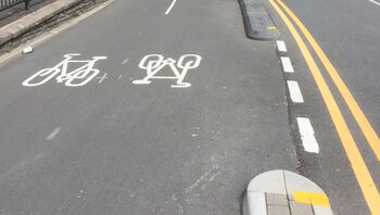
| shared_lane | Cyclists share a lane with motor vehicles, and there are markings (like The road markings are usually there to highlight a cycle route or to remind drivers that you can cycle there. |
|||||
| share_busway | A special lane reserved for public transport on which cyclists are also allowed to bike. | |||||
Bicycle tracks | ||||||
| track | Kerékpárút: egy olyan útvonal, amely az úttesttől különválasztott. Ez az érték felesleges (a highway=cycleway vagy a highway=path használandó helyette). | |||||
| separate | Should be used to indicate that a cycle track associated with a highway has been mapped as a separate OSM element (i.e., is tagged with highway=cycleway). Meaning is similar to the use of sidewalk=separate for footways, and can potentially be used when simplifying geometries for rendering. It also acts as a hint to avoid duplicating an existing cycleway by adding cycleway=track to a highway. Don't confuse with segregated=yes. | |||||
No bicycle infrastructure | ||||||
| no | Explicitly marks that a street has no bicycle infrastructure. This allows to explicitly note that the road was surveyed for bicycle infrastructure. | |||||
Other bicycle infrastructure | ||||||
| crossing | Used on separately mapped paths to indicate that it's a bicycle crossing. | |||||
| shoulder | Used to indicate that a road has no designated infrastructure for cyclists, but shoulders (a.k.a. breakdown lanes) are navigable and legal to cycle on. Especially on rural roads with high speed limits, the existence of a shoulder usable by cyclists can make the difference whether the road is usable at all (semi-)safely for cyclists. Not every shoulder=* is automatically usable for cyclists: Some shoulders are used for parking (parking=shoulder) instead, not all shoulders are paved (with asphalt, e.g. grass pavers). Additionally, shoulder=yes is typically only mapped for shoulders that are broad enough to accommodate a car. For cyclists however, a less wide shoulder is fine, too. | |||||
| link | A connector between OSM segments for cycle traffic, for example to connect a separately mapped cycle path to a junction on the opposite side. Serves primarily as a routing aid and does not necessarily have to be identifiable as built infrastructure. | |||||
| traffic_island | Used on the parts of refugee islands of a cycleway=crossing. | |||||
| asl | Indicates an advanced stop line or bike box at junctions. Use cycleway=asl on a |
|||||
Deprecated or discouraged tags | ||||||
| Ellenirányú kerékpárforgalom: engedélyezett ellenirányban kerékpározni, de nincs külön sáv (egyirányú utca kivéve kerékpárral). | ||||||
| Formerly used on cycleways which were mapped as separate ways tagged as highway=cycleway before the segregated=* tag was formalized. Its use with highway=cycleway is now considered obsolete. | ||||||
This table is a wiki template with a default description in English. Editable here.
A táblázat fordítását ezen az oldalon szerkesztheted.


