File:Managua bus users map.jpg
Jump to navigation
Jump to search


Size of this preview: 800 × 533 pixels. Other resolutions: 320 × 213 pixels | 640 × 427 pixels | 1,024 × 683 pixels | 1,280 × 853 pixels | 2,560 × 1,707 pixels | 5,184 × 3,456 pixels.
Original file (5,184 × 3,456 pixels, file size: 7.6 MB, MIME type: image/jpeg)
Summary
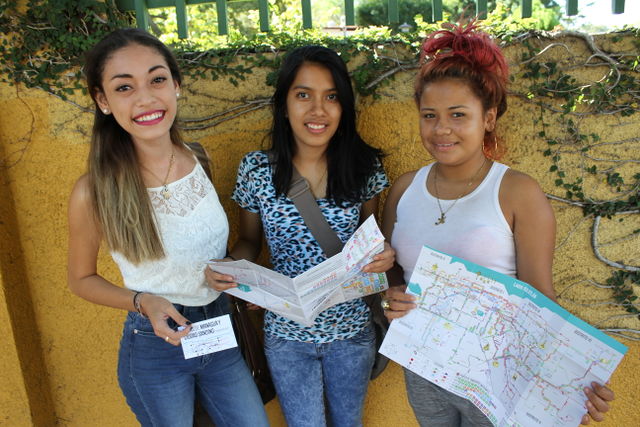
Managua bus users showing OSM based paper map of public transportation network. First map of its kind in an Central American capital.
Foto shared by User:Xamanu und CC-BY 2.0 license. Sourceː https://www.flickr.com/photos/xamanu/24153568483/in/album-72157664081295871/ [ dead link ] Read more about the contextː http://confidencial.com.ni/the-true-geographers-take-the-buses/
This is a Featured image, which means that it has been identified as one of the best examples of OpenStreetMap mapping, or that it provides a useful illustration of the OpenStreetMap project. If you know another image of similar quality, you can nominate it on Featured image proposals.
Front-page image for week 25 of 2016 (20–26 Jun.).
- Image descriptions
- English : A bus map produced with OpenStreetMap, is now being used and enjoyed by the people of Managua, Nicaragua. This article tells the story.
- italiano : Una mappa degli autobus prodotta con OpenStreetMap viene usata e goduta dalla gente di Managua, Nicaragua. Questo articolo ne racconta la storia.
- русский : Автобусная схема на этой фотографии сделана с применением данных ОСМ. Картой пользуются счастливые жители города Манагуа (столицы Никарагуа), а история проекта попала в местное СМИ.
- 中文(简体) : 如今尼加拉瓜马拿瓜的人使用而且相当喜爱用开放街图资料制作的公车地图这篇文章说明这个故事。
- 中文(繁體) : 如今尼加拉瓜馬拿瓜的人使用而且相當喜愛用開放街圖資料製作的公車地圖這篇文章說明這個故事。
- فارسی : نقشه خطوط اتوبوسرنی تهیه شدهبا OpenStreetMap ،حالا توسط مردم Managua در Nicaragua استفاده میشود و از آن لذت میبرند. این مقاله از داستان است.
Licensing
![]()
![]()
![]()
This work is licensed under the Creative Commons Attribution-ShareAlike 2.0 License.
Attribution not specified as a parameter! THIS LICENSE ALWAYS REQUIRES ATTRIBUTION! Use {{CC-BY-SA-2.0|Attribution, typically name of author}} See Template:CC-BY-SA-2.0 for full description how this template should be used.
Note, there is
There is also
Attribution not specified as a parameter! THIS LICENSE ALWAYS REQUIRES ATTRIBUTION! Use {{CC-BY-SA-2.0|Attribution, typically name of author}} See Template:CC-BY-SA-2.0 for full description how this template should be used.
Note, there is
{{CC-BY-SA-2.0 OpenStreetMap}} for files based on old OSM map data, before the license change made on 2012-09-12.There is also
{{OSM Carto screenshot||old_license}} for files based on old OSM map data, before the license change made on 2012-09-12, created using OSM Carto map style.
File history
Click on a date/time to view the file as it appeared at that time.
| Date/Time | Thumbnail | Dimensions | User | Comment | |
|---|---|---|---|---|---|
| current | 08:20, 20 May 2016 | | 5,184 × 3,456 (7.6 MB) | Xamanu (talk | contribs) | Managua bus users showing OSM based paper map of public transportation network. First map of it's kind in an Central American capital. Foto shared by User:Xamanu und CC-BY 2.0 license. Sourceː https://www.flickr.com/photos/xamanu/2415... |
You cannot overwrite this file.
File usage
The following 7 pages use this file: