File:SubsidedRoad.jpg
Jump to navigation
Jump to search


Size of this preview: 800 × 525 pixels. Other resolutions: 320 × 210 pixels | 640 × 420 pixels | 948 × 622 pixels.
Original file (948 × 622 pixels, file size: 132 KB, MIME type: image/jpeg)
This file and its description are from Wikimedia Commons.
Summary
| Camera location | | View this and other nearby images on: OpenStreetMap |
|---|
| Description |
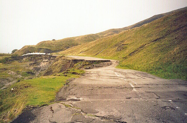
English: A section of the A6187 road, near Castleton, UK, destroyed by geological subsidence. Now permanently closed.
See en:Mam Tor, en:A625 road. See the plaque erected by the council for an explanation |
| Date | 15 February 2005 (original upload date) |
| Source | Transferred from en.wikipedia to Commons. |
| Author | AJB83 at English Wikipedia |
Licensing
| This work has been released into the public domain by its author, AJB83 at English Wikipedia. This applies worldwide. In some countries this may not be legally possible; if so: AJB83 grants anyone the right to use this work for any purpose, without any conditions, unless such conditions are required by law. |
[IMG]http://i876.photobucket.com/albums/ab324/muffinthemule/DSC02140.jpg[/IMG] the road today 24-8-11
Original upload log
The original description page was here. All following user names refer to en.wikipedia.
- 2005-02-15 22:09 AJB83 948×622×8 (134991 bytes) {{PD-user|AJB83}} A section of the A6187, near Castleton, UK, destroyed by geological subsidence. Now permanently closed.
File history
Click on a date/time to view the file as it appeared at that time.
| Date/Time | Thumbnail | Dimensions | User | Comment | |
|---|---|---|---|---|---|
| current | 10:27, 16 August 2007 | | 948 × 622 (132 KB) | wikimediacommons>Woudloper | {{Information |Description=A section of the en:A6187 road, near Castleton, UK, destroyed by geological subsidence. Now permanently closed. See en:Mam Tor, en:A625 road. See the [http://www.pberry.plus.com/ukroads/road_trips/mam_tor/plaque |
File usage
The following 18 pages use this file:
- Cs:Key:abandoned:*
- Key:abandoned
- Key:abandoned:*
- Key:abandoned:highway
- Pl:Key:abandoned:*
- Tag:abandoned=yes
- Uk:Key:abandoned:*
- DE:Key:abandoned:*
- DE:Key:abandoned:highway
- DE:Tag:abandoned=yes
- FR:Key:abandoned
- FR:Key:abandoned:*
- FR:Tag:abandoned=yes
- ES:Key:abandoned:*
- IT:Key:abandoned
- RU:Key:abandoned
- RU:Key:abandoned:*
- JA:Key:abandoned:*