File:T garmin.jpg
Jump to navigation
Jump to search


Size of this preview: 800 × 532 pixels. Other resolutions: 320 × 213 pixels | 640 × 425 pixels | 960 × 638 pixels.
Original file (960 × 638 pixels, file size: 72 KB, MIME type: image/jpeg)
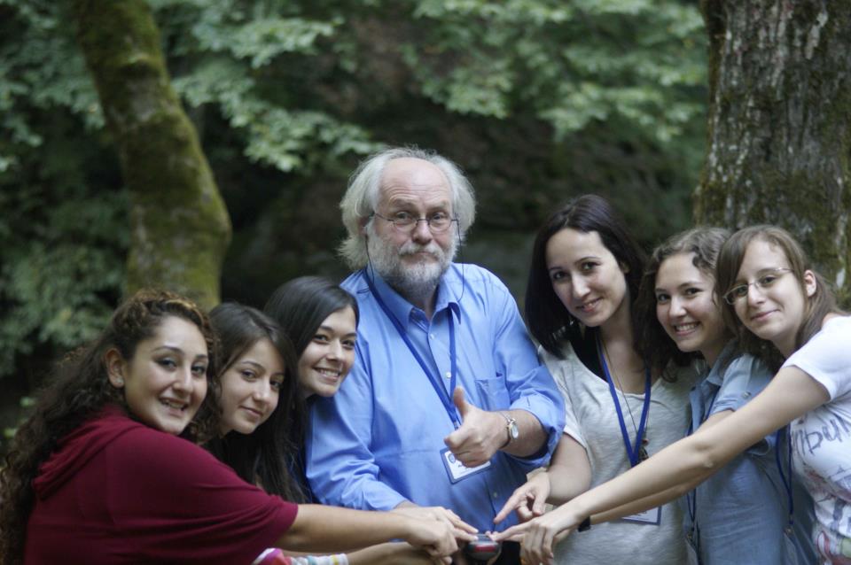
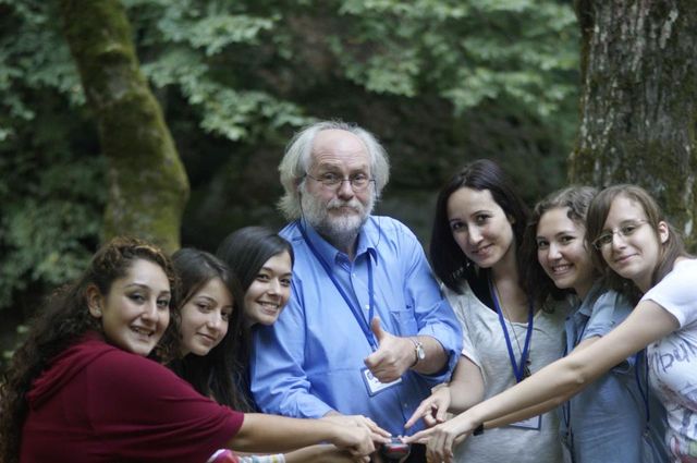
from left to right: students: Şeyma, Kader, Neslihan,(teachers: Manfred, Miray) Simge, Özge.
Our project aims to tackle the issue of gender-stereotyping. Students from Karacabey, Turkey, learning how to use a tracking device (Garmin) to improve OSM in Turkey.
Tr:Life Long Learning Mapping Project
As per discussion...
![]()
![]()
![]()
This work is licensed under the Creative Commons Attribution-ShareAlike 2.0 License.
Attribution not specified as a parameter! THIS LICENSE ALWAYS REQUIRES ATTRIBUTION! Use {{CC-BY-SA-2.0|Attribution, typically name of author}} See Template:CC-BY-SA-2.0 for full description how this template should be used.
Note, there is
There is also
Attribution not specified as a parameter! THIS LICENSE ALWAYS REQUIRES ATTRIBUTION! Use {{CC-BY-SA-2.0|Attribution, typically name of author}} See Template:CC-BY-SA-2.0 for full description how this template should be used.
Note, there is
{{CC-BY-SA-2.0 OpenStreetMap}} for files based on old OSM map data, before the license change made on 2012-09-12.There is also
{{OSM Carto screenshot||old_license}} for files based on old OSM map data, before the license change made on 2012-09-12, created using OSM Carto map style.
This is a Featured image, which means that it has been identified as one of the best examples of OpenStreetMap mapping, or that it provides a useful illustration of the OpenStreetMap project. If you know another image of similar quality, you can nominate it on Featured image proposals.
Front-page image for week 7 of 2013 (11–17 Feb.).
- Image descriptions
- Deutsch : Die türkischen Studentinnen Şeyma, Kader, Neslihan, (die Lehrer Manfred und Miray), Simge und Özge lernen im Life Long Learning Mapping Project wie man mit einem GPS-Gerät (Garmin) umgeht. Dabei verbessern sie die OSM Daten rund um die Stadt Karacabey in der Türkei.
- English : Life Long Learning Mapping Project : Şeyma, Kader, Neslihan,(teachers: Manfred, Miray) Simge, Özge, Our project aims to tackle the issue of gender-stereotyping. Students from Karacabey, Turkey, learning how to use a tracking device (Garmin) to improve OSM in Turkey.
- français : Life Long Learning Mapping Project : Şeyma, Kader, Neslihan, (enseignants : Manfred, Miray), Simge, Özge. Notre projet a pour but de donner un coup de pied dans les stéréotypes des genres. Des éudiants de Karacabey en Turquie, apprennent à utiliser un périphérique de géolocalistion (Garmin) afin d'améliorer OSM en Turquie.
- italiano : Life Long Learning Mapping Project : Şeyma, Kader, Neslihan,(insegnanti: Manfred, Miray) Simge, Özge. Il nostro progetto si propone di affrontare il problema degli stereotipi di genere. Studentesse di Karacabey, Turchia, imparano ad usare un dispositivo di tracciamento (Garmin) per migliorare OSM in Turchia.
- slovenščina : Turški dekleta se učijo, kako razporediti z Garminom v Karacabey, Bursa
- Türkçe : Life Long Learning Mapping Project : Şeyma, Kader, Neslihan,(teachers: Manfred, Miray) Simge, Özge.4 farklı ülkeyle (Almanya,Portekiz,Slovenya,Romanya) yürüttüğümüz haritalama projesinde Bursa,Karacabey de misafir ettiğimiz ortaklarımızla Mustafakemalpaşa'nın Suuçtu Şelalesinde Garmin kullanarak izleme yapan öğrenci ve öğretmenlerimiz..
- 中文(简体) : Life Long Learning Mapping Project:eyma、Kader、Neslihan,(老师:Manfred,Miray) Simge、Özge;我们的计画目标着重在打破性别刻板印象的窠臼。从土耳其卡拉贾贝伊来的学生,学习怎么用轨迹记录装置 (Garmin) 增进土耳其的开放街图状况。
- 中文(繁體) : Life Long Learning Mapping Project:eyma、Kader、Neslihan,(老師:Manfred,Miray) Simge、Özge;我們的計畫目標著重在打破性別刻板印象的窠臼。從土耳其卡拉賈貝伊來的學生,學習怎麼用軌跡記錄裝置 (Garmin) 增進土耳其的開放街圖狀況。
File history
Click on a date/time to view the file as it appeared at that time.
| Date/Time | Thumbnail | Dimensions | User | Comment | |
|---|---|---|---|---|---|
| current | 18:16, 1 February 2013 | | 960 × 638 (72 KB) | Fredao (talk | contribs) |
You cannot overwrite this file.
File usage
The following 9 pages use this file:
- Featured images/Jan-Mar 2013
- Life Long Learning Mapping Project
- List of featured images/2013
- Tr:Life Long Learning Mapping Project
- Template:Iotw image/2013-7
- DE:Featured images/Jan-Mar 2013
- FR:Featured images/Jan-Mar 2013
- ES:Proyecto de mapeo Aprendizaje a Largo Plazo
- IT:Featured images/Jan-Mar 2013