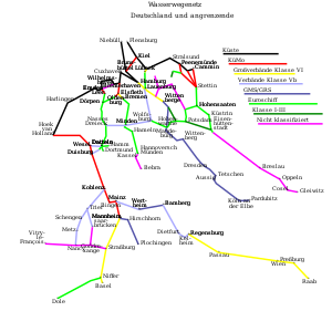
Key:CEMT
 |
| Description |
|---|
| Classification of European Inland Waterways |
| Group: restrictions |
| Used on these elements |
| Requires |
|
| Useful combination |
|
| Status: de facto |
| Tools for this tag |
|
CEMT is a classification for European inland waterways and extends waterway=* (axis of river, canal, fairway). CEMT=* is used on the European waterways that make up its water-based transportation network.
CEMT=* should only be used in correspondence with the official CEMT classification of the waterway. For waterways that lack a CEMT classification, see the other water-based transportation tags in the access tree.
Waterways
 |
 |
List of all European inland waterways: WikiProject_Europe/E-waterway_network
Classification
| Seamark / iENC ... : category |
CEMT-Class/Value | max. Length | max. Width | max. Draught | Height | Remark |
|---|---|---|---|---|---|---|
| 1 | 0 | - | - | - | - | inofficial, used for recreational boating fairways |
| 2 | I | 38,50 | 5,05 | 1,8-2,2 | 4 | of regional importance |
| 3 | II | 50-55 | 6,6 | 2,5 | 4-5 | of regional importance |
| 4 | III | 67-80 | 8,2 | 2,5 | 4-5 | of regional importance |
| 5 | IV | 80-85 | 9,5 | 2,5 | 5,25-7 | of international importance |
| 6 | Va | 95-110 | 11,4 | 2,5-4,5 | 5,25-7 | of international importance |
| 7 | Vb | 172-185 | 11,4 | 2,5-4,5 | 5,25-9,1 | of international importance |
| 8 | VIa | 95-110 | 22,8 | 2,5-4,5 | 7-9,1 | of international importance |
| 9 | VIb | 185-195 | 22,8 | 2,5-4,5 | 7-9,1 | of international importance |
| 10 | VIc | 193-200 | 34,2 | 2,5-4,5 | 9,1 | of international importance |
| 11 | VII | 195/285 | 34,2 | 2,5-4,5 | 9,1 | of international importance |
The unofficial classificiation CEMT=0 is often used when source data (such as government provided data on waterways) marks this as a waterway suitable for general recreational use. CEMT=0 implies motorboat=yes and canoe=yes, but also tends to strongly imply ship=no.
The presence of CEMT=* with value of I or higher, implies that an inland waterway is ![]() navigable (within the size and draught constraints shown in the table above) for the purposes of water transport.
navigable (within the size and draught constraints shown in the table above) for the purposes of water transport.
- Navigable waterways are rendered in dark green on the openriverboatmap map.
- Waterway Router: European Navigable Waterways
CEMT=* is not the only tag that can indicate navigability on waterways. Outside of Europe, ship=* may be used instead for shipping links. For waterways that lack a CEMT=* tag, boat=* and its descendants can be used to indicate navigability by smaller vessels.
Tools
- JOSM style european-waterways-classification-style
- CEMT Wikipedia article (in English)
Sources
- map-viewer (also ARCgis REST), pdf-maps, database UNECE.org
- map-viewer (also wms and wfs) vaarweginformatie.nl
- map-viewer (also wms and wfs), pdf-maps wsv.bund.de
- lists Landeswasserstraßen (CEMT=0)
- vnf.fr
- map-viewer visuris.be
- pdf-maps viadonau.org
- gov.pl
- pdf-text and maps gov.pl
- pdf-map mgm.gov.pl (high-resolution)
worth digging deeper
- https://vayla.fi/web/en/waterways
- https://kartta.paikkatietoikkuna.fi/?lang=en > Transport_Network
- http://voies-hydrauliques.wallonie.be/opencms/opencms/fr/vn/carte/cartet.html
- https://geoportal.cuzk.cz/geoprohlizec/
- https://mapy.geoportal.gov.pl/imap/Imgp_2.html?
See also
- Inland navigation
ship=*boat=*motorboat=*route=waterway- A signed navigable waterway (for motorboats and ships)route=motorboat- A recreational route specifically signed for motorboats (and not signed for other boats such as canoes)route=canoe- A signed route for canoes, kayaks, or other paddle craft.- Whitewater sports
- JOSM-style-snippet
- Seamarks/Categories_of_Objects#CEMT_Classes_.28catccl.29 might be used on waterway-axis or waterway-area
NSIW=*
References
- European Conference of Ministers of Transport (12 June 1992). Resolution No. 92/2 on New Classification of Inland Waterways.