Rationale
Provide a classification scheme for mapping the difficulty of trails suitable for motorcycling.
This is an adaption of several Proposals brought in concerning Mountainbike
Applies to
How to Map it - Usage, Tags and Values
The main key to be used is motorcycle:scale=1 to 5.
This shall be used for classifying the level of difficulty of using a trail or road.
Based on the German Denzel-Alpenstraßen-Skala [[1]]
motorcycle:scale applies primarily to ways. The difficulty should be based on the general difficulty over a longer stretch of a way, there can be a few places where the difficulty is higher. Those places should be classified on a point of the way.
Crux spots or very difficult single places
In order to highlight spots on a way, that feature a difficulty that is clearly more difficult than the way in general (e.g. one full grade more difficulty), on can highlight them by placing a node on the way with the difficulty to clear that node (do not highlight every switchback of a way however). If you put a point with motorcycle:scale=1-5 (0 makes no sense) outside of the way, then this shows a place that is more difficult, but can be circumvented.
motorcycle:scale=1-5
The main tagging scale.
| Tag
|
Description
|
Example Picture
|
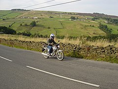
| motorcycle:scale=1
|
Very easy to drive mountain route, also for beginners.
- normal roadway width of at least 6 m, good asphalt or concrete
- continuous edge protection
- no tight bends, at most a few, wide bends
- Gradients up to max. 9%
- suitable for all motorcycle types
|

|
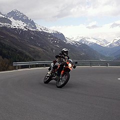
| motorcycle:scale=2
|
Track without significant requirements, even easy to drive for people not used to alpine roads.
- Two-lane carriageway, mostly paved
- Margin protection largely available, traffic-correct route
- Sufficiently wide turns with barely noticeable incline in the inserts
- Gradients up to max. 15%
- Suitable for all motorcycle types
|

|
| motorcycle:scale=3
|
Route requires practice and safe driving technique on mountain roads.
- Mostly just two lanes, partly single lane with dodging
- Partially or completely missing asphalt surface, bad condition
- Margin security is missing to a large extent
- Many, strongly curved curves, tight turns with a stronger slope
- Over longer distances more than 15% slope
- Only partially usable for sports motorcycles
- Mostly unsuitable for racing bikes, possibly with wider tires possible, adjusted to high inclines
|

|
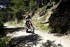
| motorcycle:scale=4
|
Even for mountainous difficult route, requires far above average outstanding driving skills.
- Mostly single lane, few passages
- Barely maintained roadway; i.e. coarse gravel, heavily washed out or extended, side slopes possible, is slippery in the wet (mud, grass), possibly bottlenecks, passable fords
- Except for a few dangerous places no edge protection
- Very tight curves
- Strong gradients, partly at altitudes with thin air (over 2000 m)
- Recommended for off-road vehicles, coarse tire tread
- For Enduros, partly for touring bikes with sufficient ground clearance, coarse tire profile recommended
- Climbs
|

|
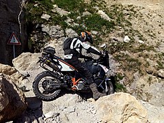
| motorcycle:scale=5
|
Very difficult and dangerous route, use at your own risk
- Hardly existing lane, near to offroad
- Barely recognizable route conservation, coarse gravel, bare rock, sand, mud; dangerous bottlenecks, high risk of falling rocks, strong erosion and side slope, at times (depending on weather, season) impassable fords
- Completely unsecured margins, also on both sides exposed crest, heavily exposed
- Not always recognizable routing
- Extreme slopes, even at altitudes over 2000 m
- Only for offroad professionals with appropriate vehicles
- Only Enduros and Motocross bikes, possibly also dual sport bikes, a lot of ground clearance and suitable tires
|

|
Examples
Sort by "SG" (Schwierigkeits Grad = Difficulty level)
https://alpenrouten.de/alpenpaesse.html
See Also


