Proposal:Highway=street
| Tag:highway=street | |
|---|---|
| Proposal status: | Draft (under way) |
| Proposed by: | Mvexel |
| Tagging: | highway=street
|
| Applies to: | |
| Definition: | Public access road, lowest importance. |
| Statistics: |
|
| Rendered as: | 
|
| Draft started: | 2021-07-03 |

Public access roads of lowest importance that can be driven with a regular passenger vehicle.
Replacing highway=unclassified and highway=residential, highway=street is used for any public access road that does not fall into any of the higher importance road types highway=motorway, highway=trunk, highway=primary, highway=secondary, highway=tertiary.

Rationale
- Reduce unnecessary complexity. There aren't enough differences between
highway=unclassifiedandhighway=residentialthat could not reasonably be coded with tags on ahighway=streetinstead of having separate highway values. - Avoiding confusion. The value 'unclassified' in itself is confusing because it doesn't mean what a mapper intuitively think it would: it is not meant to be a road without classification. Furthermore, unclassified and residential are rendered the same way on osm.org, suggesting they are very similar. This leads to inconsistent mapping practices where both are used interchangeable in some places.

Tagging
Physical appearance
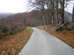
There is no universally applicable physical description of highway=street. The example image shows a typical highway=street in a European context. See the existing examples for highway=residential and highway=unclassified.
Place in the road network hierarchy
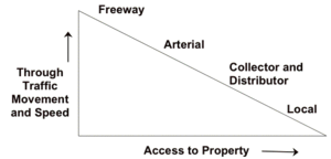
In a typical road network hierarchy, highway=street corresponds to a Local road. characterized by lowest speed limits, and carrying low volumes of traffic.
Additional tags
This section is to be expanded with guidance for additional tags to use to distinguish between residential streets and other streets for mappers who care about maintaining that distinction.
Migration
Transition from residential and unclassified
Mappers are welcome to keep using highway=residential and highway=unclassified. However, over time, these tags will lose their distinctive meaning as services that use OSM data will no longer distinguish between them.
Currently, no bulk modification to migrate all highway=residential and highway=unclassified is planned. This should be considered at some appropriate future time to avoid confusion among mappers and data users.
Guidance for data users
Users of OSM data are advised to use the same rules for highway=residential, highway=unclassified and highway=street, and discourage the use of highway=residential and highway=unclassified in their application and documentation wherever applicable. They should not
Editing software
Editors such as iD and JOSM should no longer offer presets for highway=residential or highway=unclassified, and replace these presets with one preset for highway=street.
Over time, validation rules could be implemented that point mappers to use of deprecated usage of highway=residential and highway=unclassified.
Rendering software
highway=street should be rendered to clearly indicate that it is a public access roads of lowest importance that can be driven with a regular passenger vehicle.
The standard OSM map style should adopt the existing rendering for highway=residential.
Other naming options
In the early stage of this proposal, we can still consider other naming options. highway=street has the advantage that it is not in use yet. Previously, highway=minor has been proposed for a different purpose. highway=road could also be an option, but that tag is currently used for roads without a known classification, because they have not been surveyed. highway=minor_road may also be an option.
The discussion tab of this proposal has a topic on naming as well.
Statistics
External discussions
Comments
Please comment on the discussion page.