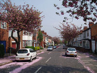
Tag:highway=residential
 |
| Description |
|---|
| Road in a residential area |
| Rendering in OSM Carto |

|
| Group: highways |
| Used on these elements |
| Implies |
| Useful combination |
| See also |
| Status: de facto |
| Tools for this tag |
The highway=residential tag is used on roads within residential areas, or providing access to them. While these roads typically allow through traffic, they are not normally used as through routes. Most traffic on a residential road will be for the access to residential properties. Roads carrying primarily through traffic, or non-residential traffic, should be tagged with a different highway tag (e.g. unclassified, tertiary) as appropriate (see highways). Roads to individual dwellings would normally be tagged as highway=service (and likely service=driveway).
For tagging in towns and cities, it can be useful to consider the following:
residential– street or road generally used for local traffic within the settlement. Primarily used for access to residential properties but may include access to some non-residential properties (e.g. a corner shop or convenience store). Likely to have lower speed limits or traffic calming measures in place.unclassified– roads with the lowest priority in the interconnecting road network. Use when the traffic is not just for residential access, even if residential properties may also be accessed by this road.tertiary– usage is dependent upon local mapping conventions, but is often used on a linking or connecting road with low to moderate traffic. May still be in a residential area, and may have residential properties abutting it, but will normally connect up multiple residential roads, local centers of activity, or other suburbs.
See also:
living_street– a street where pedestrians have priority over cars, children can play on the street, maximum speed is low.service– a service road for access to a building, service station, beach, campsite, industrial estate, business park, etc.
How to map
Draw a way and add the highway=residential.
Tags to use in combination
name=*– Street nameold_name=*– Former street nameoneway=yes– One-way streetpostal_code=*– Postal codemaxspeed=*– Maximum speedsurface=*– Road surfacesmoothness=*– The condition of the road surfacelane_markings=*– If there are visible lane markingslanes=*– Number of laneswidth=*– Road widthsidewalk=*– Sidewalkcycleway=*– Bicycle pathlit=yes– Illuminatedparking:left=*+parking:right=*orparking:both=*access=*– Rules of use, e.g. residents freeabutters=*– Type of settlement, e.g. commercial areaname:etymology:wikidata=*– Wikidata object for the nametunnel=building_passage– House passagebridge=*– Bridgewinter_service=*– Winter maintenance

surface=* are worth tagging, even if obvious to local residents. In some parts of the world it is expected that road will be paved, in some not. And name, oneway, etc. are even more useful.United States – TIGER data import
- Further information: TIGER fixup#Wrong highway classifications
The large scale TIGER data input of United States street data overused this tag. A significant proportion of these roads could be tagged as unclassified or tertiary under the guideline mentioned above.
| ||||||||||||||||||||||||||||||