Tag:highway=trunk_link
 |
| Description |
|---|
| The link road (sliproad / ramp) leading to and from a trunk highway. |
| Rendering in OSM Carto |

|
| Group: highways |
| Used on these elements |
| Useful combination |
| See also |
| Status: de facto |
| Tools for this tag |
Use highway=trunk_link for link roads (sliproads and ramps) leading to and from a trunk highway.
Also used for "channelised" (physically separated by an obstruction) at-grade turning lanes connecting the through carriageways/through lanes of a trunk highway to other minor roadways.
Slip roads/ramps are usually considered to "belong" to the through highway they exit and enter. This is usually the higher classification of the intersecting highways because on and off ramps almost always have the same kind of restrictions as the main road. Therefore, trunk_link should be used on a slip road/ramp which connects a trunk to a primary, secondary, or minor highway.
See link (highway) for details and exceptions.
How to map
To map a simple primary link highway you can just draw a line for it. Select the way and tag with highway=trunk_link. Use oneway=yes when it is not possible to drive in both directions on the highway. Make sure the way points in the same direction as the one way goes, otherwise reverse the direction or use oneway=-1.
To attach more information for the highway you should add further keys:
destination=*- Link roads normally do not have names. Please usedestination=*and its extensions tag to give the cross-street's ref=* and signed destinations such as a city or the name of the destination street, so that routing engines can correctly announce the exit to the "name or ref of the destination street" as you enter the _linkmaxspeed=numberThe maximum speed, in kilometres per hour which is allowed on the road, for example 120maxweight=numberThe weight limit in tonnes, for example 5.5lanes=*The number of lanesmotorroad=*indicates if this road has the Motorcars Only traffic rule
Example
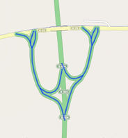
In the example, the trunk highway is green and the trunk_link connecting ramps are marked in blue. There are sections that are mapped with oneway=yes and others that do not receive this property.
Exit point
The point ![]() of the exit is mapped with the following:
of the exit is mapped with the following:
See also
| ||||||||||||||||||||||||||||||
