Rapid
| Rapid | ||||||||||||||||||||||||||||||||||||||||||||||||||||||||||||||||||||||||||||||
|---|---|---|---|---|---|---|---|---|---|---|---|---|---|---|---|---|---|---|---|---|---|---|---|---|---|---|---|---|---|---|---|---|---|---|---|---|---|---|---|---|---|---|---|---|---|---|---|---|---|---|---|---|---|---|---|---|---|---|---|---|---|---|---|---|---|---|---|---|---|---|---|---|---|---|---|---|---|---|
| Authors: | iD developers, Meta Platforms, Inc. | |||||||||||||||||||||||||||||||||||||||||||||||||||||||||||||||||||||||||||||
| License: | ISC License | |||||||||||||||||||||||||||||||||||||||||||||||||||||||||||||||||||||||||||||
| Platform: | Web | |||||||||||||||||||||||||||||||||||||||||||||||||||||||||||||||||||||||||||||
| Status: | Active | |||||||||||||||||||||||||||||||||||||||||||||||||||||||||||||||||||||||||||||
| Version: | 2.5.2 releases (2025-01-17) | |||||||||||||||||||||||||||||||||||||||||||||||||||||||||||||||||||||||||||||
| Language: | multiple languages
| |||||||||||||||||||||||||||||||||||||||||||||||||||||||||||||||||||||||||||||
| Website: | https://rapideditor.org | |||||||||||||||||||||||||||||||||||||||||||||||||||||||||||||||||||||||||||||
| Source code: | facebook/Rapid GitHub | |||||||||||||||||||||||||||||||||||||||||||||||||||||||||||||||||||||||||||||
| Programming language: | JavaScript | |||||||||||||||||||||||||||||||||||||||||||||||||||||||||||||||||||||||||||||
|
Fast PixiJS based renderer developed and maintained by a professional team featuring AI-generated data and authoritative open map dataset catalog for users to validate. | ||||||||||||||||||||||||||||||||||||||||||||||||||||||||||||||||||||||||||||||
| ||||||||||||||||||||||||||||||||||||||||||||||||||||||||||||||||||||||||||||||
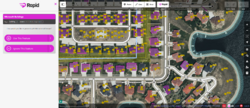
Rapid (formerly RapiD) is an extended version of the iD editor, maintained by Meta. Meta provides AI generated data: layers with roads, buildings, sidewalks, address points and trees. Also, this fork runs additional data validation checks during editing.
History
Rapid was forked from iD in 2019 [1][2]. On January 28th 2025 Bryan Housel, the main developer of Rapid[3], announced that he was being laid off by Meta[4][5]. As of May 2025, development appears to be stopped since March 2025[6].
How to edit with Rapid
Rapid suggests features, allowing the mapper to decide which is to be added to the map. Suggested features highlighted with a magenta color. A mapper can select a suggested feature, then click “Use This Feature” to add it to the map. From there, it is like any other newly-digitized feature: the geometry and tags can be modified and then uploaded to OSM. Only features that are accepted by a mapper are uploaded to OSM.
Users can click the "Rapid Assist" button to see a catalog of open data, and search for various categories. These open data features can be accepted or rejected similar to the machine learning suggestions.
For more Rapid editing guidance and tips, please refer to the Rapid Self Service Training Document.
JOSM Plugin
There is a JOSM plugin called "mapwithai GitHub", which includes data from Microsoft Building footprints and Facebook roads. This tool is not part of Rapid editor by name or codebase, but uses the same APIs to retrieve the machine learning generated datasets. This plugin also retrieves the open datasets that Rapid displays.
AI-Generated Roads
Rapid incorporates road features generated through an artificial intelligence (AI) process. This process was developed by Facebook (now called Meta) using a deep neural net model and Maxar satellite imagery to predict road features. The roads are now available for most regions of the world. This page maintains the up-to-date list of countries with AI-generated roads available. Users can submit a request for road features to be generated in a new region or have data refreshed.
AI-generated roads are supported in most countries. It checks the up-to-date OpenStreetMap data, conflates the newly generated roads against existing roads, and only generates missing roads.
More information on the legacy work from Facebook’s AI-Assisted Road Tracing can be found on the project wiki.
Buildings
Building footprints from the AI-generated Microsoft Building Footprint Data are supported in most countries
(see https://github.com/microsoft/GlobalMLBuildingFootprints#faq for a complete list).
Beware, these building footprints most likely will not terrace buildings properly. Please check the buildings before uploading them. Like all external sources, this dataset has quality that requires reviewing every single building before potential use: users should take care to ensure adjustments and corrections are made as needed before submitting a change set.
Building footprints and satellite base layers may not agree, and the user should refer to local knowledge about how to properly align one to the other.
Esri ArcGIS Open Data
The Esri integration of ArcGIS Open Data/ Community Maps with Rapid means that open datasets released by the governments of local areas can be added to the map using Rapid.
Users can rapidly use local authoritative information provided by governments to assist in the evaluating accuracy of the current OSM features, along with other assistive data such as reference imagery layers and other AI-generated datasets mentioned above. Then users can add, edit or supplement features with building outlines, house numbers, sidewalks, and other address information using Rapid.
Read more about the available ArcGIS datasets and Esri's process through its Community Maps program for selecting, evaluating and processing those datasets prior to making them available for assistive editing within Rapid.
See also
- Try it at rapideditor.org
- AI Data Documentation
- AI-Assisted Road Tracing
- better-osm-org tampermonkey userscript that adds an edit link for Rapid in osm.org
- OpenHistoricalMap/Contributing#Rapid
References
- ↑ Announcement from July 2019 on Meta tech blog
- ↑ Thread from July 2019 about expansion in Malaysia
- ↑ Rapid contributor statistics on GitHub
- ↑ Bryan Housel on BlueSky: "Meta is cutting their budget that includes the work I do on Rapid, so I’m looking for a new job."
- ↑ Bryan Housel on OSM World Discord: "My expectation is that I won't be working on Rapid anymore unless another company wants to fund the work."
- ↑ Rapid commits on GitHub

