Tag:barrier=embankment
Jump to navigation
Jump to search
| Description |
|---|
| Using this tag is discouraged, use man_made=embankment instead. |
| Group: restrictions |
| Used on these elements |
| Status: deprecated |
| Tools for this tag |
|
This feature has been labeled as deprecated. The recommended replacement is: man_made=embankment.
The reason is documented in Deprecated features. You are still free to continue to use or interpret this tag as you see fit since OpenStreetMap does not have “banned features”.
Under no circumstances should you (semi-)automatically change “deprecated” tags to something else in the database on a large scale without conforming to the automated edits code of conduct. Any such change will be reverted.
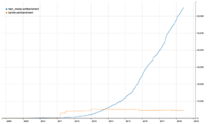
barrier=embankment is sometimes used to map a slope or steep incline. This tag was not documented prior to 4/2019. Most features with this tag were imported into the database in 2011, before man_made=embankment was an established tag.
A better documented and supported tags this feature is man_made=embankment. As of April 2019, barrier=embankment is used 4750 times, but man_made=embankment has been used over 80,000 times.
Related tags
- man_made=embankment - more commonly used
- embankment=* - used to indicate a raised road or other linear feature with embankments on both sides
- cutting=* - the opposite situation with slopes towards the feature in question
- natural=cliff - for vertical or near vertical drops of natural origin
- barrier=retaining_wall - for a artificial vertical or near vertical built wall with a function similar to man_made=embankment
- man_made=dyke - for an embankment (or levee) to redirect or prevent flooding by a river, lake or sea
- natural=earth_bank - earth bank is an abrupt change in ground level which can be clearly distinguished from its surroundings
- natural=gully - small scale cut in relief created by water erosion

