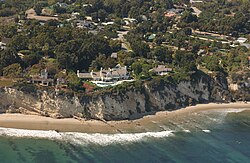
Tag:natural=cliff
 |
| Description |
|---|
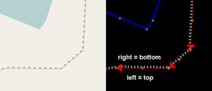
| A vertical or almost vertical natural drop in terrain, usually with a bare rock surface. The bottom of the cliff is on the right side of the way. |
| Rendering in OSM Carto |

|
| Group: natural |
| Used on these elements |
| Useful combination |
| See also |
| Status: approved |
| Tools for this tag |
A ![]() cliff is a vertical or almost vertical natural drop in terrain topography as it occurs for example in form of coastal cliffs or escarpments. The face of the cliff usually consists of bare solid rock but can occasionally also consist of clay, compacted sand, ice or other solid materials - for some materials other than rock
cliff is a vertical or almost vertical natural drop in terrain topography as it occurs for example in form of coastal cliffs or escarpments. The face of the cliff usually consists of bare solid rock but can occasionally also consist of clay, compacted sand, ice or other solid materials - for some materials other than rock natural=earth_bank could be a better choice.
How to map

To map a cliff draw a way along the edge of the cliff and tag it natural=cliff. The direction of the way should be so that the top of the cliff is on the left side of the way direction and the bottom on the right side. In the ID editor, the arrows on the line should be pointing out to the bottom of the cliff or low land. If the cliff is not perfectly vertical the way should be located on the top edge. Circular cliffs like craters or escarpment outliers can be drawn as closed ways.
You can use name=* tags to name the cliff and height=* for the maximum vertical distance between top and bottom. If there is rock debris at the bottom, use natural=scree to map this.
Nodes tagged natural=cliff can be used to map rock spires.
Artificial cliffs
For artificial cliff like features man_made=embankment and barrier=retaining_wall exist as more appropriate tags.
Ice cliffs
Cliffs usually have a bare rock surface so surface=rock or surface=bare_rock is implied by default. For mapping ice cliffs like at the calving edge of tidewater glaciers you can use surface=ice.
When not to use
natural=cliff should not be used for ridges, i.e. crests where there is a significant drop in terrain to both sides and neither of them is close to vertical. Use natural=ridge or natural=arete instead. Also do not use natural=cliff just for mapping an inclined bare rock surface, use natural=bare_rock instead.
Rendering
Renderers and editors might indicate the lower side of the cliff (the right side of the OSM way) with small triangles pointing downwards.
Related natural features
natural=earth_bank- similar feature for landforms created by erosion of earthnatural=bare_rock- areas of visible solid bedrocknatural=rock- isolated, notable rock features connected to the bedrock, mainly single node elementnatural=stone- large boulders and rocks (glacial erratics or rock fall) not attached to the bedrock, mainly single node elementnatural=scree- loose angular rock fragmentsnatural=glacier- glaciersnatural=areteandnatural=ridge- for a mountain stretch with descents to both sides
See also
- natural=cliff/Archive/Proposal
- Landform examples
- Waterfalls
- Proposed features/Mountains
- Proposed features/cliff clarification
man_made=embankmentbarrier=retaining_wall- Using the USGS 3DEP Digital Elevation Model (shows cliff lines more clearly than satellite photos)
