Tag:natural=bare_rock
Jump to navigation
Jump to search
 |
| Description |
|---|
| An area with sparse or no vegetation, so that the bedrock becomes visible |
| Rendering in OSM Carto |

|
| Group: natural |
| Used on these elements |
| See also |
| Status: approved |
| Tools for this tag |
|
An area of bare rock is sparsely vegetated or not vegetated at all, so that the solid bedrock becomes visible. Areas to tag could be:
- high altitude mountain areas where the rock lays bare, like summits, arêtes and rock faces, but not scree, shingle or moraines.
- rocky coasts
- rocky areas in uplands, desert and polar regions
- outcrops like open pit mines or road cuts
- monolithic mountains like Uluru (Ayers Rock).
How to map
To map an area of bare rock you can just draw a line closing on itself, marking the area as bare rock. To map larger or more complex areas you can use relation:multipolygon with the same tag.
It can be mapped as a node (if there is no way to map it as a geometry), especially when someone wants to map name or some other additional properties. But mapping as an area is strictly preferable.
Examples
-
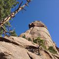 Precambrium Granite exposed at "The Castle" near Wellington Lake, Colorado, USA.
 -
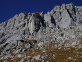 Triassic Limestone (Wettersteinkalk) in the "Wilder Kaiser", Northern Calcareous Alps (Austria, Scheffau)
 -
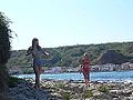 Stony coast at Susak Island, Croatia


Rendering
| osm-carto z13 | osm-carto z12 |
 |
 |
See also
natural=cliff- steep natural drop in terrain topographynatural=blockfield- pile of rocks, often formed as a result of volcanic or glacial activity.natural=scree- loose angular rock fragments formed by rockfall and weathering from adjacent rock facesnatural=shingle- rounded rock fragments on a beach or riverbed, deposited and shaped by movement of waternatural=stone- large boulders (glacial erratics or rock fall) not attached to the bedrock, mainly single node elementnatural=rock- isolated, notable rock features connected to the bedrock, mainly single node elementnatural=glacier- glacier areasgeological=*- geological features
Possible tagging mistakes
| ||||||||||||||||||||||||||||||||