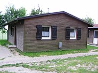
Tag:building=bungalow
| Description |
|---|
| Simple single-storey flat house. |
| Rendering in OSM Carto |

|
| Group: buildings |
| Used on these elements |
| Status: de facto |
Error loading from Taginfo API.
|
| Tools for this tag |
|
A ![]() bungalow is a small, single-storey detached house. Depending on the local conventions, it may have a lightweight construction with a flat roof and a veranda. Often these are used as small cottages, summer houses, large allotment houses or dachas.
bungalow is a small, single-storey detached house. Depending on the local conventions, it may have a lightweight construction with a flat roof and a veranda. Often these are used as small cottages, summer houses, large allotment houses or dachas.
A bungalow may be intended to be used as a tourist accommodation (see also tourism=chalet).
The generic tagging for a single-storey detached house is building=detached + building:levels=1.
Country-specific
UK
A few mappers have used in UK building=house + house=bungalow, however this has only been used about 100 times as of December 2020. It is also unclear whether this refers to the building style of residential homes or to bungalows used for tourism or leisure.
Germany
In Germany the term "Bungalow" is used for larger, single storey, detached houses (typically from the 1960ies and in concrete or masonry). It is not unlikely that at least some of the currently 25.000 objects with this tag in Germany are used according to this German usage of the word.
France
The term "Bungalow" is often used in French to refer to detached accommodation in a camping, or on a private property, often installed during all seasons. The term "Chalet" is also used for theses same accommodations but has a boarder meaning since it's also used to refer wooden houses in mountains, that should use tourism=chalet.
Curiosities
The editor StreetComplete does not consider a bungalow a building that usually has a housenumber and thus does not ask about it.

