Tag:sport=chinlone
Jump to navigation
Jump to search
| Description |
|---|
| Chinlone (Myanmar national sport) |
| Group: sports |
| Used on these elements |
| Useful combination |
| Status: proposed |
| Tools for this tag |
|
This tag page is a stub. You can help OpenStreetMap by expanding it.
Similar pages for structural reference: Tag:railway=tram, Tag:waterway=dock.
Similar pages for structural reference: Tag:railway=tram, Tag:waterway=dock.
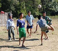
![]() Chinlone also known as caneball, is the traditional, national sport of Myanmar (Burma).
Chinlone also known as caneball, is the traditional, national sport of Myanmar (Burma).
How to map
Add this sport tag to any element representing a place where Chinlone can be played.
Since this is a non-physical tag it should be combined with other (physical) tags, eg leisure=pitch
Possible mistakes
The Chinlone field can easily be mistaken with a sport=volleyball field. In doubt, if you are in Myanmar or close, it should be Chinlone.
