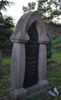
Tag:cemetery=grave
Jump to navigation
Jump to search
| Description |
|---|
| A place dug into the ground for the burial of a corpse, often marked with a gravestone. |
| Group: landuse |
| Used on these elements |
| Useful combination |
|
| See also |
| Status: de facto |
| Tools for this tag |
|
A grave is a place dug into the ground for the burial of a corpse, often marked with a gravestone. In areas where grave location/inscription is considered private information[1], please map only significant or notable graves.
How to map
Place a node ![]() in the middle of the grave or map the outline
in the middle of the grave or map the outline ![]() of the grave.
of the grave.
Tags used in combination
- name=* - adding the name of the deceased in the name=* tag is common practice
- inscription=* - text written on the grave or its headstone
- wikipedia=*, wikidata=* – Wikipedia article or Wikidata item about the grave itself (NOT the person buried inside)
- subject=* - name of the deceased person(s) buried here
- subject:wikidata=* or buried:wikidata=* – Wikidata item about the buried person(s) - both are in use. Note that there can be a case where grave of someone is former or symbolic and buried:wikidata=* does not apply.
- description=* - additional details about the grave itself
See also
- historic=tomb - for historical tombs, e.g., barrows, pyramids, rock tombs. While a grave is a place dug into the ground for the burial of a corpse, a tomb is a built structure.
- landuse=cemetery
- Limitations on mapping private information (graves were once listed as example as non-mappable, then clarified as allowed and removed from the list after discussion on talk page)
- Talk page - there are some objections that the practice of using name=* to map the name of the buried person violates the rule Name is the name only and that this tag should be used only for the name of the grave itself (NOT the person buried here). The matter is still unresolved.
- Proposal:Relation:person (rewrite) - another method used to map who is buried in a grave is adding the grave as member to a type=person relation with role "tomb" (Proposal is currently abandoned)
Tags popular in Poland
These tags were originally created and used over the last few years in Poland.
Pl:Tag:cemetery=grave
Proposal:Relation:person (rewrite)
With:
Maps
- Open Burial Map: Displays graves and details about buried people based on buried=*, subject:wikidata=*, buried:wikidata=* and type=person relations. It's also possible to change source to combine this data with the data from Wikidata.
- OpenStreetMap grave finder (GitHub)
This English article is a translated version, but the content appears to be out of sync with the reference text in Polish. Please update this translation if possible.
Possible tagging mistakes
References
- ↑ Situation varies across world, see for example how GDPR regulation may or may not apply to information about dead people
