Tag:crop=strawberry

From OpenStreetMap Wiki
Jump to navigation Jump to search
Public-images-osm logo.svg crop = strawberry
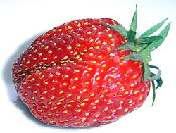
Strawberry gariguette DSC03063.JPG
Description
Specifies that an area of farmland is being used to grow strawberries. Show/edit corresponding data item.
Group: agriculture
Used on these elements
should not be used on nodesshould not be used on waysmay be used on areas (and multipolygon relations)should not be used on relations (except multipolygon relations)
Requires

landuse=farmland or landuse=orchard or such

Status: in use

Specifies that an area of farmland is being used to grow strawberries.

Please use singular "strawberry" value and not plural "strawberries"

This is the preferred way, do not use trees to map strawberry plantations.

information sign

This tag page is a stub. You can help OpenStreetMap by expanding it.
Similar pages for structural reference: Tag:railway=tram, Tag:waterway=dock.

Possible tagging mistake

If you know places with this tag, verify if it could be tagged with another tag.
Automated edits are strongly discouraged unless you really know what you are doing!