Tag:emergency=access_point
 |
| Description |
|---|
| A sign number which can be used to define your current position in case of an emergency |
| Group: emergencies |
| Used on these elements |
| Useful combination |
|
| See also |
| Status: in use |
| Tools for this tag |
This text describes an alternative tag to the older highway=emergency_access_point. You can compare the development of both tags on the OSM Tag History. |
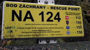
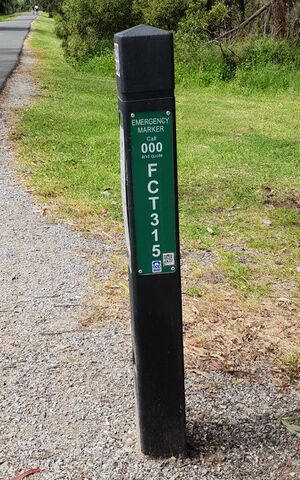
Emergency access points are signs with an ID which can be used to find and share your current position with authorities in case of an emergency.
Some countries, particularly in Europe, have networks of emergency access points (sometimes also called "rescue points" or "access point for emergency services"), in particular used in remote areas such as forests or larger water bodies. These points are at least signed with an identifier, and commonly additional information such as a name, phone number of emergency services or current elevation.
In case of an emergency, one can give emergency services the identifier of a given access point, which allows them to not only look up the location but also details such as potential landing points for helicopters, access routes by land, etc.
This tag is supposed to be the replacement for highway=emergency_access_point.
How to map
This tag is applied to nodes ![]() .
.
In addition to applying emergency=access_point, add ref=* with the reference number / ID shown on the sign.
Additional information given on the sign, such as emergency_telephone_code=* with the phone number, or operator=* for the operator, and name=* with the name of the sign can be given too.
Tagging considerations
Emergency access points in most places are limited to remote and less densely populated areas - e.g. in the outdoors and country-side, to provide location information in lieu of traditional address data.
An exception to this more regular use can be found in the Navarre province of Northern Spain, which has introduced the helpbidea emergency access point system. This system assigns each address an additional helpbidea sign and identifier. In OSM these are tagged as operator=helpbidea. In September 2023, all 180,000 of them were imported into OSM.[1][2]
Examples
| Photo | Remarks |
|---|---|
 |
Example of a sign, here in the USA.
In the United States, some local governments have deployed standardized location markers using USNG Emergency Location Markers (ELM’s). |
 |
Another example of a sign. Rescue point sign in Czechia with Czech and English text |
 |
Pole-attached sign from Australia. For details on Victoria Australia emergency markers see https://data.gov.au/data/dataset/esta-emergency-markers |
 |
"Lotsenpunkt" on the left bank of the Danube in Austria. |
Tagging mistakes
This tag is not to be confused with the emergency=assembly_point tag, which describes a designated (safe) place where people can gather or must report to during an emergency or a fire drill.
See also
highway=emergency_access_point- alternative tag with the same meaning- The German version of this page has detailed information about this tag. (You can view Google's automatic translation to English)