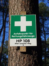
Tag:emergency=access_point
Jump to navigation
Jump to search
| Description |
|---|
| A sign number which can be used to define your current position in case of an emergency |
| Group: emergencies |
| Used on these elements |
| Useful combination |
|
| See also |
| Status: in use |
| Tools for this tag |
|
Sign with an ID which can be used to define your current position in case of an emergency.
Replacement for highway=emergency_access_point
Tag evolution
Beside of the organic growth from 0 (2010) to 10k (August 2023) units, there took place an import of 180k units for Spain area in September 2023. [1] [2]
See also
- highway=emergency_access_point - alternative tag with the same meaning
- The German version of this page has more detailed information about this tag. (Or you can view Google's automatic translation to English instead.)
- emergency=assembly_point - A designated (safe) place where people can gather or must report to during an emergency or a fire drill
