Latest comment: 6 years ago29 comments7 people in discussion
While this proposal is better than its predecessors, I still believe that soil won't naturally remain unvegetated for more than a few months, except in permafrost or if the soil is toxic. The example images are all from Somalia, and they look like something in between desert (natural=desert) and savanna (natural=grassland). For this proposal to get approved, you need some terrestrial (on-the-ground) photos to make clear what natural=bare_soil really looks like. --Fkv (talk) 10:03, 10 July 2020 (UTC)Reply
You are right. It was in Somalia, changed. As I wrote in the wiki, natural=desert would be a nice solution, but it doesn't seem to be an accepted feature. Also, I believe not all arid areas are deserts. natural=grassland could be used, but with imagery taken in rainy and dry seasons (as well in different years) we don't see grass or vegetation coming there at all. Therefore we think it would be misleading to map it as grassland. I agree with you terrestrial imagery would help. --Michael Montani
Lacks context but looks like a artificially prepared surface for a specific purpose - maybe amenity=parking or highway=service + area=yes + surface=unpaved. --Imagico (talk) 13:49, 10 July 2020 (UTC)Reply
Definitely some natural=bare_rock in the foreground. The trees and scrubs in the background indicate that the loose material partly covering the rocks might not actually be vegetation free. --Imagico (talk) 13:49, 10 July 2020 (UTC)Reply
Lacks context but most likely some landuse=construction. Definitely not a long term stable situation, if left as is would develop plant growth within a few months. --Imagico (talk) 13:49, 10 July 2020 (UTC)Reply
Construction sites do have bare soil actually --Michael Montani
Unpaved road in the foreground, background not detailed enough to characterize but there is definitely significant extents of natural=bare_rock and natural=scree but also likely till and alluvial sediments. --Imagico (talk) 14:02, 10 July 2020 (UTC)Reply
A couple more options, pulled from my survey photos:
[12]: A chewed-up hillside in an ORV park. If they were to close the park tomorrow, it would take at least a decade to see significant regrowth.
[13]: A section of Lone Star Geyser Basin. It's even less hospitable: the stray plants you see in the background represent at least a half-century of regrowth.
The first one, maybe, but note the background in the second one: people don't walk there, and it's just as bare as the foreground. Geyserite is a very unforgiving material for plant growth. --Carnildo (talk) 05:34, 14 July 2020 (UTC)Reply
Here are two photos from the Atacama desert in northern Chile, which receives almost no rainfal. The soil is not very well developed, but I think it doesn't qualify as "sand" or "gravel", so it's best described as mostly bare soil:
[14] - very sparse, low vegetation near the coast, where fog provides some moisture)
[13] and [15] are very good examples of what I think bare_soil could be (in my opinion those kind of areas have not current OSM tagging) --Michael Montani, 14 July 2020
[16-25] Shots taken in Patagonia (La Leona). No rocks, no stones, no pebbles... Clay soil, if I well remember (very , very hard) --Mbranco, 27 July 2020
This is a classic example of badlands - and technically that is rock (of mesozoic age probably), fairly soft, easily erodable rock but not soil, there are no young organic components in there. If this is to be tagged natural=bare_rock or with a more specific tag is of course a question for discussion. --Imagico (talk) 13:11, 27 July 2020 (UTC)Reply
Going to add some comments on the two ground photo examples added to the proposal:
Both of these are in areas with climate conditions where vegetation free bare soil does not exist in the long term without special circumstances or human activities preventing growth of vegetation.
The first example you can see well developed scrubland on the left and in the background which under natural conditions would also cover the right side of the view probably. The lack of vegetation on the right is probably due to human activities - most likely intensive use by farm animals (there are excrements visible on the ground), probably in the vicinity of a watering place. That would deserve to be tagged as such (landuse=animal_keeping would be an option though it does not really apply for areas where animals stay temporarily only - a new tag might be required here).
The second example seems to be a similar setting - with in addition signs of recent construction work and use by vehicles (tire tracks). It also looks like the unvegetated area in the foreground is subject to occasional flooding - if it qualifies as an intermittent water areas is hard to tell without knowing the local conditions.
In both cases the key questions for the mapper would be: Why is that area free of vegetation and how is it predominantly used (because as indicated the lack of vegetation indicates quite intensive human use). That should be the basis of primary tag choice, not the physical appearance. Existing tags we know from the European context are often not well suitable because of different culture and life/work-style but that would call for inventing new specific tags, not a single umbrella tag focusing on physical appearance only.
Ok now I understood your point. Well those areas are widely present in Africa, for many different purposes. Human presence is for sure one of them, indeed those groundy areas can be found near settlements (landuse=residential fits very good here), near grazing areas (landuse=meadow is good for those, as grass is growing again there) or around roads. Most of the roads in Africa, especially in countryside, are traced on the ground simply because people is passing by there continuously during time, with trucks, cars or scooters, de facto tracing the road on an arid groundy area. These areas are not due only because of human presence though, but also for extreme climate, and actually people are using those areas to pass by with means of transport, rather than creating them on purpose; usage of the soil of this kind prevents vegetation to grow there, but that's not the only reason. That's why a landuse=* tag wouldn't be fine for such feature, as there is no landuse (not all those areas are covered by means of transports all the times, but used occasionally).
Here are 2 photos of the first example from imagery (Bing and Maxar, not in dry season).
The shrubs on the left are growing near a lake and are not able to grow further as the terrain is too arid, and for most of the time in the year. Some animals like wild dromedaries and goats are retrieving water from the scrub, but that is not an area in which people are growing farm animals (even because of crocodiles). There are some farmlands there, but the groundy areas is clearly never cultivated. It is by the way used by people passing by. Furthermore groundy areas like this one are present also in inhabited place (like deserts).
For the second example, the area was near a wetland because I was conducting a study on wetland areas. By the way, the area I took picture of is not flooded during the year or subject to intermittent water.
Furthermore I would fear to tag as scrub an area like this one (too much ground, too few shrubs..)
Concerning Imagico's statement that "Existing tags we know from the European context are often not well suitable because of different culture and life/work-style": I don't think there's a fundamental difference between Europe and Africa. Intensive grazing reduces vegetation in Europe as well, and the second photo very much looks like a quarry in central Europe. There's only a quantitative difference: The vegetation in arid areas takes longer to recover, and the climax vegetation not natural=wood, but natural=scrub/heath/grassland (which are just transition stadiums in humid areas). --Fkv (talk) 13:47, 27 July 2020 (UTC)Reply
OSM tagging system is weighted to much in favor of US/European features, and that's also because communities in Africa are not using mailing lists too much... Anyway more than different culture, I would say different life/work-style due to economic and climate conditions. Again, those areas are not used for intensive grazing. The ones which are used are very evident from satelitte imagery as well and most of the times they create hedges around those, especially in Somalia. I agree on your last point, natural=bare_soil could be considered the very first step of this natural vegetation climax which, especially in arid areas takes longer to exit from this stadium. --Michael Montani (talk) 14:52, 27 July 2020 (UTC)Reply
"...that would call for inventing new specific tags, not a single umbrella tag focusing on physical appearance only."
Why not an "umbrella" tag? highway=road is an umbrella tag, used by a mapper if he is not able to specify the highway type; someone after will specify better.
I have not defined the term umbrella tag so your reaction is understandable. highway=road in the way i used the term is not an umbrella tag, it is not suggested to be used in replacement of existing road classifications. It is a provisonal tag to apply to roads where the mapper can not reliably classify the road further because of the limited local verifiability of road classifications. So any highway=road feature has a correct and well established road classification for it and the tag is only used to allow the mapper to tag it without being able to determine the correct classification.
You've not defined umbrella tag but you used it, and I interpreted it in the most obvious way.
Mine was not a reaction, but an intervention in a discussion, and it seems to me that "highway=road is used by a mapper if he is not able to specify the highway type; someone after will specify better" should be an understandable sentence (but English is not my native language, so sorry if I don't express myself better).
I think that doesn't matter if highways are 100% well defined but it's not true for arid lands, for me the similarity remains valid: in the future, when we'll have all the specific tags for dry lakes, badlands, etc, a mapper can still continue to use natural=bare_soil if he will not be able to identify the appropriate tag.
And if it's better to use "provisional" instead of "umbrella", it's ok for me: your sentence " It is a provisonal tag to apply to ... where the mapper can not reliably classify the ... further because of the limited local verifiability of ... classifications. So any ... feature has a correct and well established ... classification for it and the tag is only used to allow the mapper to tag it without being able to determine the correct classification." for me works well as much for "roads" as for "arid lands". --Mbranco (talk) 10:33, 31 July 2020 (UTC)Reply
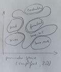
What you are doing here however is trying to create a new tag which is meant to apply to features for which there are either already existing tags (tags defined by specific uses that might or might not imply the presence of bare ground) as well as features for which no specific and well defined tagging exists yet but which could use one and which you instead engross with a lot of other very different features. Even if you'd redefine your tag not to overlap with existing established tags you would end up with an extremenly broad and at the same time complex definition - what i on the mailing list described as a residual tag. Mapping instructions would then be something like to be used for bare, unvegetated ground except for areas which qualify as a, b, c, d, e, f and g. Such a tag would end up being something like on the right Residual tag in parameter space which is practically neither accurately mappable nor of any use for data users.
Since perfection does not exist on this earth, I'm afraid that "residual tags" will always be necessary... "natural=scrub" is an example - in many circumstances - of residual tag : most mappers use it after they decide a certain area is not a wood/farmland/residential/etc.
About mapping accuracy, often it's not applicable with tags as natural=* and landuse=*: let's bring the ten best OSM mappers, and give them to map the residential landuse of a village (or the border between a wood and the adjacent scrub); don't you think we'll get ten different (in some case very different) mappings? --Mbranco (talk) 10:33, 31 July 2020 (UTC)Reply
I think this is the problem associated with landcover / landuse concept itself.
Classes don't have clear boundaries, so they are not crispy sets but fuzzy sets instead. Imagine the Imagico's plot with gray scale fuzzy boundaries around the sets.
Classes are not even clear within themselves, e.g. a wood with sparse tree could be mapped as landuse=forest, landuse=orchard, natural=wood, natural=scrub depending on the local knowledge of the mapper, her/his acumen, her/his mapping background and so on. That's why also algoritms have problems with landcover / landuse, it's a human-mind ill-posed problem...
By the way I understand Imagico's point that a landcover class should not designed as an a priori residual tag, but it's also true, as Mbranco is saying, that some landcover tags are already used as residual tags (natural=scrub and natural=sand are the best examples: for scrub the intent of mapping shrubs is clear, but it can range from sparse wood to little bushes here and there; for sand, it is correctly used to map sandy areas, but I saw it used to map groundy areas (completely different granulometry, compactness...), not to speak about deserts (which are characterised by a clear environmental meaning)).
I think Imagico's point is that tags like scrub and sand have a clear definition of what they are referring to, even if are then used as residual tags, while it seems bare_soil is not. I think the physical description of the feature we came up with (soil characteristics, sparse vegetation level and so on) is somewhat good, but it lacks of why we have to map bare_soil an area which, maybe, could be natural=wetland + intermittent=yes instead. If I should come up with a list of circumstances for why the bare_ground is there, and it's different from already existing tags (that in my opinion are not describing well bare_ground in any way) is:
Intensive use of farm animals in arid areas (and consequent no or very slow regrowth)
Big herds of wild animals (camels, cows...) grazing in those areas in rainy season
Extreme pollution of the soil which stops vegetation and life to grow there, but mantaining organic residuals.
Extreme climate (climate change causing desertification of areas which are not sandy, but have soil granulometry). This one would include desert pavements, as it seems sandy deserts will be mapped with natural=sand, someone in the future will maybe propose a + desert=yes... just check taginfo to see how natural=sand is clearly more used than natural=desert also in desert areas.
Human usage, of very different types, like navigation or loose urban planning
Dry lakes and playas if we are sure it will not come back to be humid. Otherwise it's a natural=wetland + intermittent=yes
So my recommendation again: Create new narrowly defined tags for the specific situations and conditions under which bare ground without vegetation exists for which currently there is no established tagging. Africa is a highly diverse continent where exposed bare ground exists under a huge variety of circumstances and for very diverse reasons. Mapping these circumstances and reasons would be the way to go. From the on-the-ground examples you showed i would definitely say a tag for areas that stay vegetation free because they are intensely used by farm animals (without being a paddock, pen or otherwise enclosed) - either as part of a meadow or dedicated grazing area or otherwise - would be of widespread use. Same exists for wild animals by the way - see [1][2]. We have also discussed other specific and pretty well defined cases like desert pavement, badlands, dry lakes/playas etc.
"... the key questions for the mapper would be: Why is that area free of vegetation and how is it predominantly used (because as indicated the lack of vegetation indicates quite intensive human use). That should be the basis of primary tag choice, not the physical appearance."
I'm not a geologist or a botanist, I'm able only to verify that in an area there is an arid, a desert terrain. One of the main OSM mapping rules is "map what you see", not "map why you're seeing that" :-)
About human use, in Africa there are a lot of arid lands very far from the nearest hamlet, in such cases human use can be excluded (see for example in Somalia, at 3.2904, 45.3790). --Mbranco (talk) 08:11, 28 July 2020 (UTC)Reply
Another place to look at, I would consider an area like this natural=bare_soil. There are farmlands, but this area is not cultivated, checking different images. There are shrubs but not too many to me to say it's scrub. Maybe some grass in rainy season will grow, but it will be only for 2-3 months per year, after that it will come back to be ground. Furthermore, people passing by will continously create new roads, denying growth of vegetation. I would map an area like this creating a polygon or a relation which is complementary to the sorrounding farmlands / scrub --Michael Montani (talk) 09:49, 28 July 2020 (UTC)Reply
Here is an example from Dublin, Ireland showing bare soil on a sizeable area (it's mapped as grass on OSM; I suspect because the construction site is no longer active / the imagery is old. Dónal (talk) 15:38, 28 July 2020 (UTC)Reply
Tagging
natural=bare_ground has been changed to natural=bare_soil as ground can include rocks, causing problems with existing natural=bare_rock --Michael Montani
Is mostly organic soil (e.g. humus) to be specified with further tagging? --Michael Montani
Overlap with specific types of soil
Latest comment: 6 years ago1 comment1 person in discussion
Currently we have more specific tags for certain types of mineral soil: natural=sand for mineral soil with is mostly sand particles (and not part of a beach) natural=scree and natural=shingle for areas of gravel and pebbles up to small boulders. Most areas of silt minera soil are going to be wetland=tidalflat or wetland=mud - though there is not an established tag for dry silt soil. And just afew times natural=clay has been used for mostly-clay soil, in a few places, but in general mappers have not yet been interested in mapping these areas more specifically - though. And there is also natural=bare_rock for areas of exposed bedrock or very large stones.
So is this new tag going to also be used for areas of silt or clay soil, or should it just be limited to areas of loam (mixed soil, with clay/silt/sand), or areas with mixed humus (organic matter) and mineral soil?
Should it not be used on areas of wetland or intermittent water?
What about areas of tundra where the soil is covered by a thin layer of lichen?
It would be good to attempt mapping some real-world places which you have visited personally, and illustrate with photos taken in person, as well as aerial imagery. --Jeisenbe (talk) 18:24, 10 July 2020 (UTC)Reply
According to TagInfo there are only 3 natural=clay in the whole OSM. So in my opinion natural=bare_soil should be used for silt or clay soil, loam and mixture humus and mineral soil. To me, all these areas don't have a current OSM tagging correctly defining all of them.
Right, it shouldn't be used with wetlands, which have an already good classification
Seems reasonable to me to map areas of tundra with natural=grassland.


![[1]](https://upload.wikimedia.org/wikipedia/en/0/00/SAC_Namibia-waterhole.jpg)
