Template:FR:Map Features:information
Jump to navigation
Jump to search
| Clé | Valeur | Élément | Comment | Rendu | Photo |
|---|---|---|---|---|---|
| information | office | Un office du tourisme qui fournit des informations sur une ville ou une région. |  | ||
| information | visitor_centre | Lieu où l'on peut obtenir des informations sur une attraction ou un lieu d'intérêt spécifique. |  | ||
| information | board | Un panneau informatif. Pour le décrire plus précisément, voir board_type=*.
|
 | ||
| information | stele | Une stèle d'information. |  | ||
| information | terminal | Un terminal d'informations électronique. Souvent connecté à l'internet. (voir internet_access=*)
|
 | ||
| information | audioguide | Une visite audio-guidée avec des écouteurs ou par téléphone portable. |  | ||
| information | map | Un panneau avec une carte. Pour indiquer le type ou la précision, voir map_type=*, map_size=*. Pour préciser quel sport/moyen de transport est concerné par la carte, utilisez hiking=yes, bicycle=yes ou ski=yes.
|
  | ||
| information | tactile_map | Les cartes tactiles sont des cartes pour les mal-voyants, aussi appelées cartes haptiques. Voir http://blind.accessiblemaps.org et HaptoRender |  | ||
| information | tactile_model | Les maquettes tactiles sont des modèles représentant un bâtiment et ses environs pour les mal-voyants. Voir http://blind.accessiblemaps.org et HaptoRender |  | ||
| information | guidepost | Un panneau indicateur est souvent placé le long d'une piste cyclable ou d'un sentier officiel pour montrer la direction de différentes destinations. Pour préciser l'accès aux chemins indiqués, utilisez les clés access comme hiking=yes, bicycle=yes ou ski=yes.
|
 | ||
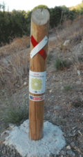
| information | post | Un petit poteau, érigé verticalement, avec des informations inscrites sur le dessus ou sur les côtés, ou sur une petite plaque. Un peu comme un poteau d'information, mais plus petit. |  | ||
| information | Un marqueur qui jalonne l'itinéraire et indique l'emplacement de la voie. Peut être un symbole, un petit poteau ou une marque peinte. À noter : il y a deux manières de cartographier actuellement en usage. |
   | |||
| information | user defined | All commonly used values according to Taginfo |
This table is a wiki template with a default description in English. Editable here. Version française éditable ici


