Zh-hans:Key:network
 |
| 说明 |
|---|
| 一种通常由单一机构或组织维护或指定的路线系统(或自行车租赁站),或者对于自行车和步行路线而言,是对路线范围的一种指示。 |
| 组: 属性 |
| 用于这些元素 |
| 另见 |
| 状态:实际使用 |
| 此标签的工具 |
网络功能在多种标记方案中用于各种各样的目的:
高速公路路线
在高速公路路线关系方面,这个表示公路系统。公路系统通常有统一的编号方案。一些常见值列于 路线类型 与 《类别:“network”键的标签说明》. network值的确切格式因国家而异。
Basic format
In many countries, the most common network values are XY:national and XY:regional, where XY is a two-letter ISO 3166-1 country code (最好用大写字母,以避免与各种标签中使用的语言代码混淆)。如果存在多个区域网络,它们可以遵循以下格式XY:regional:region.
Examples:
network=PL:nationalfor Polish national routesnetwork=UA:regionalfor regional routes anywhere in Ukrainenetwork=JP:prefectural:naganofor prefecture roads in Nagano, Japannetwork=IN:NHfor national highways in Indianetwork=IN:SH:UPfor state highways in Uttar Pradesh, India
Hierarchical format
在一些国家,公路路线的网络值遵循分级体系。冒号分隔各个组成部分,按重要性排序,这些部分可能包括国家、地区、区、网络名称以及 auxiliary network name (see also modifier=*). 在可用的情况下,请使用标准代码(例如 ISO 3166-1和 ISO 3166-2中的代码)而不是拼写出来的名称。这种方案非常适合那些在国家、地区或地方层面拥有多个网络的国家,以至于存在多条不相关的路线,例如都被称为“1号区域公路”之类的。
截至2016年11月,已知巴西、加拿大、中国、法国、意大利、斯洛文尼亚和美国都在使用这种分级格式。
Examples:
network=CA:QCfor provincial routes in Québec, Canadanetwork=FR:01:D-roadfor departmental roads in Ain, Francenetwork=US:TX:FMfor Texas' statewide Farm to Market networknetwork=US:TX:FM:Businessfor Texas Farm to Market business routesnetwork=US:NY:Dutchessfor county routes in Dutchess County, New Yorknetwork=US:OH:MED:Harrisvillefor township routes in Harrisville Township, Medina County, Ohio
Support
OpenStreetMap Americana uses the network=* key on route relations to display accurate route markers in over 50 countries and countless country subdivisions. It is hoped that the Standard tile layer will someday adopt network=*-based route shields as well.
公共交通
On route relations for bus, railway, and tram service routes, this key indicates the bus system, if applicable. There is currently no consensus whether the values should be abbreviated or not. It is an optional key for stops.
在美国,使用常用缩写或其他简称是一种常见做法。由于“RTA”和“地铁”(Metro)这类名称极为常见,因此为了减少歧义,人们常常会使用交通机构的首字母缩写。 For example, Cincinnati-area routes are tagged network=SORTA instead of network=Metro.
Some ambiguity is accepted: for example, there are features tagged network=VTA in the operating areas of both the Santa Clara Valley Transportation Authority and the Martha's Vineyard Transit Authority, because neither organization is known by a more specific acronym.
更多示例(括号中为常用名称):
network=CMTA– CMTA (Capitol Metro)network=CTA– CTA (CTA, L)network=MBTA– MBTA (T)network=VTA– Santa Clara VTA and Martha's Vineyard Transit Authoritynetwork=SORTA– SORTA (Metro)network=Muni– San Francisco Municipal Railway (Muni)
美国的许多公共交通系统都使用完整的网络和运营商名称进行标记,以尽量减少歧义。并非每个网络或运营商都有缩写,而且在网络众多且相互重叠的密集区域,使用缩写会影响可读性。这也使运营商标签与非交通设施相协调,例如,公共工程机构同时运营管道网络和公交网络的情况很常见。Consider using network:short=* and operator:short=* for abbreviations, adding wikidata tags for both the network and operator, and using full names for network=* and operator=* to make this information easier to parse and less likely to cause confusion. 在这种方法下,通过使用适用的最具体的机构名称,仍能保持运营商名称的精确性。例如,“马里兰州交通部(MDOT)马里兰州交通管理局”并非不准确,因为马里兰州交通部(MDOT,即马里兰州交通运输部)是马里兰州交通管理局的上级机构,但无需包含上级机构MDOT的缩写,因为这一信息可在维基数据条目中详细说明。以下是一个使用全名进行标记的网络示例:
network=Charm City Circulator+network:short=CCC+operator=Baltimore City Department of Transportation+operator:short=BCDOT
Public transport stops can have multiple operators and be part of several networks, especially in areas near borders. Use the semi-colon value separator, e.g. network=DLVB;TECB.
Some public transit networks use network:wikidata=* or network=* tags prefixed with a country or region code for better disambiguation:
network=FR:STARfor metro/bus routes, stops, platforms and service areas in the STAR public transport network in Rennes Métropole, France (see Rennes/Transports en commun)network:wikidata=Q34803313for De Lijn Limburg
This method has also been used with amenity=vending_machine + vending=public_transport_tickets
自行车、徒步旅行及其他休闲路线
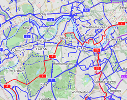
On route relations tagged with type=route and route=bicycle, route=hiking, route=foot, route=horse, route=canoe, route=motorboat, route=inline_skates or route=mtb, this key indicates the scope of the route. For example, a national cycling network is network=ncn while a national hiking trail network is network=nwn. See Cycle routes and Walking routes for lists of possible values.
由于在 自行车路线关系使用了通用的“lcn”、“rcn”、“ncn”和“icn”网络值, cycle_network=*标签也在需要更精细网络区分的地方使用,例如在美国。
额外标签 network:type=node_network在荷兰、比利时、德国和法国,它被用于表示路线关系是节点网络的一部分,即由编号或命名的交叉路口通过节点到节点的路线连接而成的网络。
设施
连同 amenity=bicycle_rental 或amenity=atm 或者 amenity=charging_station, 此标识在其他多个地点运营类似设施的组织或品牌。例如,伦敦的一个自行车租赁点可能属于“tfl_cycle_hire”网络。自动取款机(ATM)可能属于多个银行共享的网络。或者,汽车共享站点可能是某个网络的一部分,在该网络中,不同的运营商允许客户使用网络中的任何站点。
其他用途
该功能还用于以下方案中: