Zh-hant:OsmAnd
| OsmAnd | ||||||||||||||||||||||||||||||||||||||||||||||||||||||||||||||||||||||||||||||||||||||||||||||||||||||||||||||||||||||||||||||||||||||||||||||||
|---|---|---|---|---|---|---|---|---|---|---|---|---|---|---|---|---|---|---|---|---|---|---|---|---|---|---|---|---|---|---|---|---|---|---|---|---|---|---|---|---|---|---|---|---|---|---|---|---|---|---|---|---|---|---|---|---|---|---|---|---|---|---|---|---|---|---|---|---|---|---|---|---|---|---|---|---|---|---|---|---|---|---|---|---|---|---|---|---|---|---|---|---|---|---|---|---|---|---|---|---|---|---|---|---|---|---|---|---|---|---|---|---|---|---|---|---|---|---|---|---|---|---|---|---|---|---|---|---|---|---|---|---|---|---|---|---|---|---|---|---|---|---|---|---|
 | ||||||||||||||||||||||||||||||||||||||||||||||||||||||||||||||||||||||||||||||||||||||||||||||||||||||||||||||||||||||||||||||||||||||||||||||||
| 作者: | Victor Schreb & contributors | |||||||||||||||||||||||||||||||||||||||||||||||||||||||||||||||||||||||||||||||||||||||||||||||||||||||||||||||||||||||||||||||||||||||||||||||
| 執照: | GNU GPL v3 (free or 5.99€) | |||||||||||||||||||||||||||||||||||||||||||||||||||||||||||||||||||||||||||||||||||||||||||||||||||||||||||||||||||||||||||||||||||||||||||||||
| 平臺: | Android、 iOS和 BlackBerry OS | |||||||||||||||||||||||||||||||||||||||||||||||||||||||||||||||||||||||||||||||||||||||||||||||||||||||||||||||||||||||||||||||||||||||||||||||
| 版本: | 4.8.3 (2024-07-17) | |||||||||||||||||||||||||||||||||||||||||||||||||||||||||||||||||||||||||||||||||||||||||||||||||||||||||||||||||||||||||||||||||||||||||||||||
| 語言: | 英文、俄文、德文、法文、阿拉伯文、保加利亞文、波士尼亞文、捷克文、丹麥文、西班牙文、巴斯克文、芬蘭文、希伯來文、印地文、匈牙利文、亞美尼亞文、印尼文、義大利文、jp、喬治亞文、韓文、義大利文、拉脫維亞文、馬拉地文、荷蘭文、挪威文、波蘭文、葡萄牙文、羅馬尼亞文、斯洛伐克文、塞爾維亞文、瑞典文、烏克蘭文、越南文和中文
| |||||||||||||||||||||||||||||||||||||||||||||||||||||||||||||||||||||||||||||||||||||||||||||||||||||||||||||||||||||||||||||||||||||||||||||||
| 網站: | https://osmand.net | |||||||||||||||||||||||||||||||||||||||||||||||||||||||||||||||||||||||||||||||||||||||||||||||||||||||||||||||||||||||||||||||||||||||||||||||
| 源代碼: | https://code.google.com/p/osmand/source/checkout | |||||||||||||||||||||||||||||||||||||||||||||||||||||||||||||||||||||||||||||||||||||||||||||||||||||||||||||||||||||||||||||||||||||||||||||||
| 程式語言: | Java和C++ | |||||||||||||||||||||||||||||||||||||||||||||||||||||||||||||||||||||||||||||||||||||||||||||||||||||||||||||||||||||||||||||||||||||||||||||||
|
Navigation, Routing(online-offline), OSM map display (tiles or vector) (offline), POI and address search (offline), submit OSM bugs and POI, mark favorites, public transport info etc. Actively developed. |
||||||||||||||||||||||||||||||||||||||||||||||||||||||||||||||||||||||||||||||||||||||||||||||||||||||||||||||||||||||||||||||||||||||||||||||||
| ||||||||||||||||||||||||||||||||||||||||||||||||||||||||||||||||||||||||||||||||||||||||||||||||||||||||||||||||||||||||||||||||||||||||||||||||
OsmAnd (homepage) 是以OpenStreetMap為基底,在Android系統上的導航應用程式。
下載及安裝
OsmAnd共有以下三種版本:
- OsmAnd+:5.99歐元,無使用限制;
- OsmAnd:免費,但有使用限制;
- OsmAnd~:免費,無使用限制 (donate link),透過非官方market「F-Droid」自由捐款;
- 以及OsmAnd-default.apk下載點nightly build .apk(但請注意此版本「可能不穩定」或具實驗性,同時也無法自動更新。)
同時請見OsmAnd官方網站安裝頁面.
OsmAnd特色:
- 展示OSM座標地圖(*.osm.pbf, *.obf) 以及多種地圖背景(Mapnik, Google Maps/Satellite/Terrain, CloudMade, Cyclemap, OpenPisteMap, MapSurfer.Net, Microsoft Maps/Earth/Hybrid)
- 多圖層的興趣點(POIs)、公共運輸站、OSM錯誤、我的最愛、GPX軌跡以及Yandex traffic
- can use offline vector maps and address indexes created with OsmAndMapCreator
- search address/POI/location using offline indexes or online via Nominatim
- turn-by-turn voice-guided navigation, with online routing from CloudMade, OpenRouteService, OSRM or YOURS
- same via offline navigation
- auto-zoom based on speed
- auto-rotate map based on direction of movement or compass
- history and favorites
- car/bicycle/pedestrian presets
- add POIs to OpenStreetMap
Hints for using offline map data:
- offline map data files that can be used with OsmAnd have *.obf as file extension.
- in latest versions of these map files all vector map data, POIs and address indexes for offline search are included.
- you can generate your own *.obf files by getting fresh raw OSM data for example via geofabrik.de or cloudmade.com, then process these osm files with OsmAndMapCreator (Java program for desktop PC) that is offered at Osmand's Google-website (try to get latest nightly build).
- when you have several *.obf files for single regions of a certain country, you can combine them with inspector.bat or inspector.sh that is delivered with OsmAndMapCreator. Start this script on a command line without any parameters to see all options and proceed.
- Maybe there is a named street in the OSM data, but OsmAnd cannot find it via its offline address search? Run the above mentioned inspector with parameter -v and [nameofyourmapfile].obf >list.txt ... this will give you a text file with all places that are within that obf file and all streets that are associated to that place. Thus you can find out whether OsmAnd's street list is incomplete (this can have several reasons like missing administrative borders etc.)
Categories for POIs include:
- sustenance (bar, bbq, biergarten, cafe, drinking_water, fast_food, food_court, pub, restaurant)
- education (college, kindergarten, library, school, university)
- transportation (bicycle_parking, bicycle_rental, bus_station, car_rental, car_sharing, car_wash, ferry_terminal, fuel, grit_bin, parking, taxi)
- finance (atm, bank, bureau_de_change)
- healthcare (baby_batch, dentist, doctors, first_aid, hospital, pharmacy, veterinary)
- entertainment (architect_office, arts_centre, brothel, cinema, community_center, fountain, nightclub, sauna, stripclub, studio, theatre)
- tourism (alpine_hut, artwork, attraction, camp_site, caravan_site, chalet, guest_house, hostel, hotel, information, motel, museum, picnic_site, theme_park, viewpoint, zoo)
- historic (archaeological_site, battlefield, boundary_stone, castle, fort, memorial, monument, ruins, wayside_cross, wayside_shrine, wreck)
- natural (bay, beach, cave_entrance, cliff, coastline, fell, glacier, heath, land, marsh, mud, peak, sand, scree, scrub, spring, stone, tree, volcano, water, wetland)
- shop (alcohol, bakery, beauty, beverages, bicycle, books, boutique, butcher, car, car_repair, charity, chemist, clothes, computer, confectionery, department_store, doityourself, dry_cleaning, electronics, fabrics, farm, florist, funeral_directors, furniture, garden_centre, general, gift, glaziery, greengrocer, hairdresser, hardware, hearing_aids, hifi, ice_cream, jewelry, kiosk, laundry, mall, massage, money_lender, motorcycle, newsagent, optician, organic, outdoor, pawnbroker, second_hand, shoes, sports, stationary, supermarket, tattoo, toys, travel_agency, variety_store, video)
- leisure (common, dance, dog_park, fishing, garden, golf_course, ice_rink, nature_reserve, marina, miniature_golf, park, pitch, playground, sports_centre, slipway, stadium, track, water_park)
- sport (10pin, archery, athletics, australian_football, baseball, basketball, beachvolleyball, boules, bowls, canoe, chess, climbing, cricket, cricket_nets, croquet, cycling, diving, dog_racing, equestrian, football, golf, gymnastics, hockey, horse_racing, ice_stock, korfball, motor, multi, orienteering, paddle_tennis, paragliding, pelota, racquet, rowing, rugby, shooting, skateboard, skating, skiing, soccer, swimming, table_tennis, team_handball, tennis, toboggan, volleyball)
- other (bench, clock, courthouse, crematorium, embassy, emergency_phone, fire_hydrant, fire_station, grave_yard, hunting_stand, internet_access, marketplace, place_of_worship, police, post_box, post_office, prison, public_building, recycling, shelter, telephone, toilets, townhall, vending_machine, waste_basket, waste_disposal)
Adding pois and addresses
OsmAnd can be set to upload points of interest offline or online. If it is set up for offline, the pois have to be manually uploaded. Otherwise they are uploaded instantly to the OSM database.
To add a poi
- Click on a location on the map you want the poi to appear
- Click on the gray location box
- Select "Create POI"
- Type in the information in each of the fields. The other box automatically adds the key for each value selected.
- Adding address is still a little clunky but can be done.
- Select "Advanced Mode"
- Select "Add Tag"
- Type "A" in the tag box. You can't see the whole field, so you just have to remember what spot each value is in.
- Type the value in
- Click submit
- OsmAnd
-
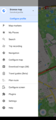 Main menu
 -
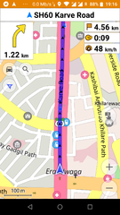 Navigating by car
 -
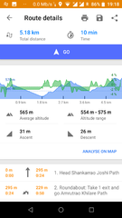 Directions for navigation
 -
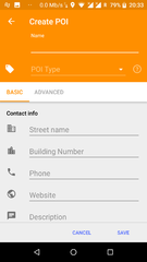 Choose/create filter poi(offline)
 -
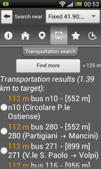 Search transport
 -
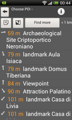 Searching closest poi(offline)
 -
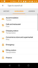 Searching by address (offline)
 -
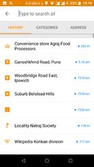 Search history
 -
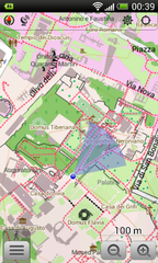 Pedestrian mode
 -
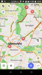 See/edit osm bugs
 -
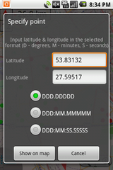 Show/go coordinates
 -
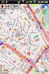 See/edit osm poi/transport over map
 -
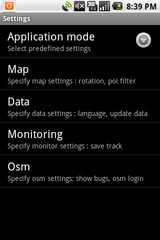 Settings
 -
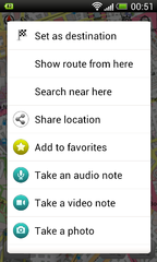 Target menu


Customizing OsmAnd
Create your own maps
See OsmAndMapCreator
Define your own rendering style
Start from the default rendering file: https://github.com/osmandapp/Osmand/blob/master/DataExtractionOSM/src/net/osmand/render/default.render.xml
Edit the file as you wish and place it on your device under osmand/rendering
Select custom rendering in OsmAnd