GeoScribble
GeoScribble is a website and an online service to collaboratively draw on the map. It is used for free-hand notes when surveying: Every Door editor uploads drawings to the website, while editors can show them as an overlay.
Background and motivation
While in the field, mapping things right away might not be an option: editing with a phone is not easy, fingers might be cold, and data connection unstable. There are alternative ways of storing the surveyed information quickly: e.g. photos, 360° panoramas, voice recordings, or simply the time-honoured practice of recording a GPX track or creating a OSM Note. Just type some words into the note and somebody will then read it and update the map according to the information provided.
GeoScribble improves upon the geometric aspect of OSM notes. Instead of explaining "This road goes from there to there", you can just simply submit a crudely drawn line. Just like with Walking Papers, you can make a rough map of roads, paths, and barriers. Once back home you can launch your preferred OSM editor and turn all these scribbles into a proper map.
When the scribbles are all mapped, you can log in to the web interface at https://geoscribble.osmz.ru using your OSM account, and you'll be able to mark your scribbles as done. (Deleting scribbles is currently only possible via the API.)
Creating new scribbles in EveryDoor
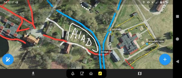
Here's Geoscribble displayed on Every Door:
To create a new scribble, change to the GeoScribble mode (the clipboard+pencil icon in the bottom navigation bar), and tap the pencil icon on the bottom left to start drawing.
Besides the graphical scribbles, you can also add labels, which are similar to OSM notes but do not have the same workflows, and are meant to complement the context provided by the drawings — for example, including the text “asphalt” next to your drawing.
Once you finish drawing, tap the upload button to send your scribbles and labels to the GeoScribble server.
Enabling the GeoScribble layer in editors
- JOSM: open preferences (F12), "Imagery", find "GeoScribble Map Notes" and activate it. Then, having downloaded some data, add the layer on top of a satellite imagery layer from "Imagery" menu. If you don't see your scribbles, right-click and choose "Flush tile cache".
- iD: open the "Background" panel, under "Overlays", enable "GeoScribble latest notes".
- Rapid: open the "Map Data" panel (key F) and enable "GeoScribble Annotations".
- Every Door: click on the fourth mode button (for notes), it's already there.
- Vespucci: select "Add overlay imagery layer..." from the "+" menu in the layer modal, select "GeoScribble latest notes". Note just as with JOSM you may have to manually flush the tile cache for the layer to see updated tiles.
API and data models
GeoScribble accepts objects of two kinds, Scribble and Label, and returns three, including a Box.
- Scribbles are line drawings. They have a style, basically a one-word tag: "road", "footway", "stream", "power". For visualizing, they also have properties like color, thickness, and dashes. Most renderers and editors rely on the latter, ignoring style labels.
- Labels are like OSM notes, but short (40 characters max), no comments and no workflows. They have a point location, color (ignored by all), and text.
These objects have no versions, they can only be added and deleted, but not updated. Identifiers are unique across all types. Also stored are an editor name, user id and name, and creation date.
- For low zooms (currently level 12 and less) instead of those objects, API returns Boxes: rectangular geohash representations with a single value: minimal age for objects inside the box. This make it easier to find fresh scribbles at a regional scale.
See OpenAPI documentation for exact definitions. Note that while it provides GeoJSON and raster WMS endpoints, the /scribbles one is the fastest, since there is virtually no overhead to it.
License
All the data uploaded is available under PDDL license, making it public domain (like CC0).
See Also
- Source code: https://github.com/Zverik/geoscribble
- Web site: https://geoscribble.osmz.ru
