Key:canoe
 |
| Description |
|---|
| Access permission for canoes, kayaks, rowboats and other small boats without a motor or sail |
| Group: restrictions |
| Used on these elements |
| Documented values: 2 |
| Useful combination |
|
| See also |
| Status: de facto |
| Tools for this tag |
|
canoe=* is the access tag for canoes, kayaks, and similar paddlecraft. It encompasses legal restrictions as well as practical factors, like water depth. canoe=* is used for both flatwater and whitewater paddling on natural and artificial waterways.
Users should be aware that different waterways have vastly different conditions. canoe=yes does not mean a feature is always safe for anyone to paddle. For instance, standup paddleboarding is typically not taken into consideration.
Legal access
canoe=* includes legal access restriction for boats without a motor or a sail. Examples include canoes, kajaks (both propelled by paddles) and rowboats (propelled by oars). In some regions this legal category has a description along the lines of "muscle powered craft", in the OSM-Seamark wiki it is referred to as "unpowered craft".
This category has the same scope as the category "Craft other than motorized vessels or sailing craft" in the UN-ECE CEVNI - European Code for Inland Waterways - (also used outside Europe either formally or informally , see Implementation document)
This category is mentioned in the following signs in OSM-Seamark tagging :
 Prohibitory sign A.16 ("All craft other than motorized vessels or sailing craft prohibited")
 Informative sign E.19 ("Craft other than motorized vessels or sailing craft permitted") .
This opposed to signs based upon other power sources, such as
 A.12 ("Motorised craft prohibited")
 A.15 ("Sailing vessels prohibited") .
In CEVNI no legal distinction is made between rowboats (typically rowing in a backwards position with oars fixed to the craft on a pivot point) and other types of muscle powered / unpowered craft which are paddled in a forward position, with a paddle that is not connected to the craft. Specific prohibitions may refer to limitations in length or width.
Access limitations can also be constituted by general access signs or legislation which might refer to on-the-ground factors such as date, water level, damage to the surroundings or physical barriers.
Values
Access values
canoe=* is generally an access tag. See Key:access for general guidance on tagging access. Common access values are given here.
canoe=yes– canoeing is legal and physically possible, i.e. it's a right of way.canoe=designated– canoeing is especially suitable and expected, particularly compared to other marine traffic or to similar routescanoe=permissive– canoeing is physically possible; it's allowed but could be restricted at any timecanoe=permit– canoeing is allowed only after obtaining a permit, which is typically grantedcanoe=discouraged– canoeing is technically allowed but may often be unsafe or impractical (e.g. open water or shallow creeks)canoe=private– canoeing may be physically possible; it's not open to the general publiccanoe=no– canoeing is not permitted or not physically possible
Other values
Two additional values are also common.
canoe=portage– Used on ways where a canoe has to be carried over land (see alsoportage=*).canoe=put_in– For places (also nodes) where the canoe is transferred (e.g. in a portage) from land to water and vice versa.
See Taginfo for all values in use.
Useful combinations
rapids=*– the presence and grade of rapids; imperative for safety!tidal=*– is the water affected by tides;intermittent=*– does the water periodically run dryoneway:boat=*andoneway:canoe=*– can boats travel bidirectionallycanoe:description=*– information specifically for paddlers (usedescription=*for general river info)
See also
Examples
-
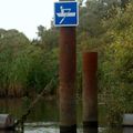 Waterway sign CEVNI E.19: "Craft other than motorized vessels or sailing craft permitted" on a canoeing route in Biesbosch, the Netherlands (placed on a construction that limits width of passing craft to approximately 1 meter)
 -
 River, legally available for unpowered boats

.jpg)
Rendering
OpenStreetBrowser renders objects of interest to paddlers (example). To enable the categories, expand: Leisure, Sport and Shopping > Outdoor activities > Paddling:
- Paddling Routes
- Paddling Amenities
- Paddling Hazards