Tag:man_made=survey_point
 |
| Description |
|---|
| A triangulation pillar, geodetic vertex, or other piece of fixed equipment used by topographers. |
| Group: man made |
| Used on these elements |
| Useful combination |
| Status: approved |
| Tools for this tag |
A ![]() survey point is a triangulation pillar, geodetic vertex, or other piece of fixed equipment used by topographers. These points are normally in a fixed location and of a known altitude used for old-fashioned surveying.
survey point is a triangulation pillar, geodetic vertex, or other piece of fixed equipment used by topographers. These points are normally in a fixed location and of a known altitude used for old-fashioned surveying.
How to map
Add a ![]() node at the location of the trig point, tagged with
node at the location of the trig point, tagged with man_made=survey_point.
It can be combined with the following generic tags: name=*, ele=*, ref=*, operator=*, description=*.
There are also three tags specific to survey markers: survey_point:structure=*, survey_point:datum_aligned=*, survey_point:purpose=*. See the tables below.
Structure
| Tag | Description | Example |
|---|---|---|
survey_point:structure=beacon
|
A large structure, typically four-legged, visible from a far distance. Sometimes called a Trig Station.
Common in Australia and New Zealand. Can be combined with |

|
survey_point:structure=pole
|
A pole is much more slender and generally taller than a pillar.
In the photo, there are two poles. The shorter pole in the foreground is also a valid example of a |

|
survey_point:structure=pillar
|
Taller than it is wide, commonly designed for surveying equipment to be placed directly onto the top of the pillar. | 
|
survey_point:structure=block
|
A man-made block built into ground, with top of block often at ground level, or up to approximately 0.5m from ground level. | 
|
survey_point:structure=bracket
|
A plaque-like bracket that allows equipment to be hooked into it.
If you cannot hook equipment into it, then it is a |

|
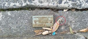
survey_point:structure=plaque
|
If there is only a plaque, and no other structure.
Use |
|
survey_point:structure=medallion
|
Circular plate embedded at the surface of a larger structure, typically a building. Survey instruments may be inserted in it for measures. | 
|
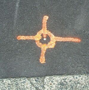
survey_point:structure=pin
|
If there is no physical structure, besides from the pin/bolt itself. See also: indented_pin
|
|
survey_point:structure=indented_pin
|
Similar to pin, except that it has an indent for inserting survey equipment
|

|
survey_point:structure=cut
|
A line cut into a wall or rock | 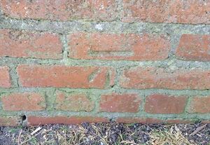
|
survey_point:structure=magnet
|
If the survey marker is an underground magnet. Please combine with location=underground
|
Example |
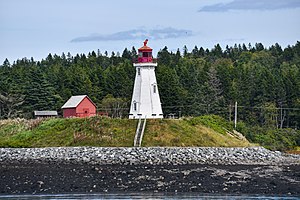
survey_point:structure=landmark
|
A landmark structure with a specific architectural feature (such as "finial" or "spire") used by a national geodetic organization as a formal triangulation point, with published coordinates derived by "classical geodetic methods". Such structures are commonly also, if located near the water, seamark:type=landmark.
This is for structures such as lighthouses, church spires, lookout towers, antennas, chimneys, etc. These objects should only be tagged with These objects should only be mapped using the exact published coordinates, reduced to WGS84 (= ITRF 2020) at the reference epoch (currently 2015.0) using software such as NOAA VDatum. This is for the purpose of using them as reference marks to calibrate satellite imagery. Please do not map these as survey points using GPS coordinates, or from their position on satellite imagery. |
|
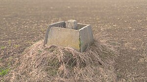
survey_point:structure=frustrum
|
An underground monument similar to survey_point:structure=block, protected by a square frustum-shaped concrete-slab upper part filled with soil. Please combine with location=underground
|
|
Condition
| Tag | Description |
|---|---|
survey_point:datum_aligned=yes
|
If the location of the marker is known to be reliably aligned to the nearest |
survey_point:datum_aligned=no
|
If the location of the marker is NOT aligned to the local This may be because of an earthquake/landslide/flood, or it was moved accidently, or moved by growing tree roots. |
Purpose
| Tag | Description |
|---|---|
survey_point:purpose=horizontal
|
Often called a |
survey_point:purpose=vertical
|
Often called a |
survey_point:purpose=both
|
If a marker can be used for both horizontal and vertical triangulation |
Notes
- If a survey marker has been destroyed, you may replace
man_made=survey_pointwithdestroyed:man_made=survey_pointif you really want to map it, but keep in mind Good practice. - If a survey marker still exists but is no longer visible, you could add
location=underground. For marks embedded into the roadway, resealing the road may have covered the pin. Another example is if a building was constructed on top of the marker.
Rendering
Survey points are currently not rendered in openstreetmap-carto.
![]() suggested by User:Chrisana13
suggested by User:Chrisana13