Talk:Tag:man made=survey point
Different types of survey points
How to make a difference between different types of survey points? International nautical maps use 4 different symbols depending if the survey point is a triangulation point, observation point, fixed point, or a benchmark. (see INT 1 B20 - B23) --Skippern 09:03, 3 May 2011 (BST)
- I see you added these to the page as type=*. That is recommended to be avoided (see Key:type) as it can be confusing or difficult to understand. For this case, it would be better to use either survey_point=* or survey_point:type=* --Neuhausr (talk) 12:57, 8 July 2015 (UTC)
Some hunting cabins have been mapped as observation points. I suppose this is incorrect ? What is an observation point ?
trig station vs survey mark
The wiki page for man_made=survey_point describes it for trig stations, but how can we map survey points which are just a small circular disk cemented into the ground? Aharvey (talk) 01:52, 16 November 2017 (UTC)
- The wiki page states 'benchmarks' too, these are not trig stations. It would be useful to distinguish between the two. The key height could give some idea of the situation, height=0 for surface marks? survey_point=benchmark/triangulation_station, benchmark:material=brass or survey_point:material=brass ??? Warin61 (talk) 23:54, 19 November 2017 (UTC)
- The definition is "survey point is a triangulation pillar, geodetic vertex, or other piece of fixed equipment" so that includes all survey marks. If you look back through the history of this page various people have tried adding sub classes only to have their work removed. Seamarks does have a tag to indicate the sub class Seamarks/Categories_of_Objects#Control Points (CATCTR) Adavidson (talk) 08:57, 20 November 2017 (UTC)
- I find encouragement that others have felt the need for sub tags. Perhaps survey_point:category=benchmark/triangulation/* with good definitions would gain use/approval? Triangulation would be something visible at distance (over 1 km), benchmark would be close to surface level. Warin61 (talk) 21:52, 20 November 2017 (UTC)
Long dead conversation, but...
- See https://www.ngs.noaa.gov/web/about_ngs/history/Survey_Mark_Art.pdf for discussion of "monumentation" of survey points in the United States, including extensive images. This document is pretty much the authoritative guide to survey point identification.
- In the case of an actual "triangulation station", historically, a portable tower (see "Bilby Tower" on Wikipedia) would be erected directly over the monument, to allow for sighting to other stations.
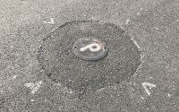
- This is triangulation station WILDER 1890 RESET 1930. https://geodesy.noaa.gov/cgi-bin/get_image.prl?PROCESSING=get_image&PID=CN0068&filename=CN0068-WILDER_RESET-1-20210128.jpg An actual trig station will not only include the surface monument marking the geodetic point, but a physically separated subsurface monument buried directly underneath (to preserve the point if the surface mark is disturbed), several nearby reference marks (to assist in locating the subsurface mark if necessary), as well as an azimuth mark around a quarter of a mile away (used as an angle reference for aligning the transit instrument used to take sightings). Wilder's function is "horizontal." The "RESET" refers to that the original 1890 monumentation was a glass bottle as a subsurface mark, and an drill hole in a large rock as a surface mark. When the mark was revisited in 1930, the subsurface mark was replaced with a medallion, the rock was returned to position, and a second medallion (the one in the image) was leaded into the hole.
- And yes, this is an obscure field of knowledge. Most survey marks are colloquially referred to as "benchmarks", but most are not actually benchmarks. An actual "benchmark" should have the elevation stamped on the disk, though sometimes that never actually happened (as this required a second visit, after the data had been reduced to determine the actual elevation).
- This is benchmark 193-2. https://geodesy.noaa.gov/cgi-bin/get_image.prl?PROCESSING=get_image&PID=CN0605&filename=CN0605-193_2-1-20110225.jpg It's function is "vertical."
- The physical orientation of a mark (vertical or horizontal) does not tell you what function it served. Most actual benchmarks are set horizontally in a concrete monument.
- This, unfortunately hard to read in this image, is Primary Transit Station No. 6 T 1926. https://geodesy.noaa.gov/cgi-bin/get_image.prl?PROCESSING=get_image&PID=CN0606&filename=CN0606-PTS_6_T-1-20110225.jpg It lives vertically on a courthouse wall about ten feet away from 193-2, and as a PTS it's function is "both." Revent (talk) 01:26, 31 October 2023 (UTC)
tag ref=* its bracket number
On the main page the ref=* it has been stated to use 'its bracket number'. I assume this is some regional reference system used in some areas of the world. I think that stating it this way will lead to other areas of the world not using it for their reference system =- thus OSM will loose that data. The statement might be better stated as "for example use the bracket number as provided in the USA." Warin61 (talk) 22:06, 31 July 2018 (UTC)
Other properties
What about defining a survey_point:order or survey_point:level subtag for the importance of a point? It can be 3 for 3rd level, etc.
One may also specify whether it is a main point at a given level.
- Is this "level" or "order" something that is marked on the survey point objects in your area? If so, then it is verifiable and you could add it. It must be an objective characteristic of the survey point. But I don't think survey markers in the USA include anything like this, so we wouldn't be able to use this tag in our country. --Jeisenbe (talk) 02:28, 14 March 2020 (UTC)
- Usually the 'level' of 'order' is related to the accuracy of the information, and would be contained in the documentation of the location together with the relevant date, etc etc. It may be publicly available, certainly available to professional surveyors. I don't think you will find it on the actual sight, certainly not in my area of the world. Warin61 (talk) 07:12, 14 March 2020 (UTC)
- There is a public list of base survey points in my country. I'll tag the data sheet URL for each POI. On the field, though, it's not so clear: Even a 3rd level point may have massive protection if needed, and there is a 1st level point without any covers. It would help the surveyors, like finding the closest high-level point. ITineris (talk) 08:14, 14 March 2020 (UTC)
The tagging could indicate whether the survey point is a GNSS base reference point, like survey_point:gnss_base=yes. ITineris (talk) 13:51, 13 March 2020 (UTC)
- This could be indicated by the physical properties enabling the mounting of a professional GPS antenna? The tagging could provide for different things and gain better use if more universal, say survey_point:function=gnss_base and possibly survey_point:form=gps_antenna_mount ??? Warin61 (talk) 07:18, 14 March 2020 (UTC)
Agency / Operator
Survey points may say:
- Fish and Wildlife board survey marker "Lifeland #21".
- Fillburg County highway department marker "HY 21 #W32".
- Nurdsburg Township office department of levels, marker "N'brg TWP #13".
- Thailand National Boundary Commission point "TH-MM #432".
- Phapburg City Plan, point #ABC3.
- Narfburg Property Bureau "PROP #77".
- Pfitzburg Military Reserve "Fine $1000 #21".
- Vietnam China joint boundary treaty commission marker #0.
etc. So there should be a standard field saying who is responsible, separate from the "name" and "ref". Jidanni (talk) 21:55, 1 August 2019 (UTC)
- Suggest using the existing key
operator=*as that is what it is intended for. Warin61 (talk) 03:16, 2 August 2019 (UTC)
Examples
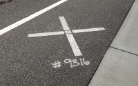
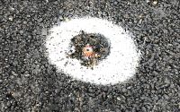
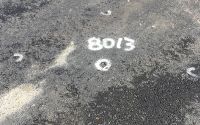
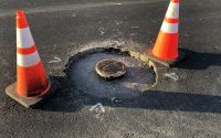
I would like to add some more examples of common types of survey point one might see when mapping.
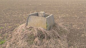
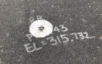
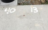
Survey points are often marked in the center line of new streets, at intersections and wherever the curvature of the street changes. Making a note of them can help a mapper draw the shape of the street more accurately.
Comments and additional examples are welcome.
T99 (talk) 08:58, 16 February 2020 (UTC)
- The above demonstrates why
survey_point=*is not good. It is being used for several different things at once. The function e.g.survey_point=benchmarkand the physical form e.g.survey_point=pin. These should be separate tags. Consider, for example,survey_point:function=benchmarkandsurvey_point:form=pin. Note: There is a proposal for benchmark presently being discussed on the tagging list. See https://wiki.openstreetmap.org/wiki/Proposed_features/survey_point:benchmark Warin61 (talk) 21:12, 13 March 2020 (UTC)
- @Warin61: Many "benchmarks" (using the term generically, here) in the US are physically "disks" (i.e. survey_point:structure=medallion) regardless of what kind of "benchmark" they are... you have to look at the disk (or look it up at the NGS) to tell what kind of control point it is. I have been using "survey_point:type" to record this. The following is from the NGS datasheet documentation:
| NGS momumentation code | definition | suggested OSM value |
|---|---|---|
| DA | Astro pier disk | astro_pier_disk |
| DB | Bench mark disk | bench_mark_disk |
| DD | Survey disk (other agency) | survey_disk |
| DE | Traverse station disk | traverse_station_disk |
| DG | Gravity station disk | gravity_station_disk |
| DH | Horizontal control disk | horizontal_control_disk |
| DJ | Tidal station disk | tidal_station_disk |
| DJ | Gravity reference mark disk | gravity_reference_mark_disk |
| DM | Magnetic station disk | magnetic_station_disk |
| DO | Disk not specified (see description) | N/A |
| DP | Base line pier disk | base_line_pier_disk |
| DQ | Calibration base line disk | calibration_base_line_disk |
| DR | Reference mark disk | reference_mark_disk |
| DS | Triangulation station disk | triangulation_station_disk |
| DT | Topographic station disk | topographic_station_disk |
| DU | Boundary marker | boundary_marker |
| DV | Vertical control disk | vertical_control_disk |
| DW | NOS hydrographic survey disk | hydrographic_survey_disk |
| DZ | Azimuth mark disk | azimuth_mark_disk |
- There are many other monumentation codes (see https://www.ngs.noaa.gov/web/tools/updates/windesc5/dformat_documentation.shtml#A.12) but these are the common ones... it's been standard since the 1930s to use medallions, and most older monuments have been reset. Revent (talk) 20:26, 6 November 2023 (UTC)
Mention how to put survey points at a given x,y
Let's say we want to put an underwater (can't see it on air photo, and no swimming allowed) survey point on the map. We have its coordinates, but we need an editor that can put it at those coordinates. Jidanni (talk) 10:54, 9 November 2022 (UTC)
- @Jidanni: Use JOSM. "Add node" (under tools menu, or shift-D) allows you to give the WGS coordinates of the point. Revent (talk) 04:36, 31 October 2023 (UTC)
Boundary turning points in rivers
Mention if it is OK to map international boundary turning points in rivers (no, there is no physical stake there. survey_point:structure=none?), or only their supporting physical monuments on the shore. Jidanni (talk) 11:03, 9 November 2022 (UTC)
- @Jidanni: Map the physical monuments. Draw the reference line in JOSM, as a temporary reference, and place a node at the intersection. Merge the corner node of the existing boundary way to your new corner node (to place it at the exact same location). Add a note field on that node, stating that it's position is referred to the intersection of reference lines from the monuments. If you know the "name" of the corner (from documentation of the boundary survey) then add that as well. Don't mark the corner as a survey point, since (as you mentioned) there is nothing physical at that location. Then delete the reference line before uploading.
- For the US, boundary monuments (and the reference markers, for maritime boundaries) are documented with NGS datasheets. These can be found with the "NGS Data Explorer" (https://geodesy.noaa.gov/NGSDataExplorer/) and give the exact coordinates in the NAD 83 reference frame. These need to be converted to WGS before being used on OSM, which can be done with NOAA VDatum (https://vdatum.noaa.gov/). This is immensely more accurate than the coordinate transformation provided by most software (including JOSM).
- The correct reference frame to convert coordinates to (the current "realization" of WGS) is "WGS (G2139)", which is not an option in VDatum. Instead, select "ITRF 2020", with target epoch of "2015.0" (this is the reference epoch at which ITRF 2020 and WGS84 (G2139) are coincident). The correct "source" epoch depends on the coordinates provided by the NGS datasheet. For NAD 83(1986) this is "1986.0" and for NAD 83(2011) this is "2010.0" (unless the NGS datasheet specifies that the coordinates given are at a different epoch.)
- If converting elevations from NGS datasheets, you will need to choose "WGS84(G1674) - use ITRF 2008" and "EGM1996(WGS84(G873))" as the target reference frame, with a target epoch of 1996.0. This is simply because OSM uses EGM96 for elevations, instead of the "current" WGS. Use the "NAVD 88" elevation as the source.
- This may seem a bit tendentious (the specific epochs) but is necessary because VDatum not only converts between coordinate systems, but includes a plate tectonic model to correct for continental drift and the effect of historical earthquakes. It is possible to convert coordinates with this software to sub-centimetric accuracy. Revent (talk) 03:22, 31 October 2023 (UTC)
- @Revent: I'm so glad that there is finally a user (you) knowledgeable about such things. I hereby dump all my concerns about the US/CA boundary in the w:Niagara River in your lap, and hope you will fix it on the map. I recall much of it is OK, but there are a few turning points out of wack that need to be moved, to make OSM reflect the real border. (Better than me screwing things up more.) Else acres and acres are shown belonging to the wrong country. Thanks! Jidanni (talk) 00:04, 9 November 2023 (UTC)
- @Jidaani: When I finish my current task (I'm importing NGS benchmarks in Alabama) I'll be happy to take a look at it... the dataset that was imported for US state and national boundaries leaves a lot to be desired. Just taking a quick look at topoView (the download tool for USGS topographic maps, which uses OSM as a basemap) I see that a significant area upstream of Horseshoe Falls is way off.
- A little Googling shows me that the International Boundary Commission actually has the exact coordinates on their website at https://www.internationalboundarycommission.org/en/maps-coordinates/maps.php so it's just a matter of converting them to WGS84. Even easier than worrying about the monuments. :) Revent (talk) 04:28, 9 November 2023 (UTC)
- They also provide it as a shapefile, but loading it into JOSM gives the (unfortunately common) "JOSM was unable to find a strict mathematical transformation between 'GCS_North_American_1983' and WGS84." error. See my earlier comments about how a non-plate-model transformation doesn't work (sigh). Revent (talk) 04:37, 9 November 2023 (UTC)
- Might as well really explain it, since someone might read this later and be interested. The NAD 27 and NAD 83 datums were fixed to measured locations on the North American Plate (Meades Ranch, for NAD 27, and a "large number" of control points for NAD 83). The original version of WGS84 was "coincident" to NAD 83 back in 1986, but they have drifted apart... NAD 83 is plate-centric, while WGS 84 is defined on the "International Terrestrial Reference Frame". It so happens that the reference geoid (model of the shape of the Earth) used by NAD 83 (GRS80) is not actually centered on the center of the Earth... it is offset by about two meters. That, combined with that the North American Plate is not actually rigid, means that the rigorous transformation between NAD and WGS84 is not only nonlinear (it's not just a "coordinate system" shift) but depends on the epoch on which the coordinates were determined. JOSM simply doesn't have the ability to do it correctly, since it's not just a shift between coordinate systems. Revent (talk) 05:01, 9 November 2023 (UTC)
- They also provide it as a shapefile, but loading it into JOSM gives the (unfortunately common) "JOSM was unable to find a strict mathematical transformation between 'GCS_North_American_1983' and WGS84." error. See my earlier comments about how a non-plate-model transformation doesn't work (sigh). Revent (talk) 04:37, 9 November 2023 (UTC)
- @Revent: I'm so glad that there is finally a user (you) knowledgeable about such things. I hereby dump all my concerns about the US/CA boundary in the w:Niagara River in your lap, and hope you will fix it on the map. I recall much of it is OK, but there are a few turning points out of wack that need to be moved, to make OSM reflect the real border. (Better than me screwing things up more.) Else acres and acres are shown belonging to the wrong country. Thanks! Jidanni (talk) 00:04, 9 November 2023 (UTC)
3D precision markers, horizontal or both?
I'd like to confirm my interpretation of the documentation of the survey points data set.
When the survey point is 3D precision, does it mean survey_point:purpose=both or survey_point:purpose=horizontal
three-dimensional coordinates in the NAD83 geodetic reference system (CSRS) (epoch 1997.0)
When you check the data sheet for individual markers, it says Planimétrie which would mean that it is survey_point:purpose=horizontal
I would appreciate someone with further knowledge can help this confusion of mine. Thanks --Wolfy1339 (talk) 01:02, 6 July 2024 (UTC)
Historical monuments
Mention how to deal with grandiose survey pillars hundreds of years old that perhaps should be also or instead tagged as historical monuments. Jidanni (talk) 13:03, 17 July 2024 (UTC)
