Tag:building=tent
Jump to navigation
Jump to search
 |
| Description |
|---|
| A building mainly consisting of sheets of fabric or similar |
| Rendering in OSM Carto |

|
| Group: buildings |
| Used on these elements |
| Useful combination |
| See also |
| Status: in use |
| Tools for this tag |
A tent is a building consisting of sheets of fabric or other material draped over, attached to a frame of poles or attached to a supporting rope.
In OSM only stationary or at least seasonal tents are to be mapped as buildings.
How to map
Draw an area marking this feature. Tag it with building=tent and optionally a name=*.
It is also OK to set a node at its center, if mapping as area is impossible.
building=ger is used frequently to tag yurts and gers - portable, round tents.
building=yurt has also been used a few times.
Examples
-
![riding tent[1]](https://upload.wikimedia.org/wikipedia/commons/thumb/3/38/Equitent_textile_Reithalle.jpg/120px-Equitent_textile_Reithalle.jpg) riding tent[1]
riding tent[1] -
![tent used for hippotherapy[1]](https://upload.wikimedia.org/wikipedia/commons/thumb/5/5e/Kryt%C3%A1_j%C3%ADzd%C3%A1rna_Hipoterapie_-_Pirueta_09.jpg/120px-Kryt%C3%A1_j%C3%ADzd%C3%A1rna_Hipoterapie_-_Pirueta_09.jpg) tent used for hippotherapy[1]
tent used for hippotherapy[1] -
![Plastic greenhouse [2]](https://upload.wikimedia.org/wikipedia/commons/thumb/4/41/Plastic_kas.jpg/120px-Plastic_kas.jpg) Plastic greenhouse [2]
Plastic greenhouse [2] -
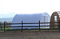 small tension fabric building
 -
![tent used as hangar[3]](https://upload.wikimedia.org/wikipedia/commons/thumb/f/ff/Haw_Farm_hangar_-_geograph.org.uk_-_1150175.jpg/120px-Haw_Farm_hangar_-_geograph.org.uk_-_1150175.jpg) tent used as hangar[3]
tent used as hangar[3] -
 Tipi (teepee) used for tourism accomodation
 -
 Circus tent (big top)
 -
![Marquee in front of a restaurant[4]](https://upload.wikimedia.org/wikipedia/commons/thumb/8/8b/Marquee_tent_with_4_peacks.jpg/120px-Marquee_tent_with_4_peacks.jpg) Marquee in front of a restaurant[4]
Marquee in front of a restaurant[4] -
![Marquee[4]](https://upload.wikimedia.org/wikipedia/commons/thumb/7/72/Marquee_tents.png/120px-Marquee_tents.png) Marquee[4]
Marquee[4]
![tent used for hippotherapy[1]](/wiki/File:Kryt%C3%A1_j%C3%ADzd%C3%A1rna_Hipoterapie_-_Pirueta_09.jpg)
![Plastic greenhouse [2]](/wiki/File:Plastic_kas.jpg)

![tent used as hangar[3]](/wiki/File:Haw_Farm_hangar_-_geograph.org.uk_-_1150175.jpg)


![Marquee in front of a restaurant[4]](/wiki/File:Marquee_tent_with_4_peacks.jpg)
![Marquee[4]](/wiki/File:Marquee_tents.png)
See also
building=ger- a ger or yurtbuilding=roof- a roof with no wall on 2 or more sidesbuilding=static_caravan- a mobile home or static caravan, permanently in one placebuilding=pavilion- a sports pavilion, providing facilities for users of sports groundsbuilding=riding_hallbuilding=sports_hallbuilding=marquee- a variety of large tent often used to shelter summer events such as shows, festivals, and weddings