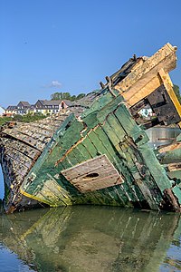
Tag:historic=wreck
| Description |
|---|
| A nautical craft that has been sunk or destroyed. |
| Group: historic |
| Used on these elements |
| Useful combination |
| See also |
| Status: approved |
| Tools for this tag |
|
A wreck is a nautical craft that has been sunk or destroyed. A wreck can persist for many centuries and can be a hazard or a point of interest.
(In technical nautical language, ships that were intentionally sunk are not wrecks (e.g. ![]() HMS Scylla), but this tag has also been used for ships which were scuttled.)
HMS Scylla), but this tag has also been used for ships which were scuttled.)
Wreck locations are of interest to:
- shipping and harbour management
- fishing
- divers
Wrecks can be in one or more significant parts (due to current movement, etc).
How to Map
Draw an ![]() Area around the wreck, or place a
Area around the wreck, or place a ![]() Node at the location.
Node at the location.
Tag the node or area as historic=wreck and seamark:type=wreck. The following additional tags are also useful:
| Tag | Example Value | Description |
|---|---|---|
| name | Yolanda | The name of the wreck. |
| tourism=attraction | If tourism attraction | |
| wreck:type | ship | The type of sunken craft (ship, plane, submarine, ...) |
| wreck:visible_at_low_tide | yes or no | Whether the wreck is visible at low tide |
| wreck:visible_at_high_tide | yes or no | Whether the wreck is visible at high tide |
| access | yes or no or permit | |
| seamark:type | wreck | |
| seamark:wreck:category | non-dangerous
dangerous distributed_remains mast_showing hull_showing |
See Seamarks/Wrecks for details |
| seamark:wreck:water_level | <empty> | |
| wreck:date_sunk | 1980-12-28 | The date that the craft was sunk, in |
| Less common tags | ||
| wreck:depth | 24 | The depth (in metres) from the surface of the water. |
| wreck:clearance | 20 | The depth (in metres) to the top of the wreck. |
| wreck:date_commissioned | 1964 | |
| wreck:gross_tonnage | 1907t | |
| wreck:length | 74.8 | In metres |
| wreck:width | 11.7 | In metres |
| wreck:cargo | porcelain | |
All depths are based on ![]() chart datum.
chart datum.
Rendering
Wrecks are not rendered in the Standard tile layer.
It it proposed that wrecks should be rendered at close zoom levels as there are very many wrecks near coastlines (especially in the UK).
See Also
