Tag:man_made=milk_churn_stand
 |
| Description |
|---|
| A current or former collection point for milk churns. |
| Group: man_made |
| Used on these elements |
| Useful combination |
| Status: in use |
| Tools for this tag |
|
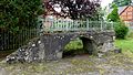
A milk churn stand is a man made structure where milk churns were placed to be collected by carts or trains on the way to the creamery. They are usually now disused for that purpose, but milk churns are often still placed on them for decorative purposes and to give a hint as to their former use. Their height corresponds with the height of the vehicle which collected the milk churns, to make it easier for the collector to move the milk churns from the stand onto the cart. They are made from a variety of materials, depending on what the farmer had at hand or how much effort they put into the building of the milk churn stand. Sometimes, steps or a ramp lead up to the platform which is regionally also known as a "stage".
They are sometimes found near post boxes.
Some have also been made part of heritage trails or open air museums or are found along walking/ hiking trails and serve as a reminder of the agricultural heritage of the area.
Some are used for geocaching.[1]
How to map genuine milk churn stands
Basic tags
Set a node or draw the area and add the tag: man_made=milk_churn_stand.
Additional tags
- material=* (If there is great variation in your country. If the majority of the stands in your country are made from the same material, this is not entirely necessary.)
- description=* containing information whether there are decorative milk churns placed on top or if there is anything else special about it
- image=* link or
- wikimedia_commons=* - link to WikiCommons
- mapillary=*
- start_date=* (In cases where they have been turned into memorials, this is sometimes noted on the plaque.)
- width=* and depth=*, if you think this information is important. It can give an idea of how many milk churns were placed on the stand.
- ele=* is not required, but when you do measure it, place your measuring device on top of the milk churn stand
If there are steps present, you might want to add step_count=*.
Memorials in the shape of milk churn stands
In some countries like Ireland, Germany and Finland, new structures are being built looking like milk churn stands. However, they serve the function of a memorial. For those, please use the tags
instead of man_made=milk_churn_stand.
Gallery
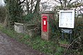
Philip Halling / Milk stand and postbox at Brushford Cross / CC BY-SA 2.0

Alan Walker / Churn Stand / CC BY-SA 2.0
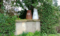
Milk churn stand in Tullahought, Ireland

David Smith: A milk churn stand at Clotworthy Farm

David Luther Thomas / Awaiting collection / CC BY-SA 2.0

Milk churn stand (Maitolaituri) in Finland

Milk churn stand in Gotland, Sweden

Milk churn stand with letterboxes in Sweden
Stone milk churn stand in Spithal, Germany

Wooden milk churn stand in Roitzsch, Germany, possibly a memorial

Newly built memorial near the location of the former creamery in the shape of a milk churn stand.


In other languages
Other languages can be found on the Wikidata page: Q10586871 Please consider adding a definition there, if you find there is one missing in a language you speak.
Proposed rendering

It is proposed to render this only on hiking or walking related maps/ apps, because the milk churn stands can serve as a landmark and are not relevant for drivers.
Possible tagging mistakes
See also
- historic=creamery
- Tutorial on how to map them: OSMForHistoryBuffs: Adding Milk Churn Stands to OpenStreetMap
- Category:Milk churn stands in the United Kingdom
- Category:Milk churn stands in the Republic of Ireland