Tag:natural=ridge
 |
| Description |
|---|
| A mountain landform with a continuous elevated crest or linear hill |
| Rendering in OSM Carto |

|
| Group: natural |
| Used on these elements |
| Useful combination |
|
| See also |
| Status: approved |
| Tools for this tag |
|
natural=ridge is used to tag a ridge: a hill or mountain landform with a continuous elevated crest. The sides of the ridge slope away on either side of the crest. The line along the crest formed by the highest points is called the ridgeline.
For sharp, rocky ridges use natural=arete instead. For a one-sided steep drop use natural=cliff.
Mapping
For mapping ridges make a way along the crest of the ridge and add name=* to specify a name. The way should only be drawn as far as there is a continuous elevated ridgeline, it should not be drawn across valleys or plateaus. The way should connect saddle points and peaks if they are along the same ridge.
Ridges longer than a few kilometers in length should be mapped with several shorter ways, divided at natural=saddle or natural=peak points. This is generally recommended for long linear featurs, such as waterway=river and highway=*.
Some mappers recommend drawing the ways so that each points up the ridge toward higher ground. Such mapping would allow rendering ridges in a way that shows the upward direction. However, since this requires reversing the direction of the way at each saddle or peak, database users should not expect all ridges to be mapped in this way.
A ridge implicitly divides drainage basins, ranging from small streams and creeks to huge rivers. This tag may later be used to derive, in conjunction with river and stream tags, the boundaries of drainage basins. However, the tag natural=ridge should not be used for flatter portions of drainage boundaries where there is not a prominent ridge line.
Cautions
- Mountain ranges should not be tagged natural=ridge, except for mountains with one continuous ridgeline, not broken by any streams, valleys or flat areas. Consider natural=mountain_range instead.
- Note that some languages may use the same word for a ridge and a long mountain range, eg "Sierra" from Spanish and "Serra" in Portuguese are used for long ridge-like mountain ranges, such as the Sierra Nevada in California, and for individual hill or mountain ridgelines. However, not all Sierras and Serras can be mapped as a ridge. The key difference is that a ridge has a continuous crest and a single ridgeline for the whole length of the feature. Mountain ranges usually consist of many smaller ridges.
- Drainage divides, including continental divides, often follow several natural=ridge ways in mountainous areas. However, a whole drainage divide should not be mapped as a single natural=ridge way. The individual ridges should stop at flat areas such as saddles and plateaus. If there is a name=*, it should be the name of the local ridge, not the name of a drainage divide or mountain range.
- Do not map a ridge as an area or multipolygon. The tag natural=ridge should only be used on a line that follows the physical ridgeline.
Examples

Walker Ridge, Klamath Mountains, California This ridge continue north as OSM way 631166206, and on the east it meets an unnamed ridge
* OSM way 631166205
* natural=ridge
* name = Walker Ridge
Unnamed ridges near La Galana peak, Ávila, Spain Note that the way stops before the saddles, where the land flattens out. Each ridge is mapped separately. See test rendering (below)
* OSM way 373957776
* natural=ridge


Druim Eileasaig Note that the ridge ends where the land flattens out on the north side. It does not continue across the flat area.
* OSM way 114017846
* natural=ridge
* name = Druim Eileasaig
Branching ridges in the Caucasus mountains These ridges are not named, but they connect named saddles and ridges. Ridges often form branching patterns, similar to streams and rivers See test rendering of this area which shows the pattern of ridges (right)
* OSM way 365672455
* natural=ridge


Crête du Liou, a ridge in France Note that the ridge begins at a saddle and ends at "Pic de Cattarabe", where another ridge joins up from the east. To the southwest it continues as a natural=arete named Crête du Moun Né
* OSM Way 326191850
Renderings
- Line and name rendered on Osmand, and OpenAndroMaps with Elevate theme.
- Name label rendered in Opentopomap.
- Rendered in the OSM Carto style (added in PR 3767)
See also
- natural=arete - a knife-edged alpine ridge created between two glaciers
- natural=mountain_range - a range of mountains, often including many individual ridges and peaks.
- natural=cliff
- Proposed features/ridge
- natural=valley (contrary)
- natural=peak
- natural=saddle
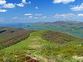
A hill ridge in Poland
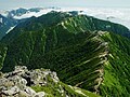
A mountain ridge in Japan
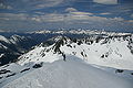
North Ridge of Mount Rohr

Ridge crest in Britain
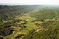
Ridges on each side of a valley in the Appalachian Mountains


